The Incredible Disappearing Car: Combating GPS Jammers

There will always be a part of the population that wants to “fly under the radar” and attempt to conquer GPS tracking devices with GPS jammers. GoFleet and Geotab are dedicated to maintaining a stable and robust system and will continue to make GO GPS devices as tamper-proof as possible.

The U.S. Federal Communications Commission defines jammers as “illegal radio frequency transmitters that are designed to block, jam, or otherwise interfere with authorized radio communications.”

A GPS jammer is used by a person in a vehicle being tracked trying to hide his or her position to try and remain undetected. The jammer can be set to operate continuously or can be turned on and off, so a specific part of a trip is not tracked.

Harsh Penalties for Jammers

Canadian and U.S. law both prohibit jamming devices. Sections 4, 9 and 10 of the Canadian Radiocommunications Act prohibit the manufacturing, importation, distribution, offering for sale, sale, possession and use of radiocommunication jamming devices in Canada. In the U.S., the federal Communications Act of 1934 outlaws the sale, marketing, or use of a jammer. There are harsh penalties related to the use of jammers in both countries, including fines (up to $112,500 in the U.S.), seizure of equipment, and even imprisonment (in the U.S.).

Where in the World Am I? How a GPS System Works

To understand how a jammer functions, we must first understand how the global positioning system (GPS) works. A GPS tracker receives microwave signals from an array of satellite transmitters orbiting the Earth at an altitude of approximately 20,200 km. Once the tracker receives signals from four or more satellites, it determines its position through a series of time calculations and trilateration.

The receiver depends on these specific and precise satellite signals to determine where it is located in the world. The GPS tracking device then transmits this position and velocity information to a monitoring location. Normally, this data is communicated over a cellular network.

GPS Satellite Signal

Figure 1: GPS satellite broadcasting signals.

In some cases, satellite malfunction or solar flares can temporarily disrupt the transmission of GPS signals. A GPS jammer sends out radio signals or signal noise with the same frequency as the GPS device, to distort or override the GPS satellite signals. The GPS device can then no longer calculate its position because the satellite signal is masked by the interference.

What is a GPS Jamming Device?

A GPS jamming device or GPS jammer is typically a small, self-contained, transmitter that generates a 1575.42 Mhz interference signal over a 5 – 10 meter radius.

Usually, the user will plug the jammer into a cigarette lighter and place the unit close enough to a GPS tracker to disrupt the GPS satellite signal. Once powered up, they become fully operational in less than 20 seconds. The relatively low power and quick start up time allow the jammers to be used only when required. Criminals will switch them off as soon as possible to avoid detection. These jammers can be purchased on the Internet for pretty cheap (less than $100).

It must be noted that the use of jammers is not only unethical but is also illegal and potentially dangerous. In one case, a New Jersey driver used a jamming device to disable a tracking device in his work truck. He was working on a job at Newark Liberty International Airport when his jamming signal interrupted air traffic control information. An FCC investigator was able to locate the jammer using radio monitoring equipment and prove that it was causing interference. The offending driver, Gary Bojczak was charged and fined $31,875.20.

How GoFleet and Geotab Detect and Eliminate GPS Jamming Threats

Fortunately, the negative effects and usefulness of jammers are minimized with our devices.

MyGeotab picks up GPS signal disruption. When a GPS signal is not received, the Trip History map will show a missing or interrupted trip — clearly calling attention to an issue.

If GPS jamming happens mid-trip, a straight line will be displayed from when the jamming starts to the point where the jamming device is turned off. Anyone monitoring the vehicle will quickly see this and can investigate the cause of the missing trip information.

GPS Jamming MyGeotab

Figure 2: A straight line in MyGeotab indicates GPS disruption.

More immediate jammer detection is also available. The GPS module in our GO6 and GO7 devices have a jamming detection function that will trigger our device to report a debug log. This can be found in the log details of MyGeotab, appearing as: GpsJammingDetected.

For simplified monitoring of jamming and other GPS issues, an exception rule can be created in MyGeotab. This rule will generate an exception report and can trigger an alert or email for the event.

It is important to note that a GPS jammer disrupts GPS receiver functionality but all other functions are unaffected. The Geotab GO device will continue to gather and send information such as engine data, error codes, and auxiliaries, etc.

Source:
Original Article By: Vincent Scime, RMA Manager at Geotab
https://www.geotab.com/blog/combating-gps-jammers/
Active Tracking: Keeping First Responders Safe on the Road

An ambulance drives through traffic, siren sounding and lights flashing. The dispatcher is on the line, collecting vital information, while monitoring the status of the ambulance at the same time. What if that dispatcher could follow the live movement of the ambulance as it drives along the road, knowing it was safely and quickly arriving at the scene?


This is now possible with Active Tracking.
 

What is Active Tracking and how does it benefit emergency vehicles?
Play the video to see it in action.
 

Paramedic Services, Fire Departments, and Police are all under pressure from the public to reduce response times, while protecting the safety of pedestrians and drivers on the road. Technology plays an important role in this effort.

Ideally suited for first responders, delivery and taxi fleets, and any industry in which knowing the precise vehicle position is critical, EMS GPS tracking system allows customers to view their vehicles in near real-time. For example, an ambulance dispatcher can watch the vehicle’s progress and reassure a caller that the ambulance has just turned off the highway onto their street. Another fleet dispatcher could closely monitor vehicle activity and see, at a glance, if a driver is driving too fast.

Using Active Tracking is very much like watching your fleet vehicles from a traffic helicopter.
Watch live as the vehicle slows down for traffic, accelerates, stops at the side of the road, or speeds down a winding road.

How It Works

Active Tracking is made possible with increased data logging frequency and animation in MyGeotab. The animation feature displays estimates of the real-time location of the vehicle onto the live map. Users are able to watch a simulated icon of the vehicle as it is moving. This new feature provides fleet managers and dispatchers with a very accurate representation of where a vehicle enabled with this technology is located at any given time.

When Active Tracking is enabled, smart technology is used to request data from the Geotab GO Device at varying frequency intervals. Then, the data is relayed to servers for processing and the position of the vehicle is reflected on to the live map. When the triangle icon is shown, this means the vehicle is in motion. As the vehicle slows down or speeds up, that change is also reflected in the movement of the icon on the map.

Previously, data was spooled into a buffer and then uploaded when the buffer was full. With this concept, some data could have been uploaded quite fast if the buffer was filled quickly. On the other hand, if there was less overall data coming in, it took the buffer longer to get filled and therefore the data would be received much slower.

To explain the data spooling and buffer concept, we can compare it to a filling a gooseneck jug with water using a cup versus using a funnel. If you were to use the cup to start filling the jug, you would have to wait until each cup was filled, then take the cup and carefully pour the water into the jug. This process would be extremely slow. Alternatively, if you inserted a funnel into the gooseneck of the jug, and poured the water directly into it, the jug would be filled pretty quickly. There would be much less of a delay using the funnel. Active Tracking is comparable to the “funnel method.”

Using patented algorithms, MyGeotab presents that granular location information on an animated map, demonstrating the steady vehicle movement — instead of the jagged jumps that are seen with other telematics solutions. As a result, Geotab’s Active Tracking solution provides deep, actionable insights that are particularly useful in applications where the exact location of a vehicle for dispatch purposes is essential.

How to Enable Active Tracking for Fleet Vehicles

Through the ProPlus Plan, you are able to activate features such as Active Tracking, third-party integrations and other special features. Active Tracking is automatically enabled for users on the ProPlus Plan. Our customers with the Pro Plan can turn on Active Tracking on the MyGeotab Vehicle Edit page (note: enabling this feature moves the device from Pro to ProPlus). Active Tracking is also required for time-sensitive server-based notifications and rules such as posted road speed warnings for the driver using GO TALK live in-vehicle verbal coaching solution.

For more information on Active Tracking or to upgrade your current plan to include Active Tracking, contact our support team.

Source:
Original Article By: Owen D’Acres, Customer Support Specialist at Geotab
https://www.geotab.com/blog/active-tracking-first-responders/

Geotab Updates (December 2015)

New updates to Geotab software applications and firmware.

Check your build number to verify whether the changes are reflected in your system by going to Administration/About. The build number shows the month of release, for example: 5.7.1512.xxx release/2015-12.


In this Edition:

  • Map Enhancements
  • Reporting Enhancements
  • Localization
  • Minor User Interface Enhancements
  • Firmware Notes


Map Enhancements

Geotab empowers fleet managers with several new ways to interact with the map.

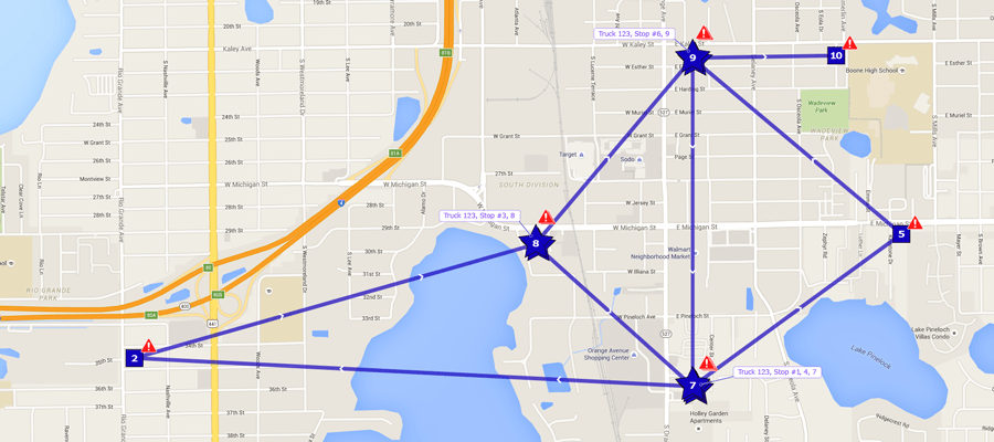
Quick View for Individual Vehicle Trips: A new feature makes it possible to quickly view the different trips a vehicle has made on the map. The Trips History displays where a vehicle has been on a particular date. Putting your mouse over any trip in the left-side trip list will now highlight the corresponding trip on the map.

Note: A trip begins when the vehicle starts moving and ends when the vehicle starts moving again after a stop. Any idling is associated with the previous trip.

mygeotab view individual trips
Figure 1: Mouse over a trip to view the corresponding route on the map.

Nearest Vehicle Toggle On/Off Added: Toggle action has been added to the Nearest map view option. In a map, left-clicking on a road, then selecting Nearest will show the nearest vehicles to that location in a tooltip.

When the button is toggled on, the tooltips and vehicle are shown. When toggled off, the vehicle remains visible on the map but the tooltip is hidden. The toggle prevents having to clear the map, which will be a time-saver for managers of large fleets.

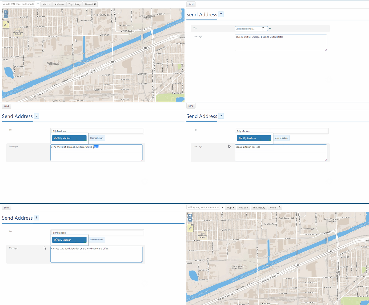
One-Click Dispatching from Live Map: Dispatching has been simplified! MyGeotab users can now dispatch vehicles directly from the live map. Left-click on the map at a particular address, then click Dispatch vehicle here to send a dispatch text message to a driver using the Geotab Drive app or a Garmin device.

mygeotab dispatch vehicles

Figure 2: Send dispatch messages to drivers with a single click on the live map.

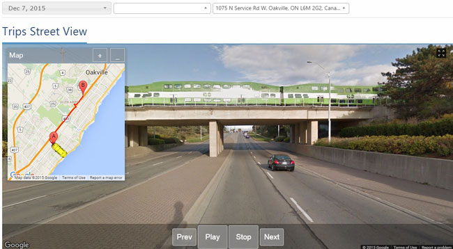
Google Street View Trip Replay: Enrich your knowledge of trips with Google Street View. See for yourself the routes your drivers are taking. Replay a trip through Google Street View using the Trips Street View Add-In — featuring pause, rewind, and skip ahead options. Once added into your database, you can view it under the Activity link. Go to the MyGeotab SDK Add-In examples page to download and extract the Trips Street View Add-In. *For more info on Geotab’s Software Development Kit, read this quick overview: Learning the MyGeotab SDK.

mygeotab google trips street view

Figure 3: Experience a panoramic view of a driver’s route with Trips Street View.


Reporting Enhancements

Geotab is always looking for ways to make it easier to examine and manage your data for fleet optimization. Recently, the following enhancements were made for MyGeotab reporting.

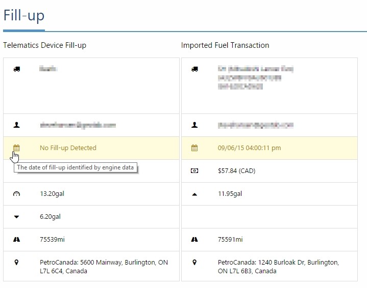
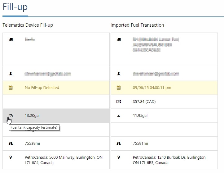
Fill-ups: You can now download, customize, create dashboards, and schedule Microsoft Excel reports for fuel fill-ups. New colored icons in the Fill-ups report show potential discrepancies, such as a fill-up being larger than the known tank size, mismatched locations, etc.


Note: This feature is in beta. These are just approximations.


mygeotab fuel discrepancy

Figure 4: Fuel discrepancy icons.

mygeotab fuel discrepancy details

Figure 5: Fuel discrepancy details.

mygeotab fuel tank capacity estimates

Figure 6: Fuel tank capacity estimates.

Start Day Option for Reports & Dashboards: To harmonize viewing and reporting, MyGeotab users can now set their preference for their week start day. To configure a user’s preference, go to Administration > User, select the user, then click Options. At the Weeks starts on drop-down menu, select either Saturday, Sunday, or Monday. The chosen first day of the week is reflected in reports and dashboards.

mygeotab work week start

Figure 7: Week start day drop-down menu.

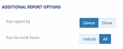
Time Card Report: MyGeotab users can schedule Time Card Dashboard or email reports to run for device work hours. To enable this option, go to Administration > Reports > Report views and select the Built-in Time Card report. In the Dashboard or Email tab under Additional Report Options, click.

mygeotab time card work hour

Figure 8: Work hour selection in Dashboard/Email report.


Localization

Some formatting adjustments were made to German and Japanese text.


Minor User Interface enhancements

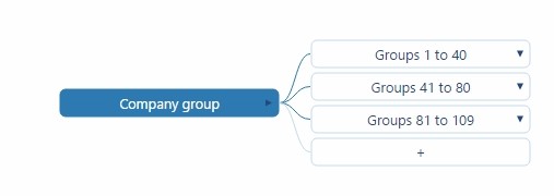
  • Access and manage your groups more quickly with a revision to the way hierarchies are presented. For groups with large numbers of sub-groups, users can now expand and collapse those subsets.
  • Ability to edit dashboards now tied to “Change your own user options” feature setting in Security Clearances. Previously, In order to edit your own dashboard (Rearrange reports, add or remove remove reports) you need to have the clearance “Administer Users/Drivers” enable. Now users with the View Only clearance can edit their own dashboard.

mygeotab manage sub-groups

Figure 9: Expand and collapse sub-groups.


Firmware Notes

Geotab releases new firmware on a quarterly basis. For the complete list of updates, please visit the Release Notes page.

Q4 2015:

Go7
New Version: 107.6.20/109.6.20 (Q4 FW)
Previous Version: 107.5.35/109.5.35 (Q3 FW)

Go6
New Version: 102.8.20 (Q4 FW)
Previous Version: 102.7.35 (Q3 FW)

Main Features:

  • Support for WWH OBD (EU Region) Data (including Status and Fault data)
  • Numerous fuel improvements including support for E85/Flex Fuel, enhanced EU fuel support and improved reliability of fuel level data around fill ups
  • Increase ODO support (ex. Fiat 500, numerous other EU vehicles)
  • Support to bypass Accelerometer calibration
  • HID RFID Trigger support
  • Enhanced Hybrid/EV data support (Charging/battery/current status)
  • Fuel units at IGN OFF fix
  • Fuel usage for flexible fuel vehicles using ethanol
  • Renault/Smart Passenger Seatbelt

Main Fixes:


  • All fixes from equivalent Aug 2015 version (107.5.40/109.5.40/102.7.40)
  • Alternative Reverse detection
  • Iridium Emergency fixes
  • Add Z to accident level event to detect rollover
  • WiFi and cellular failover improvements
  • VW Data for EU/SA
  • Add support for WWH OBD
  • Intermittent Logic improvements for J1708
  • HID RFID Trigger
  • Only process Fuel Level with IGN ON (EU Fuel Fix)
  • DTC UART message support for Third Party devices
  • Support to bypass Accelerometer calibration
  • Improve reliability of fuel level data around fill ups
  • Add Hybrid/EV Charging Status
  • Fix BMW alarm on door lock issue

Questions or Comments?
If you have any comments or questions, please email: [email protected].

For more information on our devices and software, refer to our Product Guide, available at https://stagingms.gofleet.com/support/product-guide/.

Source:
Original Post by: Angie Milne, Solutions Specialist at Geotab
https://www.geotab.com/blog/geotab-updates-preview-december-2015/


The ELD Final Rule Has Arrived! (Finally)

The ELD Final Rule has finally been released by the FMCSA.


On December 10th, 2015, the FMCSA announced the new ELD mandate. It is expected to save 26 lives, prevent 562 injuries, avoid 1,844 crashes, and result in savings of over $1 billion dollars in paperwork on an annual basis.

It’s also estimated that nationwide about 3 million drivers will be affected by this new legislation.

You can check out the full release from the FMCSA here.


ELD Solutions Already Available

ELD Final Rule HOS Solution

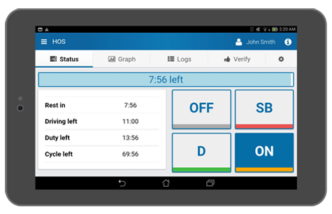
Geotab Drive, our comprehensive ELD solution, is already available in both the Apple App Store and the Google Play Store. The application connects to the GPS GO device in order to provide an automated process for creating accurate records of the drivers time spent in each duty status. The system is very user-friendly and allows drivers to spend more time completing their daily tasks by simplifying the annoyance of always documenting their time. Through this automated process, fleets are finding as much as en extra hour a day! That directly translates into added productivity.


Geotab Drive is BYOD


One of the core features that make Geotab Drive stand out from it’s competitors is that it’s a BYOD (Bring Your Own Device) solution.

ELD Final Rule Geotab Drive

  • Support off-the-shelf iOS and Android tablets
  • Plug-and-play, easy installation (no roof mounted antennas necessary)
  • Flexible open platform for adding and removing rulesets in case regulations change
  • Create driver applications using Geotab’s open APIs and SDK
  • One device runs all the driver’s favourite driver applications
  • Over-the-air firmware and software updates


Geotab Drive Benefits


  • US Federal FMCSA 395.15 compliant
  • Track regulated driver’s time spent in each duty status
  • Automatic duty status changes: Driving to On Duty; On Duty to Driving
  • Alerts for drivers not logged in
  • Violation alerts
  • 16 hour day support
  • Co-Driver support
  • Platform for dispatch application support
  • Platform for future rule support
  • Adverse weather condition support
  • Visibility in MyGeotab reporting of driver logs, violations, and remaining hours

The ELD Final Rule is not going to be pushed back any longer, so why not start using an electronic logging device (ELD) now? You are going to have to in the near future, and it will save you both time and money over using paper logs.

Speak with a specialized fleet consultant today to find out whether the ELD Final Rule affects you.


Contact a Fleet Consultant | Phone: 1-888-998-1122

Extended Functionality with Geotab SDK

GPS fleet management solutions vary from one company to the next and no two are the same, just like no two company’s fleet management needs are the same.

Implementing telematics for your business growth means staying focused on your 5 year business plan and tapping into the potential of the rich data that is available, in addition to extending the information to help make measured management decisions. By setting milestones, you will be able you to achieve a long term vision for growth. The future of telematics is connecting data with business processes and operations.

GoFleet does not simply offer an out of the box GPS telematics platform, we take full advantage of the Geotab API & SDK to work with companies to extend functionality and provide the utmost value to our clients. Working closely with our partner, ZenduIT, we provide anything from dispatch solutions, Truckmate integration and maintenance management, to completely custom solutions created for your business.

What exactly is the Geotab SDK?

A Software Development Kit (SDK) is a set of software development tools allowing for the creation of applications. Essentially, it’s a platform that helps people further extend the functionality of MyGeotab. The SDK contains many Application Program Interfaces (APIs); the APIs are used to communicate with the raw data seen in the MyGeotab application such as Devices, GPS data, Trips, Engine Data, and so much more. They provide you with the extended ability to add, update and remove data from the system using different sources other than the MyGeotab application and are securely exposed via HTTPS (the web standard that is the foundation of data communication for the World Wide Web). By using this web standard it means the SDK can be utilized through a large variety of systems.

Learn More about the Geotab SDK

If you have a custom solution request, feel free to contact one of our fleet consultants to discuss it; if we do not already have what you are looking for, our partners at ZenduIT are always looking to take on new challenges and they would be happy to assist.

Duty of Care for Fleet Managers

Innovation is changing the entire transportation industry. Uber has disrupted the way we move in a city. Google and some OEMs are actively developing autonomous vehicles that will take us from one place to another without human interaction. Amazon has patented an algorithm that predicts which products are going to be requested, so delivery vans can carry them to their destination before the order is even placed. Vehicle-to-vehicle (V2V) communications and other Advanced Driver Assistance Systems (ADAS) are being designed for the exchange of safety critical information in real time to avoid collisions.

Transportation is becoming faster, more efficient, safer, and easy to use. One day the roads will be accident-free. But unfortunately, that time has not yet arrived and nowadays companies using vehicles (which is virtually every company) need to protect their most valuable assets — their drivers.

The article below reviews legislation related to duty of care and outlines five specific ways that GoFleet and Geotab help managers keep drivers safe while also complying with the law.

Legislation Governing Drivers At Work

Companies with drivers on the road are conscious of the negative consequences of accidents and try to reduce the related risks. The improvement of driver behavior reduces injuries and saves lives, but also has an impact on company profitability by lowering insurance premiums, vehicle repairs, and tickets. Due to the serious impact of traffic fatalities worldwide, some countries are proactively approving laws to enforce companies to take the right measures. These measures typically limit windshield time, foster vehicle inspections, and enforce compliance with road signals.

In the U.S., Hours of Service (HOS) regulations are issued by the Federal Motor Carrier Safety Administration (FMCSA) and govern the working hours of commercial motor vehicle (CMV) drivers. The FMCSA recently released the final rule on electronic logging devices (ELDs) in all commercial trucks, currently under revision by the White House.

In the European Union, Regulation (EC) 561/2006 provides rules for driving time, breaks and rest periods required for drivers of goods (vehicles with more than 3.5 tonnes) or passenger vehicles (more than 8 passenger seats) within the EU.

One of the countries with more advanced initiatives in this field is the UK. Companies with fleets have a duty of care which is regulated by the Health and Safety at Work Act 1974 and the Corporate Manslaughter and Corporate Homicide Act of 2007. Employers have a legal obligation towards their workers in minimizing risk. Companies must comply with duty of care obligations to make sure their drivers are safe on the roads; if a driver causes an accident that could have been avoided by certain enforced policies, the company could be prosecuted and subject to possibly unlimited fines.

Managing HOS or Duty of Care Obligations with GPS Fleet Management

There are multiple ways a company can address their duty of care obligations, including risk assessments, disciplinary measures and extra training for drivers. These measures can have a positive effect, but employers who want to bring safety to the highest quotes promote the use of the most-advanced telematics systems. We offer a unique solution designed with safety features at its core and proven results drastically reducing the number of accidents.

Traditional telematics solutions record location, patterns and routes, driving times, and provide a logging system to ensure timetables are met. This was also the starting point for Geotab when the company began 15 years ago in this industry. Continuous effort in innovation and R&D has enabled Geotab and GoFleet to take duty of care compliance to the next level.

Five Reasons to Use GoFleet and Geotab for Duty of Care Compliance:

  1. Mobile App for Monitoring Accurate Driving Times.
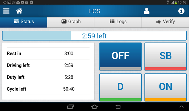
    It is not enough to simply measure and report drive times. A fleet management solution should be able to inform your drivers about their hours and alert them when they are about to break driving hours rules. The Geotab Drive app for iOS and Android tablets and phones help drivers take full control of their time and schedule their stops accordingly.

    Geotab Drive HOS App
    Figure 1. Geotab Drive Mobile App.


  • Advanced Driving Behavior Monitoring.
    The motor insurance industry has demonstrated that there are driving patterns that have a high impact on risk beyond overspeeding and mileage. We help to identify bad driving habits, so they can be directly addressed with the driver before they become a problem.

    a. Harsh acceleration/cornering/braking.
    This indicates a dangerous driving style and usually indicates that the driver is not keeping an appropriate distance away from the vehicle in front. We provide scientific values for triggering those events, taking into account if the vehicle is a car, truck, or van.

    b. Reversing at the beginning of the trip.
    Safety associations estimate that almost 25% of accidents can be blamed on poor reversing techniques.

    c. Seatbelt usage.
    The severity of an accident is much higher if drivers fail to wear seatbelts. Although a difficult undertaking, Geotab invests a lot in getting seat belt buckled information from a vast variety of makes to ensure this information is accurate.


  • In-Cab Verbal Coaching.
    Fleet managers can work with their drivers to improve driver behavior by discussing bad habits using the reports from the system. However, using verbal feedback to coach drivers while they’re on the road is even more powerful. The GO TALK accessory can relay predefined and customizable messages when drivers are performing poorly in any of the variables discussed above.


  • Vehicle Inspection, Maintenance, and Proactive Alerts on Engine Faults.
    The status of the vehicle parts, especially brakes, tires, and safety elements, is an important factor in driver safety and compliance. We offer a complete and flexible maintenance system including service reminders and proactive alerts of engine faults and maintenance issues like battery drain, oil level, engine warning light on, coolant temperature, and more.


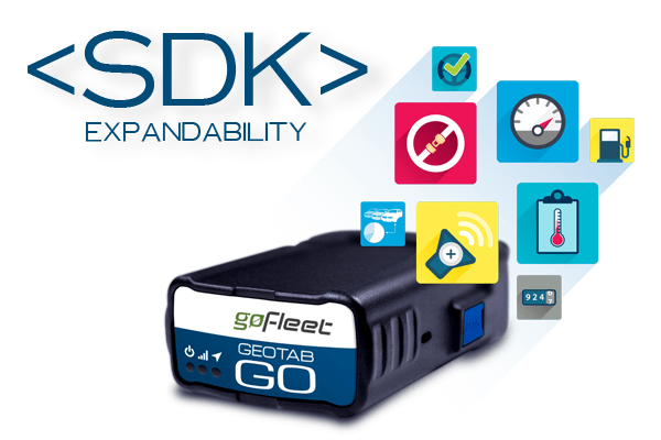
  • Expandability.
    We now offer a wide variety of solutions from different partners allowing Fleet Managers to add even more safety features to our core solution. For example, the Mobileye collision avoidance system warns drivers of impending collisions, following too close, or unsafe lane changes with audible and visual alerts.


Keep your drivers safe and simplify compliance at the same time; our fleet management software platform has been designed to give full control to customers while keeping the user experience simple and intuitive.

Need more information? Contact one of our fleet consultants today: [email protected].

References:
Original Blog From Geotab, By Ivan Lequerica, European Solutions Engineering Director
https://www.geotab.com/blog/duty-of-care/

Quick Guide: MyGeotab IFTA Management

How does GoFleet and Geotab help with IFTA management? Read this Quick Guide to learn how to set up an IFTA Report in MyGeotab.

What is IFTA?

The International Fuel Tax Agreement (IFTA) is an agreement between 10 Canadian provinces and 48 American states concerning the taxing and reporting of motor fuels used by interjurisdictional carriers operating heavy commercial vehicles.

Under the IFTA, interjurisdictional carriers must report the distance travelled in each jurisdiction and the amount of motor fuel consumed. The carrier reports and pays motor fuel taxes to a single jurisdiction and then the member jurisdictions (states and provinces) handle the sharing of tax revenues.

Using paper records for IFTA opens the door to potential issues such as missing paperwork, late filings, error due to manual entry, overpayments, or audits.

GPS Tracking for IFTA Management

Although designed to be a simpler system, IFTA reporting can be a labor-intensive and time-consuming process for fleet owners and managers – especially those working with large fleets.

IFTA management is made easier for fleets with GPS vehicle tracking, by reporting the GPS location and time in each location for fleet vehicles. Our software saves IFTA management time by removing the manual process of tracking miles by province/state and improving accuracy.

Benefits of IFTA Management with GoFleet and Geotab:

  • Minimizes risk of violations
  • Helps cut down on paperwork
  • Reduces administration costs
  • Improves driver efficiency

Geotab IFTA Report for Location Tracking

The Geotab IFTA report uses the odometer value to determine how far fleet vehicles have driven within the individual taxable provinces or states.

Three Simple Steps to Creating a Geotab IFTA Report:

  1. Log in to MyGeotab.
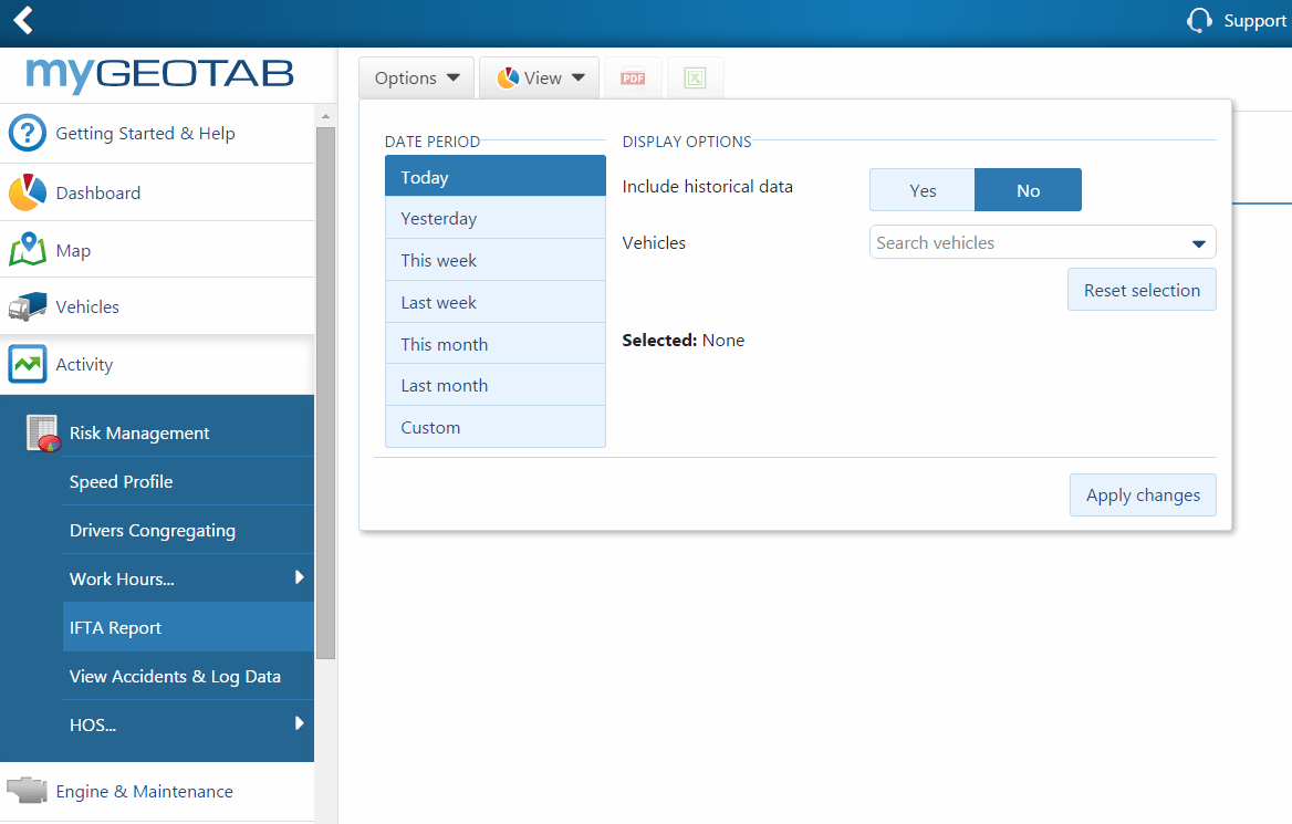
  2. On the left-hand menu, click Activity, then click IFTA Report.

Click on the Options button to define the date period and then choose your vehicles.

IFTA-report-mygeotab
MyGeotab IFTA Report Screen

The Fuel Tax report also allows you to filter the mileage into IFTA and non-IFTA provinces/states (Yukon Territory, Northwest Territory, Nunavut, Hawaii, Alaska, District of Columbia, and Mexico). Look at the Advanced Fuel Tax Report’s “Summary” or “Report” sheets for the “Is IFTA Province/State?” field.

Ensuring IFTA Report Accuracy: How to Correctly Transfer a GO Device Between Vehicles

Incorrectly transferring a telematics device from one vehicle to another can affect the accuracy of the data stored in MyGeotab related to International Fuel Tax Agreement (IFTA) or Fuel Usage reporting.

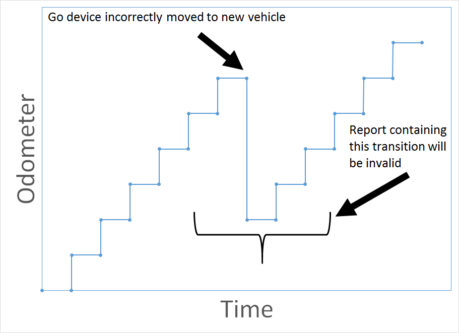
Given the plug and play design of the GO7, it may be tempting to simply unplug it from the current vehicle and plug it into the new vehicle, but this is not recommended. If you run a report which uses odometer values, like the Fuel Tax report, plugging and unplugging will generate incorrect or negative values for the dates around when the device was moved. This cannot be corrected and it will invalidate the entire report.

For example, the graph below shows what would happen to the odometer value if a device was incorrectly moved from a vehicle with a high odometer value to a vehicle with a lower odometer value.

chart-incorrect-device-transfer
Odometer discrepancy due to incorrect GO device transfer.

How can you ensure reports remain accurate when you need to move a device into a new vehicle? Simple! Follow the procedure below.

The Correct Way to Transfer a GO Device Between Vehicles

  1. First, unplug the GO device from the old vehicle. Then, in your MyGeotab database, go to the Vehicles section and select the old vehicle from which you just unplugged the GO device; you’ll see the Vehicle Edit page. Click the More details button.
  2. Copy the GO device serial number to your clipboard. This will save time when creating the new vehicle.
  3. Choose Unplug Device. This will also make the vehicle historical. All the data and location history for historical vehicles remains available for viewing and reports.
  4. Return to the Vehicles section and click Add, then Add vehicle.
  5. Paste the serial number from your clipboard into the Serial number field and give the new vehicle a description. Click OK to continue.
  6. Configure Driver Feedback for the new vehicle or add any custom parameters required. Once finished, click Save. The GO device is now ready to be installed in the new vehicle.

View the screenshots – Read Renee Depuydt’s blog: Benefits and Steps To Transferring Telematics Devices Between Vehicles for additional instructions on transferring a vehicle tracking device.

More Tips: Re-activating an Historical Device

If you need to move the GO device back to the old vehicle, first follow the steps above to make the current vehicle historical. Next, navigate to the Vehicles section and click Show historical. Find the old vehicle name in the list, and click on it to open the Vehicle Edit page. Click More Details to reveal additional options. Select Replace with new device. Enter a GO device serial number and click OK to re-activate the historical device.

It’s crucial you follow the steps listed above when moving a GO device between different vehicles. If you have any questions or concerns regarding this process, please contact us for more information.

Watch the MyGeotab Default Reports video to learn more about reporting in MyGeotab, including details on the IFTA Report.

References:

Original Blog From Geotab, By Ethan Weir, Technical Services Engineer
https://www.geotab.com/blog/mygeotab-ifta-report/

Ground Support Equipment: The New Frontier for Telematics Growth

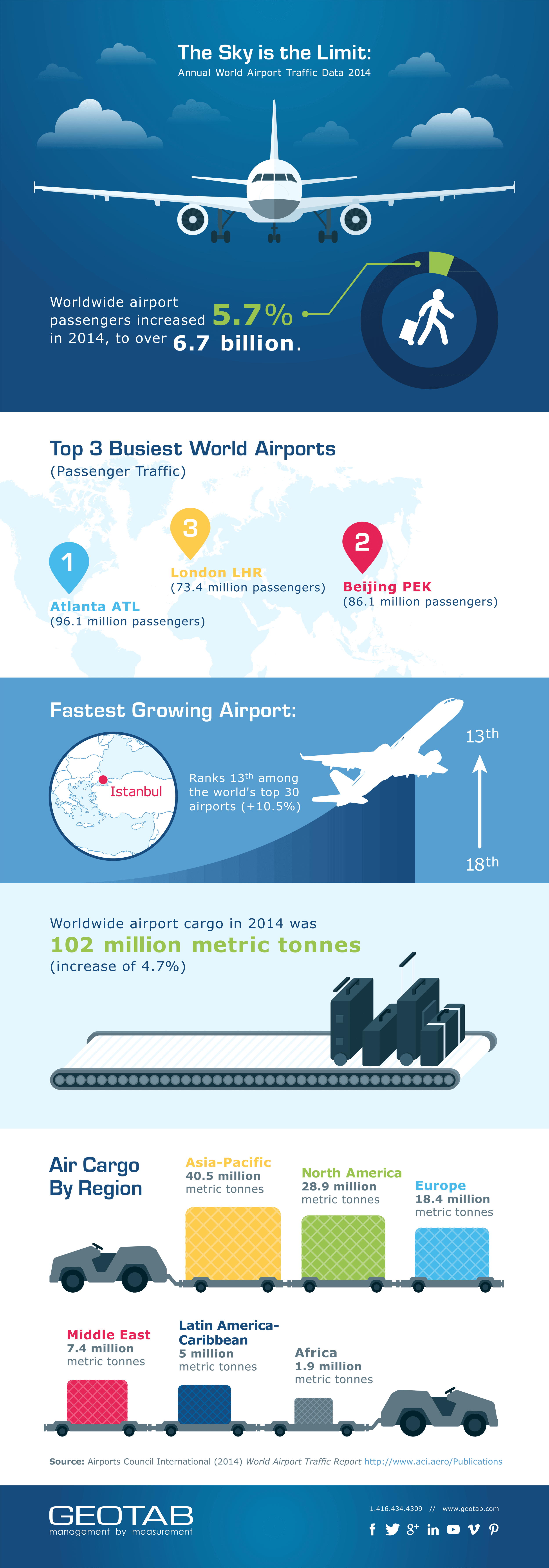
Global passenger traffic and air cargo volume are on the increase, according to the latest edition of the World Airport Traffic Report from the Airports Council International (ACI).1 Although figures for 2015 have not been finalized, the ACI predicts that air traffic will continue to rise. The rising volume of airport traffic signals a potential opportunity for growth in telematics. Air operations are costly and time-sensitive. Fleet management and vehicle tracking of airport ground support equipment (GSE) such as baggage/cargo handling tugs, tractors, refuelers, and container loaders can provide the visibility and information required to streamline operations, increase safety, and control costs.

Benefits of using fleet management for ground support equipment:

  • Reduced set-up time for operations with real-time location visibility of equipment; searching for loaned or borrowed equipment will be a thing of the past. Alerts can be generated for assets entering no-go and restricted areas or assets leaving your work.
  • Easier and more accurate tracking of mileage and hours. Eliminate time-consuming and costly physical monitoring and checking.
  • Reduced maintenance and fuel costs through monitoring of power take off use and engine idling time. Auxiliary inputs are available to use a vast number 3rd party devices and other sensors.
  • Lower costs related to maintenance and down-time. Monitoring diagnostic trouble code information makes it possible to proactively attend to equipment issues early before they turn into asset down-time or costly repairs.
  • Improved airport safety by enforcing safety policies like start-up sequences and seat belt use, and by detecting aggressive driving on driveable assets.
  • Lower risk of unauthorized use by tracking off-hour usage. This information is also available on older equipment without a diagnostic port. Both 12 volt and 24 volt assets can be equipped.
  • Greater warranty compliance with maintenance alerts and schedules.

For other industry-specific solutions, visit the Geotab Marketplace to view the existing portfolio of MyGeotab Add-ins, Mobile Apps, Hardware accessories and Add-On, Custom Reports and General Software Solutions.

geotab aviation annual report

download-infographic-btn

References:

Original Blog From Geotab, David Bradley, Engineering Consultant
https://www.geotab.com/blog/ground-support-equipment/

Airports Council International. (August 31, 2015). ACI Releases 2014 World Airport Traffic Report: Airports In Advanced Economies Rebound In 2014 – Global Passenger Traffic Up By Over 5%; Air Cargo Volumes Rise After Three Years Of Stagnation – Aug 31, 2015.
Retrieved from http://www.aci.aero/News/Releases/Most-Recent/2015/08/31/ACI-releases-2014-World-Airport-Traffic-Report-Airports-in-advanced-economies-rebound-in-2014–global-passenger-traffic-up-by-over-5-air-cargo-volumes-rise-after-three-years-of-stagnation-


Immobilization, Driver Identification, and Safety

Safety is incredibly important at GoFleet, whether in relation to drivers themselves or maintaining the integrity and safety of client data. All Geotab services and products – both old and new – are constantly held to this paradigm.

Below, we will dive further into engine immobilization and describe how the NFC Tag Reader and the Driver ID Relay can be used to help manage the on-road safety of fleet drivers.

The Importance of Professional Installation
Because of the high variety and assortment of vehicle electronics and electrical circuits, it’s apparent that it can be challenging to wire the relay in a way that is fail-safe for immobilization. In a situation where an individual is not a licensed automotive electrician or equivalent, the complexity of the installation can lead to a vehicle not being able to start if for example the relay or a part of the circuit fails. No one wants to be responsible for causing a vehicle to fail to start when someone really needs to get home. To ensure a quality install, we recommend professional installation by a knowledgeable technician.

How Geotab Supports Driver Identification
The combination of the Driver ID system with the GO device is designed to ensure that the driver identifies themselves before they begin to drive. Adding a relay to the Driver system can activate a switch or turn a third party device on or off. It can even be used to activate a third party drive inhibitor or rev limiter that is both effective and safe. Geotab and its providers can’t always guarantee that a vehicle can be immobilized 100% reliably. For example, it will not work if there is no cell network coverage. The included relay can be used as part of the immobilization solution, but Geotab’s support ends at the functioning of the GO device and the relay. A licensed automotive mechanic/electrician would need to select an appropriate inhibitor for installation. There is a different standard applied to systems that can affect safety versus systems that can’t and it is important customers understand this point.

This is the reason the relay should not be wired-in directly for immobilization. The wiring diagrams for every possible vehicle make, model, and year are simply not available or practical to obtain and each has different potential issues. We’ll continue to support both the NFC Tag Reader and Driver ID Relay, individually and in combination with one another.

The NFC Tag Reader
The Near Field Communication (NFC) Tag Reader is an extremely popular add-on for GO devices which is used for driver identification. Through the use of the NFC Tag Reader, we offer a simple method for identifying and tracking drivers in pooled vehicles. With a simple touch of the NFC fob, vehicle operators can easily, quickly, and securely transfer their driver identification information up to the cloud.

Driver IDs are tracked using driver tags/GO keys, which use the same NFC technology. Each individual driver tag has a unique serial number and can be paired with a particular driver, linking individual trips to drivers. A GO device can be configured to beep constantly until a key fob is tapped to remind the driver to identify themselves. To learn more about our NFC Driver ID, take a look at Geotab’s NFC Driver ID Innovation History.

The Driver ID Relay
The Driver ID Relay can be used in conjunction with the NFC Tag Reader. This product requires professional installation by a licensed automotive electrician/mechanic. A relay is an electromagnetic switch that uses a small electric current to control the flow (i.e. turn off/on) of a much larger electric current. Our products for the IOX can be daisy-chained together with up to four components. Think of a power extension plugged into another power extension, plugged into another, etc.

Using the NFC Tag Reader and Relay in conjunction allows access to certain key features of a vehicle, making it a powerful tool for accountability and safety. In the case of daisy-chaining, the NFC Tag Reader has to be the first in the array. Since the Relay can essentially prevent current flow, eg. act as an open circuit until a key fob is tapped, access can be prevented to various components of a vehicle. If installed correctly, access to a light, switch, PTO, or other input can be restricted.

For more details on the installation requirements of the Driver ID relay kit, check out the SPR-RELAYKIT Installation Document.

Contact us to learn more about our other products and solutions.

Driving the Fleet Safety Movement


Original Blog From Geotab, by Harjot Singh, Technical Services Engineer
https://www.geotab.com/blog/immobilization-and-safety/

Harnessing the Power of IOX Expansion

Providing clients with ways to further increase the value of their fleet management solution has always been a top priority for both GoFleet and Geotab; IOX expansion is a prime example of this. Through the introduction of MyGeotab web-based fleet management software and the development of a wide range of hardware, GoFleet and Geotab have always built upon expandability to allow our clients to extract valuable data from its products.

What is IOX Expansion?

The Geotab platform can be further extended to provide added integration and flexibility with third-party providers through IOX Expansion Technology. The IOX Input/Output Expander has been around since the Geotab GO6 device was first introduced, but we continue to innovate and introduce IOX hardware for new and exciting applications.

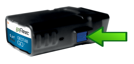
The IOX functions on a basic principle. Each IOX performs a simple task and relays information to and/or from the GO device. An IOX connects to the GO device using the specialized mini USB port found on the side of all GO6 and GO7 devices, and it’s easy to set up and connect. While some IOX expansion products require the install be done by a certified installer, others can be connected to the GO device and easily installed on your own.

IOX-Expansion-Port

A number of different components can be measured by the IOX hardware and can be customized to meet a fleet’s specific use. For example, a fleet that relies on a dispatcher to organize and direct drivers can see a lot of benefit in using the IOX-GARMIN line, which can push messages and routes to the GARMIN to quickly advise the driver of the next stop on the route.

Types of IOX Expanders

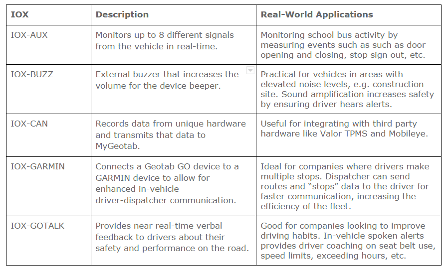
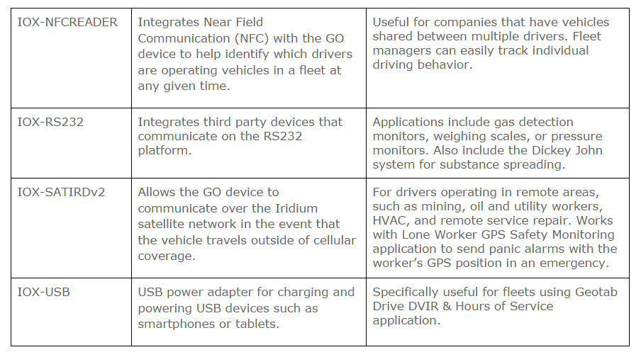
More detailed information on IOX Expanders can be found on the Geotab Marketplace.

IOX-table-1

IOX-table-2

Fleets that measure a number of different metrics for their vehicles, or ones that use third party products from which data is recorded, can benefit from the use of the IOX-CAN. The IOX-CAN allows fleets to record data from unique hardware and transmit that data into MyGeotab. Geotab also uses this IOX to support partner integrations, such as Mobileye for Driver Distraction Systems and Valor for TPMS (Tire Pressure Monitoring Systems) and Reefer Monitoring (Temperature Monitoring).

Some other great IOX Expanders include the IOX-BUZZ; it’s an external buzzer for the GO device that raises the volume of the device beeper to make it easier for drivers operating loud engine vehicles to hear audible alerts. The buzzer will sound when driver feedback or rule based audible feedback is configured within MyGeotab. The IOX-USB is great for powering USB devices like tablets and smartphones in Geotab Drive applications, whereas the IOX-NFCREADER can be used to identify the driver operating a specific vehicle using our specialized NFC keys.

One of the most powerful IOX from Geotab is the IOX-AUX. With this IOX a fleet can measure four inputs (up to eight with two IOX-AUX). Essentially, the IOX-AUX is connected to a signal that enables a fleet manager to monitor a variety of vehicle inputs such as sirens for emergency vehicles, refrigeration units, and seatbelt sensors. Using an On/Off built-in logic, the GO device can pick up a change in state of an object and attribute it as a signal. Then this information is sent to MyGeotab where it can be used in conjunction with the powerful Exception Rule logic in MyGeotab to create relevant and strong conditions and metrics for fleet vehicles.

How the IOX Works

The GO device uses the pre-programmed firmware to intelligently detect the IOX that is connected. Then, it adjusts the logic on a device level to account for the new IOX and the data that may be sent/received. While some IOX read information only, such as the IOX-AUX, others can actually push information as well, like the IOX-GARMIN.

Once the device is able to configure itself to receive the specific IOX information appropriately, it will start logging and transferring the data to MyGeotab. This process can take up to a couple of minutes. Some IOX transfer information as soon as the data is received, such as state changes for IOX-AUX or when drivers swipe their keys on the IOX-NFCREADER. Other IOX transmit information similar to GPS and speed data at regular intervals based on the logging algorithm.

IOX Expandability

The IOX is further expandable and up to five can be connected in series to one GO device. If a fleet requires multiple IOX, each supports further expandability using the in-line port with a termination shunt inserted upon shipment. Once the termination shunt is removed and the secondary port exposed, additional IOX can be connected to a total of five on one device. Essentially, fleets are getting six devices working independently as well as together to deliver a wide range of information to the equally powerful myGeotab web application.

The Future of IOX

Geotab has plans to extend the IOX line in the future. One such example is the IOX-GOTALK. GO TALK is a new product that provides real-time verbal feedback to drivers on their driving habits and performance en route. It can be configured to speak a number of pre-programmed notifications. Unique customized notifications can also be created to have the GO TALK speak different statements. Keep an eye out for other new and exciting IOX hardware down the road!

go-talk-pr-image-sept-8

IOX Hardware Learning Resources

By providing more intelligent hardware, intricate firmware and feature packed software, the GoFleet and Geotab product line has evolved into an ecosystem of its own. The IOX is a simple, yet powerful, aspect of this system as it provides much of the data that is used by other components, like MyGeotab and the excellent SDK. With the data provided to our clients, fleet managers can create reports and rules in MyGeotab, harnessing the full potential of the Geotab fleet management solution.

Original Article By: Taimoor Khan, Technical Services Engineer
https://www.geotab.com/blog/iox-expansion/