Telematics in dangerous sectors

How Telematics Comes Into Play In Dangerous Sectors

In any industry, workplace safety is of critical importance. Industries where contract workers are hired by authoritative management corporations to complete tasks in dangerous sectors, often find themselves looking at how they can improve safety measures.

As many tasks in these fields require the use of heavy machinery or the movement of large and hazardous items – many are looking at how telematics advancements can help.


Hiring In Dangerous Sectors

To fully understand the need to implement safety measures via telematics, the hiring process must be understood in dangerous sectors such as construction, transportation, forestry or logging and even mining and oil. In these industries, businesses often outsource work by hiring contractors rather than hire full or part-time workers. There are number of reasons why:


Productivity and Finances 

Often in these dangerous sectors, this type of work is seasonal. This means that workers are only required at certain times of the year. Corporations prefer the flexibility of outsourcing work, so they do not have to deal with the administrative challenges of constantly having to layoff workers at the end of each busy season.

Corporations understand the massive financial benefits of outsourcing to contractors. Operations managers discovered that by hiring seasonally, they can perform cost comparisons in terms of productivity and pay for all workers.

They are able to perform such comparisons during the season to monitor and re-hire the best-performing contractors. As a result, corporations can maximize their productivity and revenues, allowing them to remain competitive in an aggressive marketplace.


Reduced Liability  

By outsourcing work and hiring seasonal contractors, many corporations also find that they can improve their liability risk. This enables their business to be more focused on supplying the proper safety requirements, while the actual need to carry out safe work practices are shifted to a  constructor or general contractor who undertakes ownership of the project.

It is important to highlight that corporations will be required to ensure safety in the means of: (i) ensuring proper training is available; (ii) all workers and supervisors are properly trained on safety policies or precautions; (iii) have the appropriate safety tools; or (iv) the proper equipment and safety environment to protect the workers.

This means that the constructor is responsible for ensuring that all workers on site are complying with safety policies, procedures and obligations – or inadvertent liability.


Risk Evaluation and Assessment: Onsite and Offsite 

In sectors where authoritative management governs worksites, the concern of safety does not end there. There are risks when workers are moving supplies or travelling between sites. When risk is evident in numerous locations at varying times, the need to collect and analyze data to evaluate risk becomes even more critical. 


Onsite Risk

Onsite risks are typically limited to the immediate actions of contractors. Often this refers to the knowledge of training and precautionary measures taken by workers while completing tasks. For example, knowing how to safely harvest timber and load lumber into the flatbed of a truck with the use of heavy machinery. When proper training and undamaged tools or equipment is utilized, the onsite risk is significantly lowered.


Offsite Risk

In comparison, offsite risks are factored-in to the immediate actions of contractors – as well as their working environment. As much as offsite risks arise when goods are being transported, contractors must be attentive to their surroundings. A wide range of unpredictable incidents can happen at any job site – including injury, road clean up and even lost resources.

A business can mitigate the risks by having pre-trip checks on the vehicle or implementing tools to ensure that strict safety protocols are being followed.


How Authoritative Management Can Reduce Risks

To properly reduce risk and liability concerns, fleets in these dangerous sectors must investigate risks and assess danger in the field. To better understand current initiatives and procedures, companies must evaluate key historical safety indicators – which will shed light on how efforts may need to change.   

In order to fully understand your current KPIs and solutions framework, a telematics assessment should be performed. It’s important to note that while solutions may have several advantages, it is critical to understand how the solution will specifically target safety.

There are three options that can be implemented in industries that are dangerous or hazardous for its workers.


1 Sensorizing Your Fleet 

Installing sensors throughout your fleet can minimize risk as the devices can act as a safety precaution. Since the technology transmits various data internally, many corporations have found sensors to be useful for the following: displaying real-time GPS location, displaying alerts or notifications and confirming weight or load requirements.

When sensors are installed onto equipment or vehicles, teams can know the exact movement of the asset it is attached to, in addition to certain compliance requirements that may need to be met – such as weight or load. However, one important use to highlight is the alert system for trip inspections, as the sensor can convey whether certain safety precautions are faulty. This means that unsecure lids or caps, loose straps, completed walk around checks or even whether a contractor has the proper training on file to use certain equipment can be detected. 


2 Increased Visibility With Cameras 

Cameras can be installed throughout fleets to monitor the use and performance of vehicles and heavy equipment. Not only can this record the events in view of the device, such as general employee safety on site, but it detects whether contractors are using the equipment properly while moving between two points.

The most important feature of using the cameras, however, is to perform incident reviews when there is an accident, reported issue or complaint of delay. By having footage readily available, site managers are able to review what happened rather than rely on worker or civilian recollection. Meaning proper actions like additional training, suspension, or understanding of liability and fault can happen. 


3 Safety Scoring And Training Integrations 

As previously mentioned, cameras can be used to help shed light on more training opportunities. Specifically, equipment use via engine monitoring and camera surveillance can be used to determine safety scores for each worker. This allows for performance ratings to be completed and even allows for training or site suspension to be assigned based on the person’s skills or knowledge of procedures.


Use Case: Forestry and Logging 

To ensure safety in a high-risk sector like forestry, many authoritative corporations are implementing telematics solutions throughout their operations. Such telematics solutions include the three previously discussed tools: sensors, cameras and scoring or training systems. 

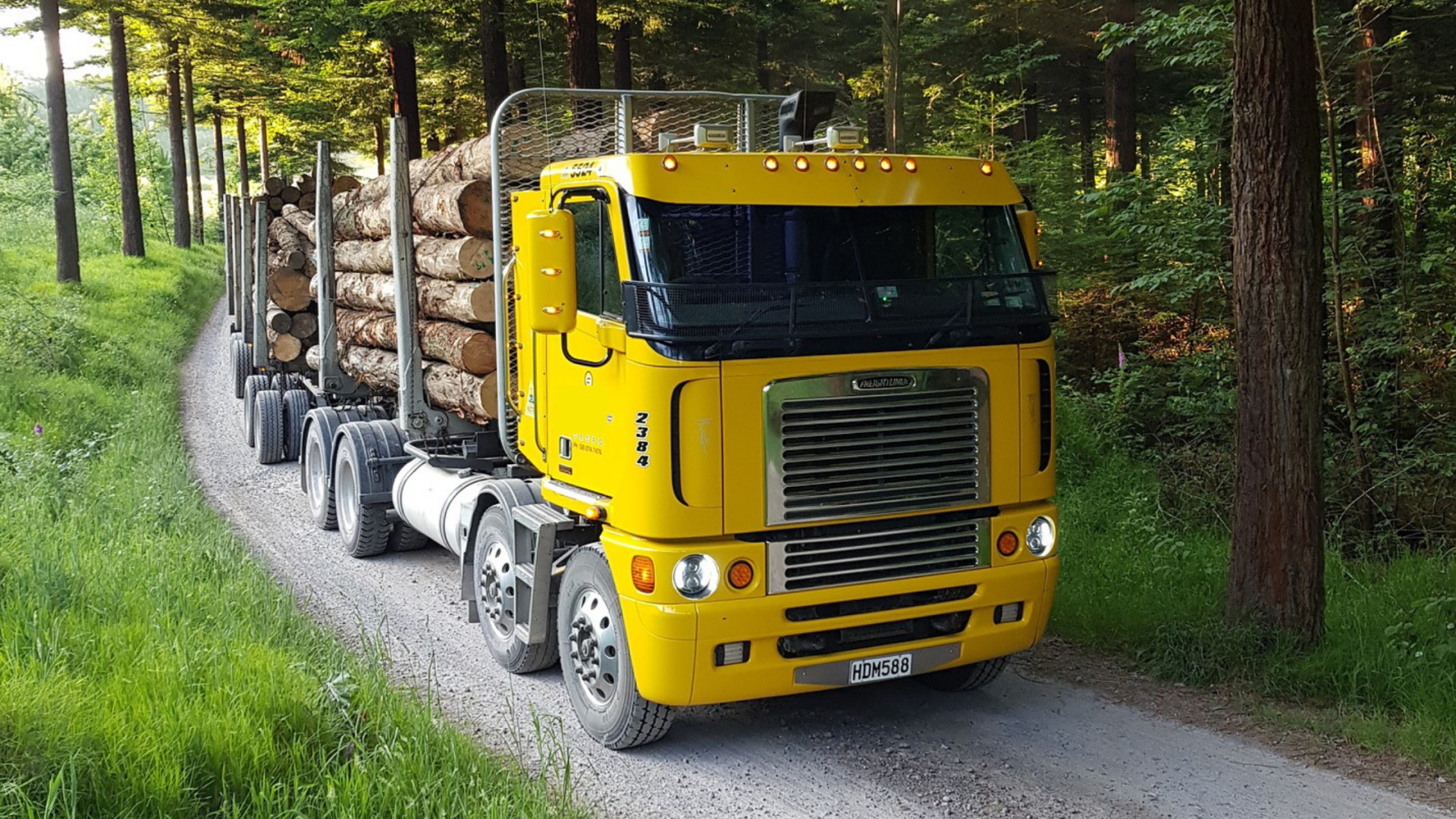
By sensorizing fleets, corporations in logging are able to ensure that certain actions are always taken and even set up alerts to notify workers when certain actions were not taken. This is specific to the loading process on a logging site when lumber is placed on flatbed trucks to move it to the millsite. Since these vehicles are moving thousands of pounds of lumber, if straps are not secure, cargo can find its way off the vehicle while on route. If this happens, regardless of whether it is on public or private roadways, death and injury of a bystander becomes a real concern. 

Fleets that install cameras on vehicles and heavy machinery find that they can better monitor the behaviour of employees – focusing on whether individuals are acting safely by following procedures. This enables companies to flag safety concerns. Such concerns include insecure loads being dispatched or contractors forgoing pre-trip checks. 

Cameras are also useful when offsite vehicles can sometimes be involved in accidents involving civilians, such as accidents with other vehicles or dangerous driving. Verifying what really transpired by reviewing the driver footage can shed light as to what truly happened and who was at fault. It can also provide a resolution framework as incidents are documented and structural changes are made to rectify them

Lastly, all of the information collected on employee behaviour can be reviewed and submitted into a scoring system. Meaning managers can see who is following safety protocols and who may need additional training.

To learn more about how telematics is being used right now, check out our recent success story that features Forest Trotter by clicking here.
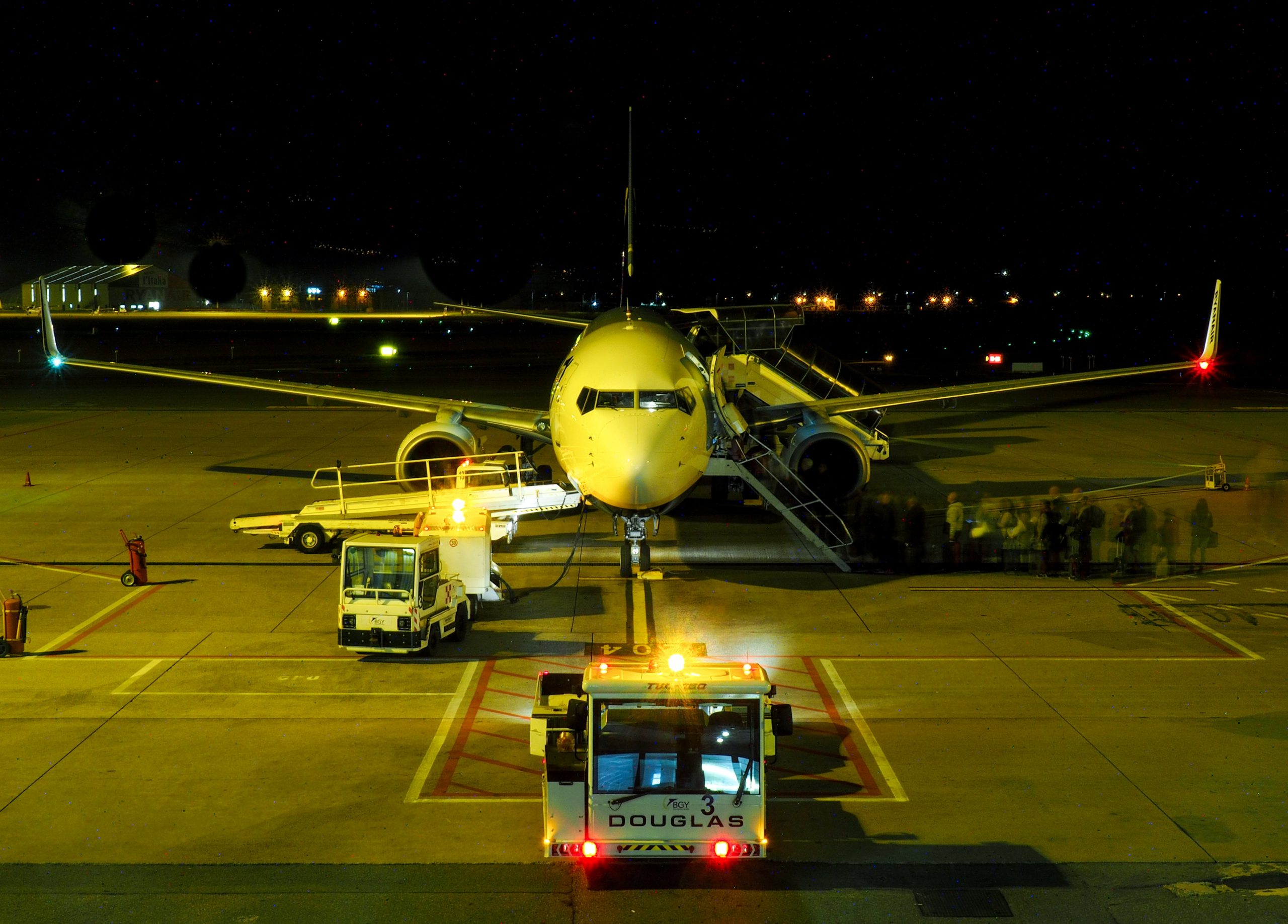
 

Operational congestion occurs in highly localized environments such as airports

Part I: More People Are Affected By Operational Congestion Than You Think

The backlog of stationary assets can result in operational delays, lengthy completion of tasks and will add additional costs to projects. If we focus on the costs of congestion, one thing becomes clear – the ongoing costs are too much to bear for businesses. 

Below we discuss how congestion in business operations, where environments are highly localized, must be addressed to reduce operational losses. As well how this affects airport resource management. 


Where Congestion Is Not Yet Understood

When the general public thinks of congestion, they think of the travel delays between two points during high-demand times or peak hours. However, it is important to emphasis that congestion happens way more than you think and is not limited to the roads during rush hour.

Operational congestion occurs in highly localized environments such as airports and warehouse distribution hubs. These environments often have few routes available for transportation and there is limited data collected about the movement of assets. With few route options and limited data – congestion is bound to occur.

While some delays are inevitable in these environments, allowing it to continue for too long is too costly for businesses to ignore. If businesses focus on the costs of grid locking and backlogs, they will find that many resources are wasted as staff are unable to maintain a steady workflow. Such delays cause a ripple effect and can adversely affect customer relations – as customers become frustrated standing in long waiting lines.

In comparison, non-localized environments (what much of the public encounters when travelling on highways or city streets) have data sources available to help alleviate congestion. Sources like Google Maps has been implemented to collect, display and analyze congestion information on an ongoing basis and in real-time to the masses. 

In fact, this flow and analysis of information has inspired operation managers to be specific in how and where they want to reduce operational congestion in localized environments. 


Congestion In Airports

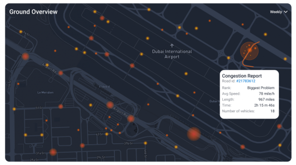
With thousands of assets moving daily – highly localized environments like airport grounds are a prime example of where congestion can be found. With constantly moving assets, airport operations have a goal to optimize flow of traffic, reduce gridlock and lower wait times of assets in detention. 

To properly stop asset detention, an entire framework of what congestion is in an airport environment must be understood by equipping assets with various telematics solutions. By using connected sensors to see how equipment is being used, as well as GPS tracking to note the location and speed of vehicles – businesses can gain proper visibility into operations. Doing so will allow for assets to remain in movement, shortening servicing turnaround time and as a result, increase revenue.


The Repercussions of Congestion In Airports And Airport Resource Management

Airports cannot afford to allow congestion to be ongoing. Not only does it cause for asset detention or the pause of asset movement, but it results in a myriad of issues: 

  • Overall fleet performance will drop as work is at a standstill 
  • Some operations are at risk for being charged for the waits
  • Heavy financial losses are experienced as employees are paid even if work cannot be performed – causing a potential spike in higher ticket prices
  • Resources are wasted when equipment or vehicles are idling 
  • Passengers suffer lengthy delays when travelling 
  • Attention to detail and safety decreases as staff rush to complete tasks to stay on time  

It’s important to note that these repercussions of operational congestion may seem specific to airports, but very similar issues can be noticed in other highly localized environments. Distribution hubs, for example, are seen to encounter very similar productivity, financial and consumer effects. 


Triggers of Congestion

Airports are highly localized as there are few roads that thousands of assets must utilize at predetermined speeds. Since there can be numerous assets such as refuelers, tugs and tractors, water trucks, passenger boarding steps and more servicing, each aircraft – from the second it lands to moments before it takes off – can contribute to congestion. 

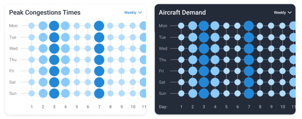
The problem of congestion is compounded when aircrafts take off and land every few minutes – meaning that they must undergo routine aircraft maintenance by servicing crews. This causes longer than necessary turnaround times, especially during high-traffic and peak times. 

Part II: The Solution To Operational Congestion – A Congestion Management Strategy

Cellular Asset Trackers: Don’t Make The Mistake Of Investing In The Wrong One

There are so many cellular asset trackers in today’s markets for fleet managers, that things can sometimes seem overwhelming. How do you know which hardware you need to buy or how you can get the best value out of it? We will be discussing the different hardware devices for various fleet management needs and the scenarios in which fleets can use each device.


Cellular Asset Trackers? Why Not Satellite Asset Trackers or BLE Beacons?  

When speaking about asset trackers, there are many options available. However, the way they differ from each other initially is based on how the device transmits information. 

  • Cellular asset trackers use cellular network coverage to transmit data and information about an asset. As coverage varies based on specific locations, assets using these trackers that enter no coverage zones will not be able to transmit data.
  • Satellite asset trackers use satellite connectivity to transmit data about an asset and can be the more reliable option if your asset is travelling out of cellular coverage.
  • BLE beacons have pre-requirements (like asset trackers or BLE readers) in order to transmit data and information about an asset or group of assets.


Below we discuss 6 cellular asset trackers that are available, and how their features differ.


6 Top Performing Cellular Asset Trackers 

Flex Solar Asset Tracker 

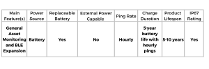
The Flex Solar Asset Tracker is an asset tracker that syncs with MyGeotab and works similar to a Geotab device as it allows the tracker to be visible on a map. The tracker is solar-powered and is utilized primarily for the general tracking of bulk cargo containers, vehicles and other large assets that may not have a direct power supply – thus requiring solar energy. The ability to power the device through environmental conditions is critical as certain large assets that are travelling far distances or are being stored outside for long periods of time (like shipping containers) are often standalone assets with no power connections. It should be noted that a full charge can allow the Flex tracker to last up to 4 months with multiple pings per day. It’s also important to note that this tracker can be expandable for door sensing, temperature probing and tire pressure tracking.

Use-Case: How Long-Haul Transporters Are Using Flex Solar

The Flex Solar Asset Tracker is praised for its ability to remain powered with solar energy. Meaning, businesses no longer have to worry about removing trackers to replace batteries. Instead, they only rely on the sun to power the device so data about the asset tracker can be transmitted. This is particularly useful for commercial transportation fleets who conduct long-haul deliveries. As the device can continue to charge and transmit information via the sun, the asset tracker can always send real-time data. Typically, this solar power feature is praised by those who enjoy a ‘set-it and forget-it’ device, or for those who are looking to take advantage of renewable and free sources of energy.


Blackberry Radar

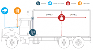
The Blackberry Radar device focuses on asset tracking for cargo, more specifically, for vehicles and non-motorized assets like bulk containers, trailers and various equipment where content quantity needs to be monitored. The tracker is unique as it requires a specific installation to allow for its radar feature (which analyzes the quantity of cargo within a container or trailer) to be used. Once the device has been placed at the predefined orientation, it can analyze the content capacity of the asset it is attached to. This is explained as acting like a camera that measures how much cargo is present. Having a radar function like this is new and allows for users to complete better planning as there are more accurate (and visual) load-stats available.

Use-Case: How Delivery Vehicles Are Using Blackberry Radar 

As previously mentioned, the Blackberry Radar tracker allows for radar sensing and load analysis of the quantity of content within an asset. Meaning, users can see exactly how much is within a trailer, truck or container in real-time. This radar tracker is particularly useful in delivery fleets who constantly receive new delivery requests. Using this tracker allows dispatchers to analyze and review the content quantity of each delivery vehicle. Essentially judging which vehicles are full and whether near-empty vehicles have enough space to pick up additional deliveries to complete that day.


Remora2

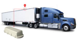
The Remora2 tracker is utilized for general asset monitoring and has expandability opportunities with BLE beacons. As the tracker uses a Bluetooth 5.0 gateway, which allows it to communicate with other local asset tags to report on them, it is the ideal investment if you will later need to invest in various BLE beacons. As a standalone device, this tracker is similar to the Flex tracker that was mentioned previously as it allows for general location tracking. However, what differentiates itself from the Flex Solar tracker is that it has an ion battery. Meaning, depending on where an asset will be stored or used most of the time, having a battery option may be the more powerful and reliable choice. As well, when compared to the Solar Flex, it’s important to mention that it is the cheaper option as there is no solar-power technology required. It is also important to note that the Remora2 device has an anti-theft mode, tamper detection, is geo-fence aware, and functions as a 3rd party device on MyGeotab.

Use-Case: How Commercial Transportation Fleets Are Using Remora2

Similar to the Solar Flex tracker, the Remora2 tracker is typically used within fleets who are conducting long-haul deliveries that require more pings daily or are spending some time in a location where solar changing is difficult. Meaning, having an ion battery rather than a solar-powered battery would be the more reliable option to suffice reporting needs. 


Falcon 

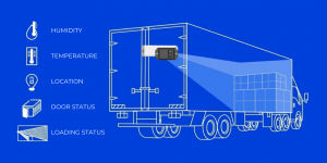
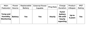
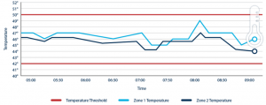
The Falcon device is a temperature-sensitive tracker which allows for fleets to monitor temperature and humidity. The device embodies a 5-year battery life with hourly reporting so users have continuous monitoring of temperature-sensitive cargo. Similar to the Remora2 device, the Falcon device has an anti-theft mode, tamper detection, is geo-fence aware, and functions as a 3rd party device on MyGeotab. 

Use-Case: How Food Transporters Are Using Falcon 

When tracking goods that are sensitive to temperature and humidity, the Falcon is the go-to tracker for many fleets. Since the device focuses on allowing users to monitor the environmental conditions of containers, trailers, trucks and more, it’s the perfect tool to use when moving food products. As improper storage is not an option for food products as it can lead to spoilage, the Falcon tracker can monitor the temperature and humidity of the location where food products are stored to ensure that conditions meet strict regulations. Forgoing a device like the Falcon leaves food transporters at risk for being found incompliant as there are numerous rules  regarding the proper storage and handling of frozen food, fresh produce and meat products to keep consumers safe. 

advantages-temperature-monitoring


Sensoneo Bin Fill Level Sensors

Sensoneo Bin Fill Level Sensors are a smart, enterprise-grade waste management solution that focuses on monitoring waste content quantity. The sensor is a robust device that can withstand harsh conditions such as water and is shock resistant which is perfect for its use in waste management. Sensoneo focuses on allowing fleets to remain efficient and optimized as it monitors how full a waste bin is, alerting users when the bin is approaching capacity. Additional features of the device include; Bluetooth, pick-up recognition, temperature measurements, fire alarms, and overturn alarm options. 

Use-Case: How Waste Disposal Fleets Are using Sensoneo 

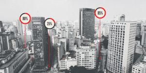
Sensoneo is leveraged by waste disposal fleets who empty waste bins. Typically, the device is attached to a specific bin to monitor how full the container is getting overtime, alerting users of when it is near-full and needs to be emptied. When the tracker sends an alert about the quantity level, fleets can create a route that only visits the bins that are full or are at least 80% full – passing bins that are less. Doing this helps to ensure that time is not wasted visiting bins that do not need to be emptied so work is optimized and resources can be saved. 


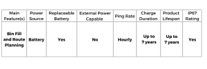
A Cellular Asset Tracker Cheat-Sheet

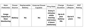
When it comes to cellular asset trackers, there are numerous devices available that any business can use and sometimes, their features can become confusing. To help businesses better understand what their cellular tracker options are, we created a feature comparison chart below based on our analysis above.

Still unsure about what cellular tracking device may work best for you, or would like to learn more about a specific tracker? Contact us today so we can set up a time to chat about your unique needs. 

Aviation and Ground Service Crews Taking Advantage of Telematics

The merging of telecommunications and informatics seems to be an ever-evolving sector as it continues to impress business owners across various industries. While it may be apparent of how it’s used for location tracking and maintenance monitoring in the trucking and logistics sector, it’s time to highlight its use in aviation. Similar to other industries, leading aviation and ground service crews use the technology in ways similar to fleet managers as the outcomes are as equally beneficial. 


Where Did Telematics Originate From?


When telematics technology was first being developed in the 1960s, it was initially used by the U.S. Department of Defense to aid in the position tracking of varying assets in addition to being a way to improve communication on the battlefield. However, as time continued and the technology evolved, leaders in other industries saw the potential of telematics elsewhere. When discussing airports and aviation, focus is greatly on the GPS tracking, asset monitoring and communication features.


Below are two examples that speak to the beneficial outcomes that resulted from aviation and ground service crews investing in telematics on runways. 


Why Aviation and Ground Services Continue to Implement Telematics Technology


Ensure Cost-Effective Utilization & Efficiency 


When large quantities of data are collected in real-time, immediate decisions can be made. That is especially true when airports utilize telematics solutions for the purpose of resource management and productivity. From monitoring fuel usage to asset location, beacons and sensors can be installed to track nearly every aspect of aircraft operations. Ultimately allowing officials to allocate employees and equipment properly to achieve maximum productivity, as well as being able to monitor and report on their efforts. 


A common and well-known example of this is allocating vehicles to complete tasks in relation to proximity and location. Meaning, when a specific type of vehicle is requested, officials can deploy an available vehicle that is closest. Allowing for fuel, physical resources as well as personnel to be used efficiently. If GPS tracking was not used, airports would risk sending vehicles that are much farther than others, causing them to waste time and resources. 


This is evident when deicing vehicles are required to spray aircrafts with a mixture of hot water and propylene glycol during the winter months. If a deicing vehicle is requested, it’s important to not only send the closest vehicle to the aircraft, but send a vehicle that has enough of the deicing fluid to complete the job. Both of these requirements are trackable by custom telematics solutions. However, when telematics technology is not used, airports risk using additional and unnecessary resources or equipment. This is simply because they were unaware and unable to track the most efficient way to complete the assigned task.


Verify Safety Protocol 


Telematics solutions are also highlighted as a means to increase and maintain safety within certain industries. This is true within the aviation sector as technology can not only be leveraged to track both employees and assets but to ensure safety protocol is followed. 


An example that highlights telematics technology aiding in the safety of aviation teams is how the technology can be used to track the efforts of employees on runways. Meaning, managers and officials can always have real-time updates about where individuals are located. So if they see that an employee is operating a vehicle in an unauthorized zone, they can make communication not only with the individual in the unauthorized zone, but with others around them to stop any activity that may accidentally harm the individual. Additionally, telematics can be used to track the driving behaviours of employees using company vehicles as many airports require drivers to authenticate who is in the driver’s seat. Meaning, sharp turns, speeding, or other dangerous behaviours can be recorded, addressed and monitored. Allowing for accidents and incidents on runways as well as the surrounding property to be drastically lowered. 


For more information about telematics and government services, visit: https://stagingms.gofleet.com/government-services/airport/


The GoFleet Experience

To successfully implement a telematics solution, airports must feel confident about integrating a platform that addresses their full system. This includes ground handling, airlines, and airport authorities so true transparency and visibility can be accomplished. If you’re interested to learn more about how we can help provide a true 360 solution of complete management for any industry, contact us today!