On August 10, 2020, the Commercial Vehicle Safety Alliance (CVSA) announced that their International Roadcheck is rescheduled. The new date announced was September 9 – 11, 2020. Since this date is quickly approaching, it is critical for all commercial vehicles on the road to reassess and ensure compliance with federal regulations.
As many fleets are just beginning to return to near normal productivity or are just returning to the road after pausing work after the COVID-19 pandemic, compliance must remain a priority.
What Is The CVSA’s International Roadcheck
TheInternational Roadcheck is a thorough inspection of commercial vehicles on the road. These inspections are conducted over a 72-hour high-volume period and enforcement is conducted by inspectors in Canada, Mexico and the U.S. Inspections will be conducted in a variety of settings – in mobile patrols, at fixed locations and weight, or at inspection stations.
What Will Be Checked?
In Canada, law enforcement personnel will conduct motor vehicle and driver inspections. They will leverage standard out-of-service criteria in North America, the National Safe Code and other provincial or territorial regulations to note violations to vehicle or driver compliance.
In the U.S. inspections will use Federal Motor Carrier Safety Regulations in addition to rules and regulations that are applicable to the commercial motor vehicle sector.
Similarly, in Mexico inspections will review regulations and standards set by the Mexican government.
While this is not a complete list, here are some important reminders for drivers to have easily accessible while on the road:
Have ELD documentation ready with a proper understanding of how to display it
Ensure there are blank paper logs available within the vehicle (it is recommended to have at least eight days worth)
Have any and all malfunctions properly notes
Ensure unassigned driving time is annotated or claimed
Wear seat belts
Remain professional with inspectors
Keep vehicles clean and tidy
Drivers should also have their driver’s license, skill performance evaluation certificate, medical examiners certificate, driver’s record of duty status, as well as any other supporting documentation that may be relevant.
Looking for more information on how to keep your fleet compliance to strict industry standards? Contact us today – we’re trained and experienced in finding effective solutions to target nearly any need.
Most fleet managers have had a driver get into an accident at some point and dealing with the fallout can be maddening. It’s often difficult to know exactly what happened, and fleet managers want to trust their driver’s explanation, but that can be difficult to do in light of competing evidence.
The best thing for any fleet manager is to have eyes on the situation.
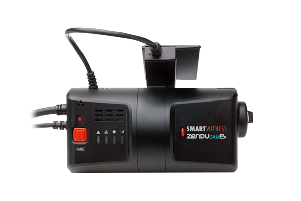
Luckily, there’s ZenduCAM; a commercial vehicle camera system that can address this problem. ZenduCAM integrates Smartwitness and MyGeotab to provide a flawless dual dash cam with GPS.
SmartWitness is a British company that utilizes technology it has developed in the UK, USA, and South Korea to lead the world in designing and manufacturing in-vehicle cameras. The company claims its equipment is in 200,000 vehicles around the world, driving 35 million miles per day. SmartWitness cameras have 170 degrees field of view to capture the entire front and peripheral views of a vehicle, and additional cameras can be installed to capture driver behavior and blind spots. The cameras can include microphones for audio recording to record driver behavior and the cameras also operate automatically and are resistant to tampering.
How do vehicle camera systems work?
The SmartWitness commercial vehicle camera system can be integrated with numerous other systems, including brakes, reverse, horns, taxi meters, stop arms, door locks, and more. GoFleet integrates SmartWitness cameras with the Geotab telematics system in order to maximize their benefits. Geotab utilizes GPS sensors to provide second-by-second tracking of a vehicle, including when the ignition is turned on, the trip distance and time, driving speed, and time spent idling. GoFleet collects all this data into one easy-to-use interface to give fleet managers a clear picture of what is happening at any given time, and that includes integrating the Geotab data with any number of other monitoring systems.
Integrated Vehicle CCTV Systems
Our integrated commercial vehicle camera system allows fleet managers to monitor fleet activity via live video streaming in desktop browser or mobile device. The cameras record the events surrounding an accident and that footage can be integrated with data from other sensors, in particular speed and braking. The combined data can usually clearly show who is at fault. This can protect against false accusations and fraudulent insurance claims.
ZenduCAM helps with a lot more than just accidents. The commercial vehicle camera system can be set to record entire the time before and after certain events. Examples of negative events that a fleet manager may want to record include speeding, idling, hard acceleration, and harsh braking. Fleet managers can set rules, like a maximum speed limit, and anytime those rules are violated the ZenduCAM system can automatically send footage of the violation to the fleet manager’s attention. This can greatly reduce disputes between drivers and managers. For example, a driver might claim that he was speeding just to pass another driver that was driving unsafely slow. The footage of the speeding event will usually either confirm or disprove the driver’s story. This video collected on driver behavior can be used to both proactively coach good driver behavior or be used to discipline bad drivers.
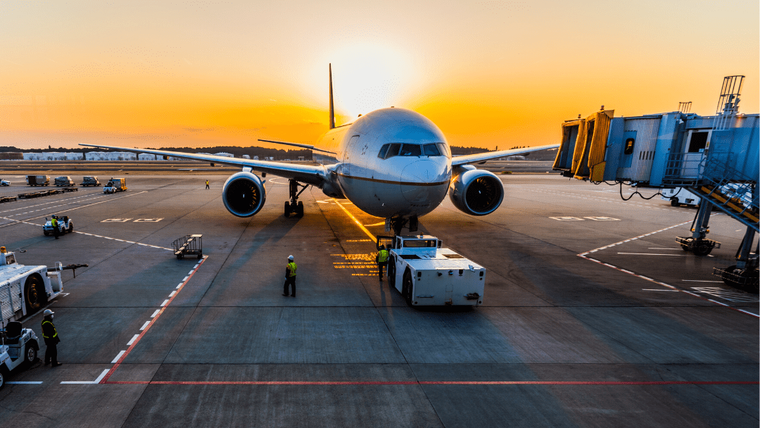
The merging of telecommunications and informatics seems to be an ever-evolving sector as it continues to impress business owners across various industries. While it may be apparent of how it’s used for location tracking and maintenance monitoring in the trucking and logistics sector, it’s time to highlight its use in aviation. Similar to other industries, leading aviation and ground service crews use the technology in ways similar to fleet managers as the outcomes are as equally beneficial.
Where Did Telematics Originate From?
When telematics technology was first being developed in the 1960s, it was initially used by the U.S. Department of Defense to aid in the position tracking of varying assets in addition to being a way to improve communication on the battlefield. However, as time continued and the technology evolved, leaders in other industries saw the potential of telematics elsewhere. When discussing airports and aviation, focus is greatly on the GPS tracking, asset monitoring and communication features.
Below are two examples that speak to the beneficial outcomes that resulted from aviation and ground service crews investing in telematics on runways.
Why Aviation and Ground Services Continue to Implement Telematics Technology
Ensure Cost-Effective Utilization & Efficiency
When large quantities of data are collected in real-time, immediate decisions can be made. That is especially true when airports utilize telematics solutions for the purpose of resource management and productivity. From monitoring fuel usage to asset location, beacons and sensors can be installed to track nearly every aspect of aircraft operations. Ultimately allowing officials to allocate employees and equipment properly to achieve maximum productivity, as well as being able to monitor and report on their efforts.
A common and well-known example of this is allocating vehicles to complete tasks in relation to proximity and location. Meaning, when a specific type of vehicle is requested, officials can deploy an available vehicle that is closest. Allowing for fuel, physical resources as well as personnel to be used efficiently. If GPS tracking was not used, airports would risk sending vehicles that are much farther than others, causing them to waste time and resources.
This is evident when deicing vehicles are required to spray aircrafts with a mixture of hot water and propylene glycol during the winter months. If a deicing vehicle is requested, it’s important to not only send the closest vehicle to the aircraft, but send a vehicle that has enough of the deicing fluid to complete the job. Both of these requirements are trackable by custom telematics solutions. However, when telematics technology is not used, airports risk using additional and unnecessary resources or equipment. This is simply because they were unaware and unable to track the most efficient way to complete the assigned task.
Verify Safety Protocol
Telematics solutions are also highlighted as a means to increase and maintain safety within certain industries. This is true within the aviation sector as technology can not only be leveraged to track both employees and assets but to ensure safety protocol is followed.
An example that highlights telematics technology aiding in the safety of aviation teams is how the technology can be used to track the efforts of employees on runways. Meaning, managers and officials can always have real-time updates about where individuals are located. So if they see that an employee is operating a vehicle in an unauthorized zone, they can make communication not only with the individual in the unauthorized zone, but with others around them to stop any activity that may accidentally harm the individual. Additionally, telematics can be used to track the driving behaviours of employees using company vehicles as many airports require drivers to authenticate who is in the driver’s seat. Meaning, sharp turns, speeding, or other dangerous behaviours can be recorded, addressed and monitored. Allowing for accidents and incidents on runways as well as the surrounding property to be drastically lowered.
To successfully implement a telematics solution, airports must feel confident about integrating a platform that addresses their full system. This includes ground handling, airlines, and airport authorities so true transparency and visibility can be accomplished. If you’re interested to learn more about how we can help provide a true 360 solution of complete management for any industry, contact us today!
A satellite tracking system is the ultimate device to manage your mobile resources whenever and wherever they go.
GoFleet’s satellite tracking system supports your assets in the field, whether it’s a container or trailer. Our easy to install system features no wires or antennas and can be placed within the asset with either industrial adhesive or a screw mount. Tracking your assets has never been easier.
The satellite tracking system provides fleet managers with pin-point accuracy for location information and activity information. Our system provides updates hourly while your asset is in continuous motion and daily when it has stopped. This powerful information can be used to keep you informed about how your assets are being handled and identify any issues that may arise.
GoFleet is Your Eyes in The Sky
How it Works
Keeping up with the latest in technology, we use a military grade Smartone LP powered by a AA Lithium Battery pack to keep conntected to the satellite network. This allows our GPS units to perform under the toughest conditions so your fleet and assets can operate almost anywhere. The smartone unit can still operate in temperatures as low as -40° to as high as +85°. The system will even send you alerts when the battery levels are low. You can sync as well with cell phone tracking or our fleet tracking so you can integrate all of your systems together.
The Power of Data in Satellite Asset Management
Data collected from our satellite fleet tracking system is vital to reducing costs by damages, or delays in transit. Knowing exactly where all of your assets are in the field covers you and your fleet from errors and track performance long term. Identifying choke points in your processes or knowing when an asset has been idle for too long can help add to your bottom line.
Let GoFleet’s system help you!
Get pole to pole, round the globe coverage and reliable intelligence with GoFleet’s live satellite tracking system. Our support team is eager to answer your questions and help you get the most value out of our systems. Contact us for more information and start saving.
Switching from one ELD or telematics provider to another is not the easiest process. However, if you are having issues with your current provider, sticking with them simply because you are worried about making the jump isn’t good either. Once you’ve reached a decision, it’s important to ask the right questions to reduce the pain of switching and prevent any surprises. In this blog we will go over best practices when transitioning from one provider to another.
Investing in telematics for your fleet can be a significant undertaking. Before the final decision is made regarding which telematics provider to choose, there are usually countless demos, meetings, negotiations, and approvals. Once the vendor is chosen, there are then a new set of tasks that need to begin: planning out a telematics strategy, ELD implementation, and most importantly – measuring results.
Why Make the Switch
Almost all customers who implement telematics goes through a similar process. For some, it’s smooth sailing, unfortunately for others, it can be a little more complex. Regardless of how the process goes, customers often stay with their existing telematics provider for a variety of reasons:
Long-Term Contracts
Comfort Level
Capital Expenditures for Hardware
Back-End Integration
With that being said, sometimes there are compelling reasons why fleets decide a change is necessary – even if it requires a little extra work. The decision to change providers is normally sparked by a few reasons: ongoing hardware costs, reliability, technology, security, or monthly fees.
When vetting out potential partners it’s crucial to take several factors into consideration to make the best decision. The top four criteria to evaluate are: technology, access to data, partnerships with third-party partners, and security.
Evaluating ELD Providers: What to Look For
From a technological perspective, changing telematics hardware and software is often one of the most difficult pills to swallow. Significant investment was already made obtaining the devices, installing and maintaining the devices, and the education internally on how to use the system. Switching from one provider to another requires removing the old devices, installing now ones, and retraining your staff on how to use the new system.
No telematics company can eliminate all the pain of switching providers – however, it’s important to choose someone who is willing to work with you to reduce this pain as much as possible.
Telematics companies today receive data from the devices they sold to the end user. Some of these devices are proprietary and only specific to the provider who sold them. Some other devices are off-the-shelf meaning they are capable of sending data to other sources other than the initial telematics providers software platform.
1. Third-Party Device Integration Speeds Up the Transition Process
Make sure to ask providers about third-party integration (meaning the ability to pull data from a third-party telematics device into their system). With this, customers will often be able to use their existing telematic hardware as they move to a new software solution. With third-party integration, the telematics provider is able to gather key data points from many different hardware platforms.
Examples of data gathered from telematics and third-party device integration:
Longitute
Latitude
Date / Time
Ignition Status (on/off)
Speed
Auxillary Relay Status for up-to 8 Relays
Device Data
Engine / Diagnostic Data
Even more data:
Tow Detection
Low Battery
Battery Voltage
Starter Tamper
Power Tamper
Trip Count
Temperature
GSM Signal Strength
Loaded Voltage
Battery Level
Successful Uploads
GPS Fix Attempts
Failed Uploads
GPS on Time
This feature allows fleets to transition immediately to the new provider’s system without high costs and confusion. Then over time, if the existing devices fail or new vehicles are purchased, updated hardware from their new provider can be purchased.
This will also allow your internal staff to transition to a single software interface right away – avoiding having to utilize two different systems at the same time.
2. Third-Party Software Partners
The ability to share your data with third-party vendors is critical for the majority of fleets. It could be a maintenance system, a TMS provider, a remote diagnostic system, IFTA reporting system, and the list goes on.
It’s important your new provider understands that all businesses are unique, meaning different integrations are ideal for different businesses. Many providers simply don’t offer these integrations or only provide their customers with in-house packages. Regardless of your existing platform, make sure your new platform has the necessary integrations to optimize your business.
Some telematics companies are moving toward an add-on based approach where customers are able to easily see what companies are integrated and additional information on the vendor. Many think this is the best approach; customers have the option to utilize the telematics providers software plus the third-party vendors to truly optimize their business and accomplish their goals.
Your new partner should have a well-rounded partner network offering benefits to everyone: the provider, the partners, and most importantly, the end customer.
3. Access to the Data
Unfortunately, many telematics providers charge a substantial amount for end users to access their data via APIs, or even worse, prevents them from accessing it all together. To avoid these issues with your future provider be sure to check out their API access and any limitations.
Expandability is a must. Ask for a copy of their Software Developer Kit (SDK). This will explain how you are able to pull raw data from your telematics system in order to be utilized in third party systems. Even if you do not see a need for it today – it’s a good option to have as your business continues to evolve and your needs may change.
4. Security
When shopping around many people forget to ask about security. How does your potential provider handle the security of the hardware? The transmission of data? And the data stored at the server? Simply ask for the provider to give you a copy of their security documentation to review to make sure you will be protected.
As technology continues to change at a rapid pace, asking the hard questions today can save you significant pain in the future.
Interesting about what’s best ELD Provider for you and your business in the long run? Click hereto find out.
Waste Management is an area that is ripe for improvement through telematics. Garbage trucks run similar routes day after day, and any time that can be shaved off the route is saving the company money. It’s not like a bus route that must keep to a schedule. We offer a comprehensive telematics package that can drastically improve your waste management operations.
A Complete System
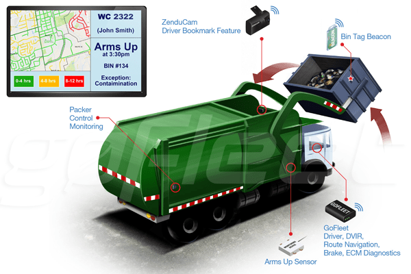
Our Waste Management Solutions offer several components that when combined, provide the biggest benefits. The heart of our waste management solutions is our GO7 device, the most popular telematics device in the world. It fits in the palm of your hand and easily connects to most vehicles, allowing it to collect GPS data plus information from the engine and other onboard sensors. This data is all relayed back to fleet managers through a variety of methods and with the latest encryption technology.
Another key piece of technology is a packer control monitoring sensor. This device automatically tracks how full a vehicle’s storage is, allowing a fleet manager to adjust plans as necessary. Next comes ZenduCam, with a driver bookmark feature that provides a view into the receptacle of the truck. Finally, complete waste management systems incorporate “arms up” sensors to record whenever a load is lifted and bin tag beacons to keep track of each deployed bin.
Data For Managers and Customers
These devices allow fleet managers to scrutinize the time spent in each step of the process. This includes visibility into how long each stop takes. Fleet managers may notice that certain stops take a long time to complete and they may need to take steps to improve accessibility to trash receptacles at those sites. Power take off diagnostics allow fleet managers to see the frequency and duration of each waste bin lift. Data can also be provided back to customers. Most notably, our comprehensive waste management solutions allow fleet managers to provide verifiable proof of service to their customers. The packer control monitor also provides some visibility into how much waste is coming from a particular route or location.
Limitless Additional Features
If you choose our waste management solutions, you also have the option to add numerous additional features. For example, we can pair your system with fuel card integration that tracks how much fuel is going into the vehicle. Fuel transactions can be compared with other data such as route planning and idle times to minimize fuel costs. We have a comprehensive route dispatching system that is delivered via one of the latest Garmin GPS systems. These can provide turn-by-turn assistance, hours of service tracking, and personalized messages to drivers. Our systems can also monitor and improve driver safety with long-term driver reports that can be used to reward good drivers and redirect those that need improvement. Our GO7 device provides immediate, in-vehicle feedback to drivers. For example, drivers can be given an audible warning for speeding, revving the engine, swerving, cornering, harsh braking, and much more.
These days most people are constantly followed by GPS wherever they go, whether the tracker is in a phone or installed in a vehicle. This, of course, creates some privacy concerns, but if used correctly the GPS data can also create amazing maps.
Volkswagen and Mobileye Combine Efforts
Some of these efforts are aimed at making money. For example, vehicle manufacturer Volkswagen announced a partnership earlier this year with Mobileye, a company that develops technology for computer vision, machine learning, data analysis, localization, and mapping. Mobileye’s main product is a mapping service called Road Experience Management, and it will be installed in all new Volkswagen vehicles starting in 2018. The devices will collect real-time data on road conditions that is aimed at giving autonomous vehicles more information to help them better navigate the road.
The Road Experience Management devices have front-facing cameras that collect information on things like lane markings and sign placement, and that data is then used to update maps. Eventually, Mobileye hopes that virtually all vehicles on the road will be collecting this type of data and that will create incredibly accurate maps built on passive uploads from everyday drivers. Autonomous cars rely on redundancy created by maps. They have sensors looking forward to ensure a clear path but they are also simultaneously reviewing map data to make sure the path forward is expected to be clear. If a map is outdated, perhaps by not showing a road closure, then the sensors on the car become the only thing telling the car that it needs to stop and the redundancy is gone. Crowdsourced data can improve both the underlying maps for autonomous car purposes and also provide a stream of road condition information, like updates on traffic congestion, that can be used for drivers today.
Nonprofit Crowdsourced Maps
Crowdsourced maps are not all about making money, though. OpenStreetMap is a nonprofit organization made up of a community of mappers who built an open source map that allows people from around the world to add information about roads, trails, cafes, railway stations and more. Anyone is free to use the map for any purpose so long as it is appropriately credited. Financial support to make it possible has come mostly from a number of universities and technology companies. Another example is Missing Maps, a nonprofit built on OpenStreetMap that uses crowdsourcing to map out roads and other features in vulnerable places in the developing world so that aid workers can respond better to crises.
Geotab Helps You Find Fuel
Hundreds of thousands of Geotab devices are on the road collecting GPS and other data every day. One particularly interesting piece of data that many Geotab users collect is fuel fill-up information. Geotab collects this anonymized data on about 60,000 fillups each day and can correlate that information with GPS coordinates. This data can help mapping services to locate fuel fill-up stations that have not already been incorporated into their maps. It can also help companies tinker with their fill-up policies to allow drivers to spend the shortest amount of time possible at the station.
The trucking industry appears to be slowly moving closer and closer to due date for trucker compliance with a new regulatory burden requiring them to use electronic logging devices (“ELDs”). Some companies may have thought they received a reprieve when new U.S. President Donald Trump issued a “regulatory freeze” memo. That memo contains an exemption for regulations related to “health” and “safety” issues, so there is some disagreement over how it should apply. There is also some additional uncertainty because Congress has also acted in recent weeks to rescind many regulations installed at the end of President Barack Obama’s term.
The Federal Motor Carrier Safety Administration now appears set to move forward with the December deadline. This ELD rule is all about the federal government moving beyond piles of handwritten records into more reliable, automatically-generated data. ELDs will ensure trucker compliance by generating computerized records. Many trucking companies are already using electronic logging devices, as the federal government has been accepting ELD certifications since early 2016. If you want to learn more, download our whitepaper entitled Understanding the FMCSA’s Final Rule on ELDs. The paper explains the ELD equipment requirements and time-frame for trucker compliance.
The 2019 ELD mandate need not be seen as just a regulatory cost by trucking companies. A high-quality ELD can capture a great deal of information and that can be used for multiple purposes. One example would be collecting data for International Fuel Tax Agreement (“IFTA”) compliance. IFTA is an agreement between most of the United States and the Canadian provinces to help address the tax disparity between the two countries. Basically, when a trucker fills up at the pump he or she is paying some fuel taxes. The trucker may fill up in a state or province with a very high tax, but then actually burn most of the fuel in a low-tax state. In order to clear up the disparity, the trucker files a report showing how much tax was paid and how many miles were traveled in each jurisdiction. The trucker will basically calculate how much tax should have been paid to each jurisdiction and then the trucker will either have to make an additional payment or receive a refund to pay the correct amount of tax.
Geotab Drive can easily ensure trucker compliance with IFTA by using GPS data to automatically track the truck’s route. That means that instead of logging odometer readings at every border crossing, a driver can simply drive on while the onboard sensors collect the miles logged in each state. This is simpler for the driver and his or her company, but perhaps more importantly, it is also more accurate. Automated systems are less likely to have errors and less likely to be audited by regulators. Our add-ons can also track fuel purchases and automatically populate tax forms to further ease trucker compliance. Our wide variety of solutions can go much further to help simplify maintenance records and more.
Keeping track of activity on a busy site can be a challenge for any manager, but GoBeacon asset tracking tags can be easily attached to pretty much any asset or worker to track locations and other relevant data. Together, a cluster of asset tags and data collection points can paint a picture for a manager of what is happening on the site.
Meet the GoBeacon Asset Tracking Tag
Each beacon is a small flat tag that is just over an inch long on each side (32 mm by 32 mm). It collects data from a variety of onboard sensors, including a GPS location tracker. It can also measure temperature, light exposure, and impact. The GoBeacons have a battery of two years and broadcasts their signal via Bluetooth over a radius of about 650 feet (200 m). That signal can be collected via a GoFleet Asset Tracker, a Bluetooth WiFi Hub, or any common Mobile Device. The information is then collected into the cloud where it can be easily accessed through the GoFleet software system from a computer or mobile device.
Attach The Small, Rugged Beacons Anywhere
The beacons can be attached to almost anything you need to keep track of. Common examples are trucks, trailers, and other vehicles. This can allow fleet managers to know exactly where the vehicle is and be alerted if it leaves its work area. Major pieces of equipment or expensive tools can also be tracked by the GoBeacons. Perhaps the greatest value of the beacons, however, is for field worker management where they can be use for employee location tracking. The small beacons can easily clip onto a shirt, clipboard, cell phone, keychain, or any other number of places that allow a worker to easily carry the beacon without constraining his or her work.
GoBeacons Have a Variety of Uses
GoBeacons can help with field worker management by monitoring personnel on a construction site or similar location. The beacons are weatherproof and they can easily provide notifications when a worker enters and exits the site. That data can be used to track work time and the beacons can also help rapidly locate a particular employee if needed. We also offer various integrations to help optimize scheduling and communications related to deliveries to the job site, and a man down system that can ensure managers become aware of injuries on the work site.
The beacons are also an inventory-management tool that can drastically reduce losses due to theft or simply misplacement of tools by field workers. Managers can set a geofence around a worksite and then set up alerts so that they are notified if a tool leaves the site unexpectedly. The beacons can also measure proximity to a smartphone and give off light or sound signals, and that allows field workers to find a missing tool if it has been tagged. This can result in huge time savings.
Employers have a very important role — and responsibility — to help reduce the number of injuries and deaths related to vehicle collisions. Putting a stop to speeding requires action. Employers can positively influence driver safety both on and off the job through safety-focused leadership.
Speeding is not a more efficient way to get from point A to point B, in fact, it has been mathematically proven. For example, on a trip in the city, any time saved can be easily added back if you run into traffic or get a string of red lights. Therefore, allowing your drivers to speed is a false economy — any time saved is marginal as compared to the indirect accident costs and increased risks. Additionally, speeding is illegal and the related fines are highly expensive for companies. For everyone’s safety, there is no need to speed. Getting to your destination safely, without breaking the law or being involved in a crash is the best goal.
Companies need to take a stand on whether or not speeding is worth the increased risk of crash and the related potential for legal cost and bodily injury. Launching a company safe driving campaign for employees is highly recommended by the Network of Employers for Traffic Safety (NETS) and others.
The Opportunity for Employers: Reduce Speed and Save
Employers can significantly save (on fuel, other related costs, and most importantly save lives) by introducing an initiative to reduce speeding in their company. A speed reduction campaign can support a company’s overall fleet safety program and enhances driver protection and productivity. Additionally, the U.S. Department of Labor reports that a safe driving program can “protect your organization’s human and financial resources” and ward off “potential company and personal liabilities.”
With many companies, fleet costs take up a large portion of the total operating budget. A safe driving campaign presents a new avenue for cost savings, and is a win-win for everyone.
Three Reasons to Launch a Driver Safety Program for Speeders
Reason 1: Fuel and Emission Savings
These fast fuel facts below make a convincing argument for a no speeding campaign:
Reducing speed can add up to significant cost savings for employers — money which could be redirected to more important areas.
Using 118 gallons of fuel per year at an additional cost of $.70 per gallon = $100 extra per vehicle per year, plus wear/tear and risk. $100 over 500 vehicles = $50,000 annual savings opportunity!
Total fleet average collision repair cost is $2,300 = $230,000 annual savings opportunity, just for physical damage (BusinessFleet.com/NETS).
If we use half ($8,250) of the industry average ($16,500) which includes liability, workers comp, etc., = $825,000 annual savings opportunity (NHTSA).
Reason 3: Reducing the Cost of Crashes
In the U.S., traffic crashes cost employers $47.4 billion in direct crash-related expenses including medical care, liability, productivity losses, and property damage (NETS).
Speeding alone resulted in $8.4 billion in crash-related expenses for employers. Distracted driving resulted in $8.2 billion (NHTSA).
Speeding is a top contributing factor to traffic crashes. In 2013, speeding was linked to 29% of all fatal crashes, and 9,613 lives were lost in speeding-related crashes (NHTSA).
Here’s how it can be done.
How to Launch a Successful Driver Safety Campaign
Set a goal.
Identify a campaign manager and find a sponsor.
Create a plan.
Promote your campaign.
Evaluate the impact.
In this case, the goal would be to reduce the upward trend of speed violations and vehicle accidents. Assemble a team of people who will champion the initiative. Be sure to include employees on the campaign committee. Plan activities and communications to promote the campaign. Posters with facts and visuals can be very effective. Communicate regularly throughout the campaign to keep interest and enthusiasm going.
Using Telematics Data to Manage Speeders
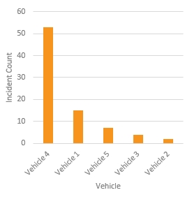
A telematics-based speeding report can tell fleet managers who has been speeding and how often. For example, the Top 5 Speeding Violations report displays the top 5 drivers or vehicles with the highest number of speeding events by day, week, or month. Whether the fleet manager has received complaints about speeding drivers or simply wants to improve overall fleet safety, this report helps identify which fleet drivers have the most dangerous driving habits.
Sample telematics based speeding report
Stop Speeding and Save Money
Speeding is one of the most prevalent factors contributing to traffic crashes. In addition, speeding increases fuel expense. Therefore, targeting driver speeding is a truly worthwhile effort for employers.
Implementing a “No Need to Speed!” initiative can save a company thousands of dollars (and that’s a conservative estimate). Protecting employees from motor vehicle crash injury can be a profitable investment of resources and time. Also, it helps companies underscore that they truly care about the well-being of their employees.
Your life can change in seconds — and someone wants you home tonight, so why wouldn’t you choose safety?
Original Article: https://www.geotab.com/blog/driver-safety-for-speeders/
Written By: Susan Miller, Senior Fleet Account Manager at Geotab