food transportation, cold chain custody, telematics, temperature monitoring

Food Transportation: Why Temperature Monitoring Should Not Be Overlooked

Given the current economic environment, many commercial transportation fleets can’t afford to have hiccups in their operations. When speaking about food transportation, this remains true as food products are at a higher risk of being rejected by receivers if they do not meet strict temperature requirements. As a result, more stress has been placed on enforcing food safety regulations and using the right telematics tools to reduce cargo losses of temperature-sensitive goods. 

Financial Implications of Temperature Sensitive Products 

Food transporters are at risk financially if they are unable to abide by strict temperature storage guidelines. In the past, when loads are found to not meet strict transporting guidelines, receivers may deem the products within the load unsafe and refuse to accept them. Meaning, if even one shipment in a 36-foot trailer gets transported at an improper temperature, businesses can lose up to $30,000

In an attempt to mitigate financial losses resulting from the improper transportation of temperature-sensitive goods, telematics technology is steadily gaining popularity.


Why Shipments Get Rejected

Regardless of how far a delivery is, transporters with subpar temperature monitoring systems may not meet specific temperature qualifications. When this happens, receivers may decide to reject the shipment, as previously mentioned. For example, if frozen goods are on the brink of thawing when they arrive, or if heat-sensitive dairy products are delivered warm, receivers could refuse to accept the load. Consumers are at risk of bacterial poisoning if these products are allowed to reach the store shelves.


Regulations to Ensure Safe Food Transportation 

To reduce the likelihood of spoiled products being sold to the public, in 2017, the FDA introduced the Food Safety Modernization Act (FSMA). The focus of the FSMA was to create a strict, standardized playbook. The regulations would prevent improperly documented and unsafe transportation of human and animal food products regardless of whether the products were in open or closed containers. 


According to the FSMA, individuals in food transportation must ensure the following: 

FSMA Deadling Approaching

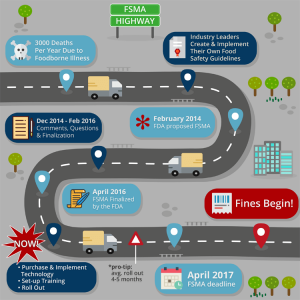
  1. Vehicle trailers transporting food products must be pre-cooled to specific temperatures by shippers prior to the goods being loaded;
  2.  Cold-chain integrity must be maintained during the entire trip, and transporters must explain any temperature breaches along the way;
  3. For at least one year, shippers and transporters must record the last three shipments of trailers for each delivery.

With these rules in mind, it’s important to note that the FSMA did not mandate the use of telematics. However, it is easy to understand why telematics would make meeting compliance easier and more precise.


Initial Compliance Concerns 

When the Food Safety Modernization Act was introduced, many found that their fleets were at risk for not meeting requirements. This is because their drivers were relying on outdated and inaccurate temperature monitoring tools. Such systems typically only provided drivers with basic information about trailer temperatures as they did not use advanced telematics technology to see what the actual ambient air temperatures are. Older systems would only show temperature readings on in-cab displays of the blower output air temperature. These readings can be misleading as the device does not take into consideration the conveyor effect of cold and warm air variations caused by opened and closed doors. 

Temperature monitoring by samsara


What Consultants Recommend For Food Transportation Businesses 

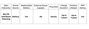
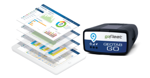
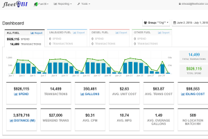
With strict regulations in place, many businesses are finding that older processes related to reporting and temperature monitoring are no longer sufficient. Meaning more loads are at risk for being rejected and more businesses are at risk for not being able to provide proper cold chain custody reports. When speaking to industry consultants like GoFleet, food transporters are offered a 360 telematics solution that focuses on temperature monitoring, GPS location tracking, and digital reporting to ensure FSMA compliance. 


Temperature Monitoring and Maintaining Appropriate Trip Temperatures

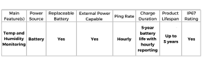
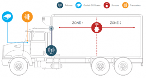
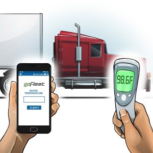
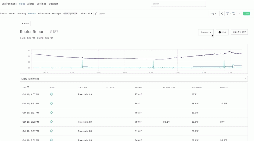
Telematics temperature monitoring solutions are suggested for food transporters because smart systems can be utilized to monitor the indoor environments of trailers. They ensure that the temperature is correct and meets compliance. This is possible as solutions can be placed strategically throughout the trailer to continuously report on the temperature when the vehicle is in motion and even whether specific pre-cooling temperatures have successfully been met prior to loading. 

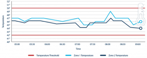
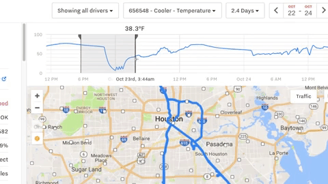
When discussing the capability of monitoring the ambient temperature of the trailer throughout the entire trip, solutions can notify when temperatures begin to change to unsafe levels. This is critical because the temperature can drastically change in just a short period.  When a trailer is loaded after pre-cooling requirements are met, the ambient temperature in a reefer can drop by 10 degrees within 5 minutes, depending on the outdoor weather conditions. 

Even after a drop in temperature after loading, some trailers could have a chance at re-cooling if the blower is able to distribute cold air without interruptions continuously. However, if there are frequent stops which require the trailer doors to open and close (introducing warm air), re-cooling the trailer to a safe temperature may never be possible. In cases like this, telematics systems could notify drivers that they will need to set aside time for the trailer to cool back down to the appropriate temperature before continuing their route. Forgoing this cooling break puts fleets at risk for not complying with FSMA requirements. 

When temperature monitoring technology is associated with a GPS tracking solution, teams can even collect temperature data and relate it to unique location points. Meaning, teams can see possible temperature changes with the distance traveled and stops made. This helps in predicting when cool-down stops may be necessary.


Digital Reporting to Keep Cold Chain Custody Reports For Investigations 

Digital reporting solutions are crucial to food transporters because of the reliability, accuracy, and easy storage benefits that comes with it. Specifically, telematics reporting solutions stop drivers from having to manually record temperature data. Instead, the solution does it automatically and even associates specific GPS locations to the report. Human error is reduced, and the necessary paperwork is always completed. In fact, when a GPS location is associated with a change in temperature, it can allow the fleet to confirm how much of the shipment was affected and whether any cargo can still be delivered. 

When discussing cold chain custody reports, digital reporting solutions automatically complete and keep temperature reports in a digital format. Meaning, if there is an investigation about a previous delivery, a fleet manager can easily pull the appropriate reports required from the cloud where they are stored. In fact, solutions like this can help reduce warehouse costs as physical storage locations will no longer be necessary as every report can be stored digitally on the cloud for infinite periods. 

Reefer temperature report


Food transporters can’t afford to overlook temperature monitoring any longer. If you’re interested to learn more about how you can ensure that your team is always remaining compliant when moving loads, contact our Compliance Specialists

Revisions To FMCSA Federal Hours Of Service Rules

In the recent weeks the trucking industry has been praised for being a key component to the economy. As it employs over seven million people and moves approximately 70% of the nation’s domestic freight, many have found that during an unprecedented time, it was truly an essential industry. With this being said, to help allow the commercial transportation to keep moving some modifications to regulations and rules have been made. 


Hours Of Service Modifications 

On May 14, 2020, the FMCSA announced that there would be upcoming changes to the Federal Hours of Service Rules for commercial driving. Such updates are expected to modernize the HOS regulations and provide the U.S. economy as well as American consumers an estimated $274 million in annualized savings. The revisions were previously discussed and reviewed by the FMCSA in August of 2019. Below are the four main revisions. 

  • Adjustments for the 30-minute break rule so safety and flexibility can improve
    • After 8 hours of consecutive driving, a driver is able to use their required break as being on-duty but not driving rather than being off-duty
  • Drivers will be able to split their required 10 hours off-duty into two periods (either an 8/2 split or 7/3 split) with a sleeper-berth exception 
    • Neither split will count against the driver’s 14 hour driving window 
  • The maximum window of when driving is permitted will be modified to extend by two hours
  • For certain commercial drivers, the short-haul exception will change by lengthening the drivers’ maximum on-duty period to 14 hours (from 12 hours) and extend the distance limit to 150 air miles (from 100 air miles)


It is important to note that the removal of a key point of the 30 minute to 3 hour pause to the work day from The Notice of Proposed Rulemaking (NPRM) is not part of the Final Rule.

These modifications will go into effect on September 29, 2020. 

For more information about these modifications and other news or regulations pertaining to the commercial transportation industry, visit: FMCSA’s Website


How The Commercial Transportation Industry Will Be Affected 

Since there is more focus to ensure that drivers are having adequate sleep and rest while they are on the road to reduce fatigue related road incidents, fleet managers can’t risk falling behind on ever-changing rules. When discussing these new changes, it’s important for commercial drivers to understand how their fleet technology may be impacted. 


Rulesets For Electronic Logging Devices 

For those using Geotab Drive ELD’s, Geotab has noted their commitment to following ANPRM and NPRM processes with Partners and associations. Meaning they are making relevant changes to the device rulesets in time for it to be used by the official effective date (September 29, 2020). As a long time partner of Geotab, we can ensure that our customers who use these devices have nothing to worry about and should keep their eyes open for further communication about device ruleset updates! 


Interested to learn more about how your fleet can better abide to strict regulations, save hundreds of dollars or even improve the driving conditions of your team? Contact us today! Regardless of your needs, we have consultants who specializes in every aspect of your fleet who can help! 

car crash

R2V Communication Increasing Vehicle Safety While Decreasing Accident Costs

Fleets around the world are researching how they can improve their operations. Recently, responder-to-vehicle (R2V) communication technology has been seen as a tool that can improve safety and visibility. In fact, many government fleets are looking at how R2V communication and telematics data can decrease accident costs by reducing the chance of civilian and first responder vehicle accidents by upwards of 90%


Using Telematics And R2V Communication To Boost Safety 

Responder-to-vehicle communication, or otherwise known as R2V communication, is a new technology that allows for first responder vehicles to communicate with other vehicles on the road. Emergency responders and other roadway fleets leverage this technology to drastically reduce collisions between civilian vehicles and first responders. Approximately 31,600 accidents involving fire vehicles and approximately 6,500 accidents involving ambulances were reported in the United States yearly between 2000-2009. Government fleets believe that brighter lights and louder sirens are no longer as effective as they once thought. Rather, new advancing technologies are proving themselves to be extremely useful. Specifically for warning civilian vehicles of the location of emergency responders to reduce collisions by boosting driver alertness and rerouting traffic. 


HAAS Alert Leveraging R2V Communication 

To successfully deploy digital alerting efforts, HAAS Alert leverages cellular-based data within their digital alerting service Safety Cloud®. By knowing when emergency vehicle lights are ‘on’ or ‘off’, as well as the real-time location of vehicles, Safety Cloud is able to send notifications to users within a specific geographic area or proximity. So, when a first responder vehicle or amber fleet vehicle is moving with their lights ‘on’ or are on scene with their lights ‘on’, the service will automatically relay that information it to nearby approaching drivers. HAAS Alert automatically hides emergency vehicle locations if their lights are ‘off’ while they are stationed at vehicle headquarters (such as a fire hall, police station or hospital) or are conducting system checks by toggling their visibility and setting them as blacklisted. When this information is recorded and known, the data can be provided to the public to increase overall safety and response times. 

haas_alert_dashboard

Digital Alerting With Telematics Data 

As mentioned previously, when telematics data about emergency vehicles and roadway fleets is collected, it can then be distributed to the public via smartphone apps or car dashboards. Waze for example is a GPS routing application that HAAS Alert has partnered with to help provide this information to the public to help increase safety and reduce collisions. By integrating with Waze, HAAS Alert can send alerts and notifications from their Safety Cloud to users of the app when they are in the geofence zone of a first responding vehicle or if they are travelling on the same route of an emergency vehicle. Meaning, not only can drivers redirect attention to the road to reduce the chance of a collision immediately, but civilian drivers can also be directed to take alternative routes. When this telematics data is public and is provided to drivers, civilians are more aware of the presence of emergency vehicles and are even directed to take alternative routes. Resulting in not only fewer resources being used by first responders (for example idling in traffic), but for faster arrivals and for fewer roadside accidents to occur. 


The ROI Of R2V Technology 

It may be clear on how R2V communication technology is beneficial for keeping drivers safe, but it’s important to also highlight the financial benefits that arise when using R2V technology like HAAS Alert’s Safety Cloud. When using technology like Safety Cloud, government fleets can expect to see not only fewer costs associated with driving incidents but improved tracking of their efforts. Firstly, with more attention directed to the real-time movement of first responding vehicles, civilian drivers are less likely to be involved in an accident with them. Meaning, there is almost an instant ROI as stopping even one accident from happening can save thousands of dollars in insurance fees, medical bills, and vehicle repairs. HAAS Alert also provides advanced reporting features through internal dashboards. So not only do fleet managers visually see all of their vehicles (whether they are responding to a scene or are stationed and waiting), but they can pull up historical reports to review arrival times, drivers alerted, time spent on-scene and more. 

When fleets need to move quickly and safely, innovative technology that focuses on connectivity and data sharing can’t be overlooked. If you’re interested in learning more about R2V communication technology and Safety Clouds that government fleets are using to their advantage, contact us today. Our consultants can provide you with detailed information about your industry and how telematics tools can help boost safety and even improve costs across the board. 


Cellular Asset Trackers: Don’t Make The Mistake Of Investing In The Wrong One

There are so many cellular asset trackers in today’s markets for fleet managers, that things can sometimes seem overwhelming. How do you know which hardware you need to buy or how you can get the best value out of it? We will be discussing the different hardware devices for various fleet management needs and the scenarios in which fleets can use each device.


Cellular Asset Trackers? Why Not Satellite Asset Trackers or BLE Beacons?  

When speaking about asset trackers, there are many options available. However, the way they differ from each other initially is based on how the device transmits information. 

  • Cellular asset trackers use cellular network coverage to transmit data and information about an asset. As coverage varies based on specific locations, assets using these trackers that enter no coverage zones will not be able to transmit data.
  • Satellite asset trackers use satellite connectivity to transmit data about an asset and can be the more reliable option if your asset is travelling out of cellular coverage.
  • BLE beacons have pre-requirements (like asset trackers or BLE readers) in order to transmit data and information about an asset or group of assets.


Below we discuss 6 cellular asset trackers that are available, and how their features differ.


6 Top Performing Cellular Asset Trackers 

Flex Solar Asset Tracker 

The Flex Solar Asset Tracker is an asset tracker that syncs with MyGeotab and works similar to a Geotab device as it allows the tracker to be visible on a map. The tracker is solar-powered and is utilized primarily for the general tracking of bulk cargo containers, vehicles and other large assets that may not have a direct power supply – thus requiring solar energy. The ability to power the device through environmental conditions is critical as certain large assets that are travelling far distances or are being stored outside for long periods of time (like shipping containers) are often standalone assets with no power connections. It should be noted that a full charge can allow the Flex tracker to last up to 4 months with multiple pings per day. It’s also important to note that this tracker can be expandable for door sensing, temperature probing and tire pressure tracking.

Use-Case: How Long-Haul Transporters Are Using Flex Solar

The Flex Solar Asset Tracker is praised for its ability to remain powered with solar energy. Meaning, businesses no longer have to worry about removing trackers to replace batteries. Instead, they only rely on the sun to power the device so data about the asset tracker can be transmitted. This is particularly useful for commercial transportation fleets who conduct long-haul deliveries. As the device can continue to charge and transmit information via the sun, the asset tracker can always send real-time data. Typically, this solar power feature is praised by those who enjoy a ‘set-it and forget-it’ device, or for those who are looking to take advantage of renewable and free sources of energy.


Blackberry Radar

The Blackberry Radar device focuses on asset tracking for cargo, more specifically, for vehicles and non-motorized assets like bulk containers, trailers and various equipment where content quantity needs to be monitored. The tracker is unique as it requires a specific installation to allow for its radar feature (which analyzes the quantity of cargo within a container or trailer) to be used. Once the device has been placed at the predefined orientation, it can analyze the content capacity of the asset it is attached to. This is explained as acting like a camera that measures how much cargo is present. Having a radar function like this is new and allows for users to complete better planning as there are more accurate (and visual) load-stats available.

Use-Case: How Delivery Vehicles Are Using Blackberry Radar 

As previously mentioned, the Blackberry Radar tracker allows for radar sensing and load analysis of the quantity of content within an asset. Meaning, users can see exactly how much is within a trailer, truck or container in real-time. This radar tracker is particularly useful in delivery fleets who constantly receive new delivery requests. Using this tracker allows dispatchers to analyze and review the content quantity of each delivery vehicle. Essentially judging which vehicles are full and whether near-empty vehicles have enough space to pick up additional deliveries to complete that day.


Remora2

The Remora2 tracker is utilized for general asset monitoring and has expandability opportunities with BLE beacons. As the tracker uses a Bluetooth 5.0 gateway, which allows it to communicate with other local asset tags to report on them, it is the ideal investment if you will later need to invest in various BLE beacons. As a standalone device, this tracker is similar to the Flex tracker that was mentioned previously as it allows for general location tracking. However, what differentiates itself from the Flex Solar tracker is that it has an ion battery. Meaning, depending on where an asset will be stored or used most of the time, having a battery option may be the more powerful and reliable choice. As well, when compared to the Solar Flex, it’s important to mention that it is the cheaper option as there is no solar-power technology required. It is also important to note that the Remora2 device has an anti-theft mode, tamper detection, is geo-fence aware, and functions as a 3rd party device on MyGeotab.

Use-Case: How Commercial Transportation Fleets Are Using Remora2

Similar to the Solar Flex tracker, the Remora2 tracker is typically used within fleets who are conducting long-haul deliveries that require more pings daily or are spending some time in a location where solar changing is difficult. Meaning, having an ion battery rather than a solar-powered battery would be the more reliable option to suffice reporting needs. 


Falcon 

The Falcon device is a temperature-sensitive tracker which allows for fleets to monitor temperature and humidity. The device embodies a 5-year battery life with hourly reporting so users have continuous monitoring of temperature-sensitive cargo. Similar to the Remora2 device, the Falcon device has an anti-theft mode, tamper detection, is geo-fence aware, and functions as a 3rd party device on MyGeotab. 

Use-Case: How Food Transporters Are Using Falcon 

When tracking goods that are sensitive to temperature and humidity, the Falcon is the go-to tracker for many fleets. Since the device focuses on allowing users to monitor the environmental conditions of containers, trailers, trucks and more, it’s the perfect tool to use when moving food products. As improper storage is not an option for food products as it can lead to spoilage, the Falcon tracker can monitor the temperature and humidity of the location where food products are stored to ensure that conditions meet strict regulations. Forgoing a device like the Falcon leaves food transporters at risk for being found incompliant as there are numerous rules  regarding the proper storage and handling of frozen food, fresh produce and meat products to keep consumers safe. 

advantages-temperature-monitoring


Sensoneo Bin Fill Level Sensors

Sensoneo Bin Fill Level Sensors are a smart, enterprise-grade waste management solution that focuses on monitoring waste content quantity. The sensor is a robust device that can withstand harsh conditions such as water and is shock resistant which is perfect for its use in waste management. Sensoneo focuses on allowing fleets to remain efficient and optimized as it monitors how full a waste bin is, alerting users when the bin is approaching capacity. Additional features of the device include; Bluetooth, pick-up recognition, temperature measurements, fire alarms, and overturn alarm options. 

Use-Case: How Waste Disposal Fleets Are using Sensoneo 

Sensoneo is leveraged by waste disposal fleets who empty waste bins. Typically, the device is attached to a specific bin to monitor how full the container is getting overtime, alerting users of when it is near-full and needs to be emptied. When the tracker sends an alert about the quantity level, fleets can create a route that only visits the bins that are full or are at least 80% full – passing bins that are less. Doing this helps to ensure that time is not wasted visiting bins that do not need to be emptied so work is optimized and resources can be saved. 


A Cellular Asset Tracker Cheat-Sheet

When it comes to cellular asset trackers, there are numerous devices available that any business can use and sometimes, their features can become confusing. To help businesses better understand what their cellular tracker options are, we created a feature comparison chart below based on our analysis above.

Still unsure about what cellular tracking device may work best for you, or would like to learn more about a specific tracker? Contact us today so we can set up a time to chat about your unique needs. 

COVID-19 Recovery: Why Your Vehicle Data Is More Essential Now

The past few months have been an unsettling time for many workplaces as the COVID-19 pandemic has drastically affected businesses. Since this global pandemic started, Geotab recorded and reported on datasets to help fleets better understand the current landscape. As we are on the road to recovery, it is important for businesses to review how the commercial transportation sector is performing in relation to their own performance. Reviewing industry trends alongside personal vehicle data can allow fleets to make actionable decisions moving forward. 

Below we use Geotab specific data that was updated on May 29, 2020, to help our readers better understand current commercial transportation activity, industry-specific activity, and fuel fill-up activity in relation to their operations. 


Commercial Transportation Activity: A Slow Increase 

With a baseline of February 2020 being used, it is clear to see in the image below that in comparison to the lowest dips in April 2020 (when many cities were in peak-response to COVID-19), there is a slow increase happening across the world. This is seen specifically in Canada, the United States, the United Kingdom and Australia. While there appears to be a rise and dip effect occurring, many view it to be a good sign that the dip does not last for long, as well that the rises are gradually increasing. 

Source: Geotab 

When speaking about the future, many believe that when businesses begin to reopen, their activity will drastically affect this graph. It is predicted that with more businesses reopening and requiring more inventory, stock or supplies, more vehicle use will occur. 


Industry Vehicle Activity: What Is Happening During The COVID-19 Recovery


While the above graph may show positive signs that vehicle traffic is increasing, it’s important to note that it is not the case for all industries. Since February 2020, there are a number of industries where vehicle activity has not recovered as much as others in North America. These industries include non-freight transportation, healthcare services and business services. Many account this lack of recovery to be due to many unique businesses not reopening, or being unable to reopen to full-productivity. An example where this is visible is in the public transportation sector which has seen a continual decrease in activity as public transportation use is low (possibility as a result of the public not commuting to work as they are working from home). 

Source: Geotab 

Some industries to highlight that are steadily increasing are construction, government, freight transportation, retail and telecommunications. This slow increase is typically due to the reopening of many businesses that could no longer hold off operations and were approved by governments to slowly reopen. For example, within the construction industry, the longer work was paused, the longer the delays for construction to be completed. When speaking about condo developments or other development projects, many companies could not financially afford to hold off construction due to financial and contractual responsibilities to home buyers. 


Fuel Fill-Up Activity: What Increases Can Mean 

In North American the vehicle telematics data gathered by Geotab confirms that fuel fill-ups of varying larger-sized vehicles are increasing. The data shows that since the end of April, there has been a noticeable increase in the usage of LDT (light duty trucks) and MDT (medium duty trucks) vehicles. This is likely in accordance with traffic increases for industries who are looking to resume operations. It is important to note however, that there are some vehicles such as MPV (multi purpose vehicle), passenger and bus that may not see such increases in fuel fill-ups until there are less restrictions on public contact and public outings. The steady increase in varying industries is important to monitor because it allows for vehicle-based businesses to see how their specific industry is performing overall. 

Source: Geotab 


What Your Vehicle Data Means 

Properly Collecting Data 

With all of this information available, it’s important for businesses to use it to their advantage. Specifically, by reviewing the vehicle telematics data of their own business in accordance with industry competitors. By using telematics solutions businesses are able to review current operations and see whether their organization is on par with industry trends.


Collecting Your Own Data 

In order for businesses to truly see results from the data gathered by Geotab, there must be processes in place to collect information related to their fleet. If no solutions are currently in place, or businesses are unsure about what should be used, the first step is to use a GPS tracking device like the GO9. For the purpose of this discussion, the GO9 can be used to record the GPS location of vehicles and depict usage within detailed reports. As well, it allows for easy add-on hardware through an IOX expansion port to allow for future tracking of HOS ELD, auxiliary, temperature monitoring as well as other third party monitoring solutions.


An additional tool to use to properly measure against the industry trends mentioned above, is to implement a fuel card integration. Using a tool like FuelBi allows fleets to better track the fuel fill-ups of company vehicles. While the device initially focuses on tracking and visualizing important fuel KPI’s and transactions, it is also used to monitor how frequently company vehicles are being filled. This directly shows the usage of company vehicles.


Comparing Company Data To Industry Data

When businesses reach the point that they have accumulated enough data to properly view how their fleet is performing, it can then be compared to the industry trends above. After reviewing the data in accordance to current industry trends, business owners and managers are encouraged to adjust their operations accordingly. What this means is that if businesses see that they are performing at a lower rate than their industry, they need to research why. Sometimes a lack of operational customers or possibly a decrease in availability of your team are the answers. As there are various reasons for why your business may not be recovering from the COVID-19 pandemic at the same rate as competitors, it’s important to work with professionals who can point out why this may be happening and offer solutions that drive results. 

Interested in working with a team who can help? Contact GoFleet today. Our team is experienced in data analyzation and consultation as our goal is to have every customer outperform their competitors. 

Telematics Is The Key To Successfully Set Up For Home Deliveries

Times are changing, and many businesses are learning that they have to adapt in order to stay profitable. With social distancing and business closure regulations relating to the COVID-19 pandemic beginning to lift slightly for some sectors, many business owners are finding that they need to remain creative to begin operations again. With the need to limit physical interaction still required, many businesses are turning to telematics to set up for home deliveries. 


Why The Spotlight Is On Home Deliveries 


As previously mentioned, many businesses are turning to incorporate home deliveries into their operations. This is largely due to the inability to operate as usual because the coronavirus pandemic has required the public to partake in social distancing to reduce the spread. As a result, businesses were provided two options. Either they could momentarily close their doors until the government feels as though it’s safe for them to operate as usual, or they could implement new home delivery and/or curbside pickup options to remain profitable. With the pandemic continuing, many are finding that keeping their doors shut is not an option so they must adjust their operations – specifically to offer home deliveries.


Below we discuss not only the tools that can allow businesses to succeed while implementing home deliveries, but the ways that businesses are getting creative with this. 


Home Deliveries – Who Can Do It? 


Home delivery services may seem daunting to those who are not used to offering it, but it should not be feared. Currently, there are numerous businesses who are embracing home deliveries and are finding new ways to cater to their customers who are choosing to stay home and keep outings limited.


Brick And Mortar Or Specialty Stores


Depending on how the business was run previous to COVID-19, many brick and mortar businesses may already offer some form of delivery. However, those who did not have this offering before are quickly learning that incorporating an inventory and e-commerce platform is essential to continuing operations when consumers are choosing to stay home or limit shopping outings. By remotely working with tech-businesses to adjust websites, product images and inventory, brick and mortar as well as specialty store owners are finding that home delivery is possible once they find a reliable way to transport products. 


Food And Beverage Businesses


As one may assume, the food and beverage industry has been struggling to find their way after restaurants and cafes were ordered to close. However, with applications like UberEats, many restaurant owners are still able to provide food and drinks (even alcoholic beverages) to the public! In fact, this need for delivery has even inspired restaurants that can’t afford the fees of food delivery apps to employ delivery personnel to deliver orders that are taken over the phone or online. 


Consignment Stores 


Consignment stores are also finding new ways to run their businesses during this time. Specifically, by creating websites and incorporating e-commerce platforms to allow for owners to upload images of consignment clothing to allow customers to not only purchase online, but have it delivered to their home without contact. This idea being similar to many big-name clothing stores who have offered online shopping and home delivery for years. 


How To Use Telematics To Set Up For Home Deliveries 


There are many good ideas listed above in how unique businesses are finding ways to cope with running a contactless business during the COVID-19 pandemic. But apart from implementing e-commerce platforms, how can delivery services be run and properly managed? The answer is this: telematics solutions. Below we discuss how business owners can successfully use telematics to set up for home deliveries.


Completing Deliveries With Dispatching Solutions 


When it comes to using telematics to set up for home deliveries, if businesses are unable to use a mailing service, they will need to dispatch drivers to make deliveries. In cases that require an overwhelming number of orders or orders that span across a large geographical area, it’s critical that businesses use a dispatching solution. Using a dispatching solution can help business owners better manage their team in terms of who is completing which deliveries and what their routes will be so operations are optimized. 


Dispatching solutions like ZenduWork are great for businesses who are required to have more than one driver delivering orders as it organizes exactly where the driver is going, where they are in real-time, as well as order updates. Meaning, you’ll always know how your deliveries are going so you can even notify your customers about their order. 


Mapping Tools And GPS Tracking Solutions For Deliveries 


Another solution that is useful when businesses are using telematics to set up for home deliveries, is the use of mapping tools, specifically gps tracking. These types of solutions allow for business owners to stay up to date with what stage a delivery is at, allowing for up to date information about expected arrival times to be relayed to customers – boosting customer satisfaction. For businesses who offer same day delivery or focus on immediate delivery, this is critical as you are able to share this information with customers.

NEW Tracking GIF


Live Map Views For Customers 


Another solution that is extremely useful, especially for businesses who offer immediate delivery, is the use of mapping solutions like Public Map Share. This solution focuses on providing customers with the option to view in real-time where their order is. This is possible by using GPS tracking assets on vehicles conducting the delivery and relaying that information visually on a map that is updated every few seconds. Showing the delivery moving along its route. In turn, the customer can be provided with their own link for this map so they can view in real-time where their delivery is and whether it’s time to retrieve it from their doorstep. 


As business owners can see, implementing delivery offerings into operations may not be as daunting as it once seemed. For many, it just took a little creative thinking in addition to the right telematics solutions to properly and accurately conduct the deliveries. If your business is looking to improve their delivery offerings, or would like to better understand how using telematics to set up for home deliveries can help you begin delivery services, contact GoFleet today. We’re confident that we have a solution that can fit your unique needs during this uncertain time.

Managing A Fleet During A Crisis: Where To Start

As the world changes, businesses must react quickly in order to remain profitable. While this may be assumed, many still question how this should be done, especially within the commercial transportation sector. Below we discuss how in times of crisis, business owners must take extra precautions when managing a fleet during a crisis as regulations, demands and technologies are all changing. 


What To Do When Managing A Fleet During A Crisis


1. Follow The News As Regulations May Change


During times of crisis or uncertainty, it is not uncommon for officials to adjust regulations and rules that businesses follow. Typically this is to help organizations stay afloat if they are struggling or sometimes this is done to help better support the public. When speaking about current events, this tip of following the news for changing regulations and route information is extremely relevant for fleet managers who want to properly manage their team. 


During the recent and ongoing COVID-19 crisis, new regulations relating to HOS limits were announced as a way to help provide communities with more supplies. Specifically allowing drivers to operate commercial transportation vehicles even if they are over the previous hours of service limits. If fleet managers were unaware of this change, they would be unable to either cater to changing demands from customers regarding frequency of delivery (as depleted supplies will force businesses to place more strenuous orders), or provide adequate time off for drivers between routes. Both are troublesome for the well being of fleets.  


2. Follow Up-To-Date Information About Routes


On the topic of news about routes, information regarding a new 511 website and on-route screening was made available. The new 511 website was made available by officials so drivers could have better information about rest-stops, while information regarding possible on-route screen protocols were made available so drivers could anticipate possible delays. Both being critical for drivers to know about as it can affect their deliveries.


Source: 511 Alerts


When discussing the 511 website, it’s important for managers to update their drivers about this information as having access to this website can allow drivers to better understand where they can stop during routes and what is available at each stop. Without this knowledge, drivers can be left confused about where they are expected to rest with new COVID-related closures, or which stop will fit their needs. This is critical knowledge to share to drivers from managers because when a stop does not have adequate parking or resources, drivers will need to drive a detour route to find somewhere to rest. 


When discussing news related to on-route screening protocol, it’s important that drivers understand how their routes may be impacted. Specifically, whether there could be additional waits related to health screening. This additional screening would be for the purpose of ensuring that drivers are healthy enough to complete deliveries by officials and even receivers. In addition to notifying drivers of possible screening protocols, fleet managers can help to alleviate possible wait times by implementing symptom monitoring apps like the GoFleet Health Check App. This screening app works by having drivers input not only their temperature, but whether they are showing any possible symptoms of illness. Ensuring that there is proper documentation of the health of a driver. 


While managing a fleet during a crisis like the coronavirus pandemic, managers must be aware of possible impacts to drivers. Not only does this include changing regulations, but changing news and updates about route information. 


3. Review Current Technology And Tools


Being aware of your industry as a whole is only part of the process while fine-tuning your management tactics during a crisis. Fleet managers must also review their current operations and the technology they are leveraging. Doing so is crucial to ensuring that their team is working seamlessly and efficiently with no (sometimes hidden) losses. In order to do this, managers are suggested to perform a complete audit of their organization – the audit would be on everything from the software or solutions that are used to the protocols that employees follow. Such audits would focus on reviewing employee tasks in relation to the effectiveness of the tools used. Doing this will help ensure that your business is running like a well oiled machine with minimal hidden issues. While conducting an audit, watch for the following;

  • Keep an eye out for whether a tool or solution only has one limiting purpose or function,
  • Whether tools or solutions are unable to sync or integrate with other systems, 
  • Or, if current solutions are pulling incomplete data. 


For example, a dispatching system that only allows for the dispatching of drivers may be limiting if you also find yourself using supplementary tools to optimize routes, communicate with drivers or even send forms. As there are new solutions available like ZenduWork, all of these features can in fact be combined into one solution for one price. While managing a fleet during a crisis, having everything available in one location can make tasks and reporting so much easier and even reduce the chance of human error. 


While this review is performed, it’s not uncommon for fleet managers to find that they are in fact overloading their organization with unwarranted solutions. Sometimes when looking at the effectiveness of a tool and the utilization of it, managers may find that they are overspending on multiple solutions when single tools can complete the tasks of many. Remember, cutting down on unnecessary solutions and moving forward with all-in-one solutions can help your bottom line not only when speaking about how much the business is spending, but how much the business is improving in regards to productivity and efficiency. 

4. Research What Tools Can Help While Managing A Fleet During A Crisis  


After you take a look at your current tools and solutions, it’s important for managers to take a moment to see how else they can improve their fleet. Specifically by researching what additional resources can help them during this time and what their competition is using. Sometimes, during this audit process, fleets discover that they have new issues that they must address immediately if they want to remain successful during uncertain times. Some common issues that may come up are the following:

  • Poor driver performance as there is an increase in fines, complaints, fuel use or vehicle wear and tear
  • Discrepancies in paperwork, data and reports as documents are missing or incomplete 
  • Lack of streamlining as processes do not flow together 
  • Incomplete training resulting in improper processes 
  • Lack of communication 


Understanding exactly where any issues are can help fleets see where they need to direct attention if they want to move their team forward. For example, when speaking to driver performance, fleet managers may be made aware of an issue as drivers are continuously receiving penalties, fines or complaints in addition to requiring more maintenance and fuel fill ups. Finding these issues and bringing them to a solutions provider can help fleets find the right product to solve it. In this case, proper driver training through solutions like ZenduLearn would be useful to implement. As the solution would focus on using driving data and unique training modules to improve driving behaviours, events like speeding, harsh braking, acceleration and idling can be expected to happen less frequently. In fact once implemented, fleets can see drastic changes in skill, and even lowered costs associated with poor driving behaviour. 


If you’re interested to learn more about what solutions may help when managing a fleet during a crisis, contact us today. When it comes to addressing the issues mentioned above, we have solutions that focus on boosting efficiency, productivity and success! 

Precision Farming: How Technology Can Improve Efforts

Even though many still envision farming to be very labor intensive, it’s important to highlight how this has changed. Specifically how the agriculture sector has been adopting innovative technologies that pair with heavy machinery to boost efficiencies. And as a result, allowed for time-specific operations to be met regardless of changing variables. Below we discuss how telematics and precision farming is the new normal for countless agribusinesses within the agricultural and agri-food chain.


Telematics And Precision Farming: What Is The Relationship  


As briefly mentioned, telematics continues to find new and impressive uses. When speaking to agriculture, the implementation of telematics began in the early 1990s. This was largely due to GPS guidance being used by tractors. Since then, a lot has changed in terms of the advancements. Specifically the increase of precision through the combination of methodology and technology. Or, otherwise known as precision agronomics and precision agriculture which boosts the accuracy of farming techniques when it comes to planting or growing crops. 


Precision agriculture happens by collecting information via sensors or devices which then uses cellular and satellite connections to transmit the data to varying locations. Typically this information is sent to the cloud to be stored as well as other devices where software solutions are able to utilize the data. All of which allows users to go in at a later date to view and make appropriate changes. 


Such adoption of sensors, trackers and other tech-tools in agriculture operations have allowed for a unique ecosystem to be formed. This is not only visible in personal operations where the data, tools and actions work hand-in-hand, but in the agricultural sector as a whole because findings or techniques are often made public. With this being said, there is a lot of opportunity for tech-driven agriculture to grow, with many predicting for even more growth to happen in the upcoming years. In fact, it is expected for precision farming to increase from being a market worth USD 7.0 billion to USD 12.8 billion by 2025, at a CAGR of 12.7%. 


Where The Original Need Comes From


As one can imagine, farming and agriculture work can be extremely labor intensive. Meaning, tools that can reduce the physical strain (and double as tools that make it more efficient) couldn’t be overlooked once suggested. When speaking to agriculture, it was found that telematics technology could be implemented into everyday practices to help move processes along and reduce errors that lead to wasted resources. Ultimately allowing for more work to be completed in a shorter time frame with less waste of seed, fertilizer, fuel and time as new precision was found. 


Precision Farming 


As mentioned before, precise farming or otherwise known as precision agronomics speaks to combining methodology with technology. Meaning farming techniques are adjusted to allow for more precise planting and crop growing. 


There are four tools and/or techniques to highlight which include; variable rate technology (VRT), GPS soil sampling, computer-based applications and remote sensing technology. 


Variable Rate Technology 


Variable rate technology refers to the ability of farmers placing specific controls on certain locations. Specifically changing the amount of inputs they apply. VTR focuses on using software, controllers, as well as differential global position systems (DGPS) to adjust their efforts. 


This technology is useful to ensure that resources are not wasted. When seeds are planted and incorrect paths are used while planting the seeds, it could cause too many to be distributed in one location (as a result of overlap passes), causing for growth to be limited. With VTR, controls can be used after environmental data is analyzed to ensure that seeds are planted appropriately. 


GPS Soil Sampling


GPS soil sampling refers to the testing of the soil in a specific location. Focusing on the available nutrients, pH levels, and other information that can affect how well a crop may grow. Understanding this is critical because without this information, individuals planting crops may not understand how they could have a more successful season. Sometimes it can be as simple as gathering data from the soil, analyzing the information, and applying certain precautions. Such precautions could be as simple as distributing fertilizer because the soil is naturally lacking some nutrients. 


Computer-Based Applications


Computer-based applications are highlighted for their abilities to create various plans and maps including farm plans, field maps, crop scouting and yield maps. These applications allow for precise actions to happen in regards to application of inputs (pesticide, herbicides, fertilizers, etc) on a visual and geo-specific level. Resulting in knowledge of the ground level, type of soil, among other environmental aspects to be known so more direct actions can take place. 


These applications can allow farmers to better understand the environment where they are going to be planting. As the leveling of the ground, type of soil and other information that farm plans, field maps, crop scouting and yield maps hold may require farmers to take extra precautions when planting. Telematics implementation via computer-based applications pull all of this and display it for farmers to better understand pre-planting needs. 


Remote Sensing Technology 


Remote sensing technology is exactly as one may expect – sensor technology that can remotely monitor and manage certain efforts. For agriculture, this can be seen at times when there are certain stressors affecting the quality of the crop such as hot temperatures eliminating moisture from soil. Sensors can be used to monitor all of this and alert farmers of certain conditions that may be harmful. When discussing the example of hot temperatures eliminating moisture from soil, sensors can detect when the soil has reached a specific level of dryness, prompting teams to add additional water. Forgoing alerts from sensors means that teams will have to physically monitor and estimate not only when to make changes but how much change should be made. 


Additional Benefits Come From Telematics In Farming


Depending on the work being performed, some farming operations may find certain telematics solutions more useful than others. Since high demands, changing environmental conditions, and fluctuating weather patterns can all affect the agri-industry, there is an ever-evolving need to adapt. For farming and agriculture, the solution is technology and tools to allow for precision farming. 


While the purpose of the technology can vary, the benefits that arise are typically the same. Usually, the telematic solution will increase efficiency, boost resource utilization, improve monitoring of efforts, aid security and increase maintenance management, among others. These benefits are further discussed below. 


Increased Efficiency And Resource Utilization 


As previously mentioned, telematics solutions can be extremely beneficial within the farming sector as it allows for operational efficiency. For example, one tool that has not been discussed yet, GPS tracking technology, can be leveraged to increase efficiency and resource utilization. This is because GPS tracking can allow for teams to monitor where equipment is or has been throughout the day. In fact GPS tracking or other high precision positioning technology has been adopted in nearly 80-90% of the tractors in the Western world. Tracking this data and mapping it ensures that the planting of seeds is precise and there is no overlap passing as previously mentioned. Ensuring that the right quantity of seeds are planted to lower wasted resources and reduce overlap of paths to reduce wasted fuel. 


Virtual Monitoring And Optimized Efforts 


In addition to boosting efficiency and resource utilization, telematics helps to monitor conditions to optimize efforts. As briefly mentioned, knowing specific information about crops and environmental factors can drastically affect the outcome of the crop. For example, a crop that has soil that is too moist or too dry could be difficult to notice unless someone is walking through fields or crops and checking on the conditions. However, with telematics, devices can be implemented to gauge what the conditions are like in specific geofence locations – so if one portion seems to be too dry, teams can optimize their efforts and rewater as necessary. 


Security 


As telematics focus on tracking the GPS location of assets, many are finding that telematics can act as a security tool. When GPS location tracking information is displayed on a visual map, teams can know where equipment and heavy machinery is located – and in some cases, see the ‘last known location’ if the asset is no longer on the map. Using telematics tools to track location helps during the recovery process if assets go missing as the last known location and even in some cases the current location can be tracked. 


In addition, geofences can be used and set up to alert teams when an asset is removed from a pre-set zone. All of these features result in theft of heavy machinery (which can be costly to replace) to be reduced, as well, for missing equipment to be found sooner so replacement costs are avoided and perpetrators are prosecuted. 


Maintenance And Troubleshooting From A Distance 


With telematics technology installed, heavy machinery and equipment can have their health status monitored. Specifically as telematics can not only record how the asset is being used, but the data can be inputted into software solutions and applied to algorithms to determine how the asset is performing. In many cases focusing on the efficiency of the vehicles (fuel usage and idling) or preventative maintenance scheduling. Preventative maintenance is a major benefit to highlight as using telematics and IoT connectivity can help to reduce the likelihood of unexpected breakdowns that halt work as well as the need to bring heavy and large equipment to be serviced unexpectedly. When this is not prepared for, owners of the machines risk high costs related to transporting the equipment, conducting repairs and even lost time. Using telematics for preventative maintenance has been known to reduce repair costs by up to 25% if performed regularly. 


How GoFleet Is Helping


Above are only a few of the general benefits that companies within the agricultural and farming sector have noticed after implementing telematics. While these benefits and the extent of improvements differ from business to business, speaking to a solutions provider about your specific needs and industry can help. With our experience, we’re confident that our team can take your unique needs and find a solution that allows you to see measurable results. 


John Deere Program 


One available solution to highlight, is part of the OEM (original equipment manufacturer) program via the Geotab integrated solution for John Deere. The telematics solution works to provide more information through a number of agriculture-related equipment to boost reporting, monitoring and machine operations. 

Should Your Business Be Using Telematics?

If you’re looking to grow your business, it’s important to review how telematics may be able to help. Depending on what your current and future needs are, telematics solutions that work to optimize efforts while boosting efficiency, productivity and safety, may be exactly what you need.

Click on the image below to learn more about how adopting new technology could in fact be what your business needs to move forward.

A Strategy To Reduce Fleet Collisions

When businesses require a fleet of vehicles to move their products from one location to another, it’s critical that they are focusing on promoting safety while on the road. When they are not doing this, sometimes drivers can accidentally drive in dangerous ways. Putting everyone on the road around them at risk. With technology improving to boost safety and reduce fleet collisions, managers and business operators must use it to their advantage.


Where The Concern Comes From 


Any vehicle accident is concerning. However, when a commercial motor vehicle is involved, sometimes the outcome of the incident can be much worse. As the size of the vehicles and the cargo carried are factors into making the collision worse for all parties involved, it sheds light on why commercial trucking is considered to be in the top 10 most deadliest jobs. In fact, in 2017, FMCSA reported that there were approximately 450,000 police-reported crashes involving large trucks. 


With the most common fatal accidents being transportation incidents, managers and drivers themselves can’t be forgoing certain precautions to reduce the risk of collisions and accidents. Below we list various ways fleet employees at every level can do their part to reduce fleet collisions. These tips must remain top of mind as by 2030, it is predicted that road crashes will be the fifth leading cause of death in the U.S. 


Commitment From Management 


Firstly, in order to reduce fleet collisions, there must be a specific level of commitment from management in regards to maintaining safety. This means that management must continually put the right enforcement in place. This can vary from strict policy to the adoption of new technological solutions, and everything in-between – all of which we touch upon later in this article.  


How Managers Can Reduce Fleet Collisions In Their Fleet


Enforcing Strict Policy


Strict policy enforcement by management is critical to lowering the risk of collisions in fleets. As fleet drivers represent a business, they must act responsibly and abide by company policy at all times. This includes when commercial vehicle drivers are behind the wheel of a company vehicle as they travel to a new work site or when they are delivering cargo. Such policies should look to reduce any risky behaviour like; distracted driving, driving under the influence (regardless of if the substance is legal), driving tired, or even driving over the set hours-of-service (HOS) in your country. 


While some of these policies could be hard to enforce and rely largely on trusting your drivers, it’s important to know that there are technological solutions available to help you! When monitoring the behaviour of your drivers, there are innovative dash camera solutions available that use facial recognition to watch facial movements as well as the vehicle movement on the road. So when a driver appears to be distracted, under the influence (swaying over the line), or even tired, managers can be notified to make contact with the driver to ensure they are okay to drive. As well, many ELD and GPS tracking tools like the GO9 device are designed to track not only driver movement, but compliance to HOS. So drivers are well aware whether they are compliant.


Pre-Trip Inspection And Proper Maintenance 


In addition to enforcing strict policies, managers must also reiterate the importance of keeping company vehicles in tip-top condition. This includes not only educating drivers on how to perform proper pre-trip inspections of vehicles, but scheduling maintenance so all commercial motor vehicle parts are in good condition, are working properly, and are safe to use. Doing this can lower the risk of a collision (that is caused by malfunctioning or broken parts). Such inspections should look at visually checking the engine, checking fluid levels, the wheels, the brakes, and more. A more extensive list about what should be checked can be found here


If a vehicle is placed on the road when there is a pending problem that requires repairs, it places the driver and others around the vehicle at risk. One way to combat the issue of poor maintenance is to use a maintenance management software solution. Solutions like Zendu Maintenance monitors not only the activity of the vehicle but it places the data in algorithms to determine and schedule when preventative maintenance should happen.


Proper Incident Investigations And Training 


As briefly mentioned, to reduce fleet collisions, managers must not only offer the right training, but complete proper investigations into driving incidents when they are reported. This includes using all of the available data and reports to determine what the cause of the incident was and put efforts in place to reduce the likelihood of a similar incident happening again.


For example, if an incident occurred because your driver was distracted and speeding while on the road, you can review dashcam footage as well as engine data to confirm the speed they were travelling at, as well how they were distracted (whether they were looking at scenery or even a mobile device). After this is confirmed, the information can allow for a new training module to be created and assigned to the driver to complete. This ensures that they are aware of how their behaviour puts themselves and others around them at risk, while showing how they can act more safely. 


Encouraging Safe Driving Habits


Similar to the above tip of management conducting proper investigations into driving incidents and implementing new driver-focused training, management must also encourage overall safe driving habits! This means constantly having drivers review training material surrounding this topic, sending out internal communication with tips or even conducting one-on-one driver driving to highlight poor driving trends that are happening. 


Some safe driving habits that can reduce fleet collisions are: 

  • Following distance while driving
  • Maintaining visibility 
  • Anticipating turns 
  • Keeping attention forward


Tech Adoption Via Telematics


The last way management can reduce fleet collisions is to adopt and embrace new technologies. This not only speaks to hardware solutions that have been designed to boost safety (such as dash camera solutions or electronic logging devices) but telematics software solutions as well! While some newer commercial motor vehicles are being fitted with such innovative tools while at the factory through OEM (original equipment manufacturer) programs, it can still happen for fleets with older vehicles. There are now a number of simple-to-install plug-and-play style devices that can have software solutions integrated via satellite connectivity. Such hardware and software can automatically collect data about the trip route and driver behaviour so management can always know how their drivers are performing. So when an incident happens and management is alerted by the telematics solution, they can quickly and efficiently address it. Not to mention, there are innovative devices that can be installed within vehicles to monitor the road ahead, alerting the driver if the sensors detect a possible collision coming. 


Safety should always be a top priority in fleets regardless of their size or purpose. Whether the driver is transporting large amounts of cargo or the driver is a technician who is travelling to their next site visit, you can’t risk them behaving dangerously on the road. With the above tips management should have the right insight to begin to reduce fleet collisions. However, if you’re looking for a little more guidance in how you can increase safety in your fleet to reduce accidents and dangerous behaviour, contact us today! With our experience and knowledge of nearly every industry, we’re confident that we can address all of your safety concerns with cutting edge technology.