GoBeacon Tour: Asset Tracking Beacons

Many businesses, even those without a fleet, need tracking services. For instance, some businesses have valuable assets and need to monitor them with asset tracking beacons.

In this post, we will tour asset tracking beacons.

  • Firstly, we introduce asset tracking beacons and their users.
  • Then, we explain how asset tracking works.
  • Finally, we highlight the most important software reports.

What are asset tracking beacons and who are their users?

Asset tracking beacons are small asset tags. They monitor location data as well as other conditions such as light level, temperature, and movement.

GoBeacons, in particular, are designed for business use. The beacons combine a small 33mm x 41mm x 12mm size with a high quality multi-year battery life and durable manufacturing.

As a result, GoBeacons are used in a variety of different businesses. For example, some industry uses include:

  • Manufacturing: Warehouses use beacons to efficienize their supply chain by tracking inventory, tools, and equipment.
  • Medical services: Medics use beacons because they need to preserve and locate emergency assets.
  • Cold chain management: Food storage and suppliers use beacons to comply with food safety standards.

How does it work? (WiFi/Bluetooth Alternative)

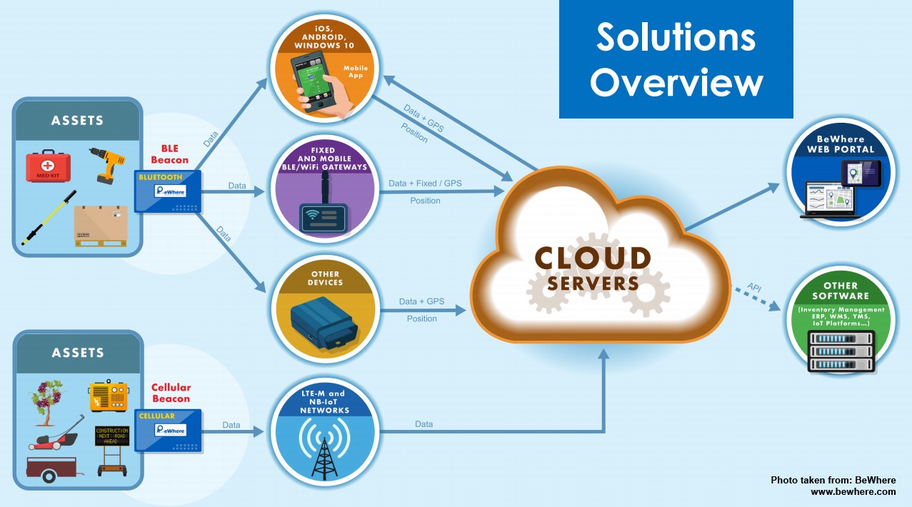
Wi-Fi/Bluetooth beacons have a 3-stage process including: installing devices, installing receivers, and logging into software.

Installing Devices

Firstly, beacons are installed onto an asset. Most installers choose to use zip ties or screws to secure the beacons. However, for discrete installations, some installers enclose the beacons in a case and sometimes use spray-paint to camouflage the unit.

Installing a Receiver

Secondly, a receiver is installed near the beacon. Receivers include tablet & smartphone devices, modem Gateways, and in-vehicle Geotab devices. Receiver devices collect data from beacons and uploads them onto the beacon software.

Using a Software

Thirdly, users log into a portal to view their assets. Users can access this data on either a standalone BeWhere portal or on an integrated myGeotab platform.

The Cellular Alternative

Another beacon device is the cellular model. The biggest difference between this device and the WiFi/Bluetooth device is that the cellular device contains a SIM card.

As a result, the cellular device works without a receiver and connect directly to asset tracking software. In other words, users can skip the second step in the WiFi/Bluetooth alternative where they need separate smartphone, tablet, Gateway, or telematics units.
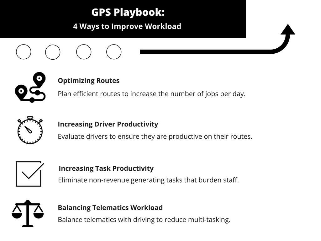
Software Highlights

Finally, let’s review some of the most important software features.

Dashboard

The Dashboard is the beacon’s homepage. Users can view a list of all of their assets, see a live map, and review asset conditions.
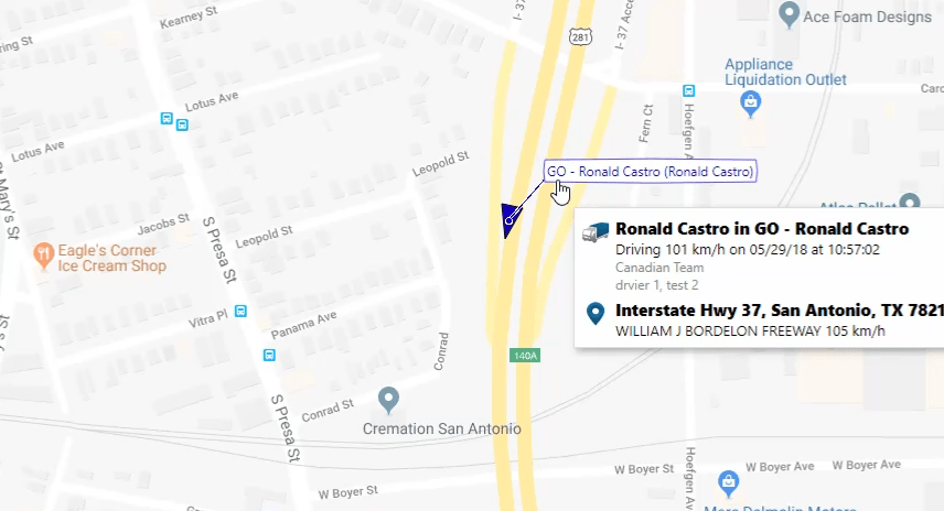
Asset Map

The Asset Map shows all beacons on a live map.

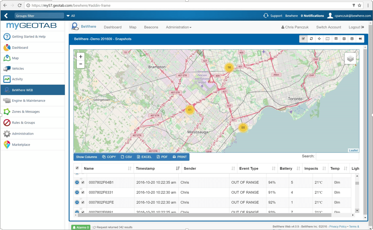
First, let’s take a look at the web platform. The web portal’s map displays beacons over OpenStreet or over satellite. It’s a useful tool to take an asset location snapshot. For example, some businesses use this tool to check which facility contains a certain asset.

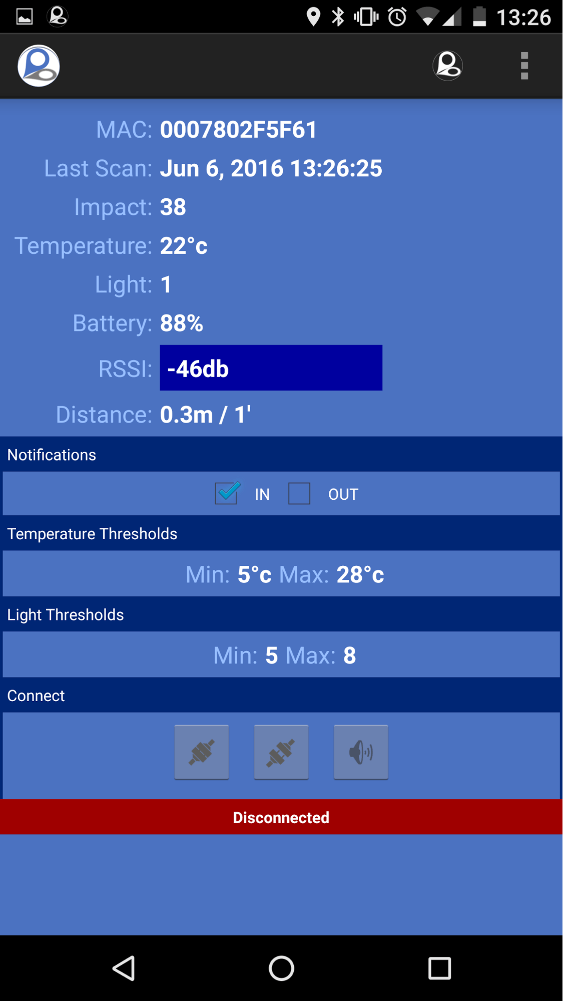
Second, let’s take a look at the phone app. The phone app helps track individual assets. For example, if an employee needs to locate a specific asset, they would use the app to see a proximity indicator and activate the beacon’s LED and buzzer.

Conditions Report

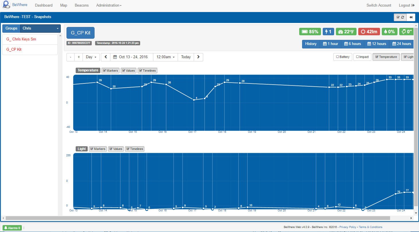
Finally, the beacon’s Conditions Report collects non-location data. For instance, some businesses need to review an asset’s temperature, light exposure, and crash reports.

Click here to view a GoBeacon presentation slide.

Links
Geotab Marketplace: Bluetooth® Low Energy Beacons

Tech Disruption: Restaurant Delivery Vehicle Tracking

How would you order food from a restaurant? For a long time, there was only one way. People needed to call the restaurant and place an order with in-house delivery drivers. Nowadays, people use food order apps and watch restaurant delivery vehicle tracking to monitor their food!

Transformation of Food Delivery

Traditional Boring Food Delivery

Traditionally, food delivery is boring and simple. When people want food, they would simply call a restaurant and place an order. If the restaurant offers delivery, they would send an employee to deliver food to the customer’s home. While this process worked for a long time, it wasn’t perfect. Why?

Typically, if people are ordering food, they are hungry! People want to get food right away. However, between preparing the food and sending a delivery driver, customers might wait upwards of 30 to 60 minutes. That’s not good for those as hungry as a lion!

A New Idea

How can people get faster food deliveries? A new idea came with the rise of phone apps and online orders. Similar to ordering something online, what if people can order food and schedule deliveries online?

That idea took off. Several companies including UberEats, SkiptheDishes, and Just Eat are offering food couriers. These courier services work with a restaurant to process online orders and send local drivers to deliver food to a customer. The business model got so lucrative that some of these companies are worth $50-billion.

How Does Online Food Ordering & Delivery Work?

There are usually several steps. Here is a rough process:

1. Restaurant & Courier Partnership

Firstly, couriers would partner with restaurants. The partnership helps both the courier and restaurant. For restaurants, couriers handle the entire delivery process. This includes setting up an online order menu, processing payment, delivering food, and providing restaurant delivery vehicle tracking. In exchange, couriers receive a cut out of the food order.

2. Customers Order Online.

Secondly, customers can order food online. After setting up an online menu, customers can use an app to browse an online menu, order their food, and pay.

3. Restaurants and Couriers Prepare Food & Delivery.

Thirdly, restaurants and couriers prepare the order. At the restaurants, staff receive and prepare the online order. Meanwhile, the courier receives the order, finds the closest driver, and sends them to pick up the food.

4. Delivery

Finally, when the food is finished, a driver takes the food and delivers it to its destination. Throughout the process, customers can check restaurant delivery vehicle tracking on their app to monitor their food. From placing an order to receiving food, the process can be as quick as 15 minutes.

What if I want to start my own online food delivery service?

This is not a rare thought. There are many online food delivery services. However, potential business owners face two big challenges.

Saturated Industry

The biggest challenge is the food delivery space is dominated by major players. In recent years, several businesses opened and closed because of stiff competition.

In order to compete against big names, new services have to offer something different. For instance, a common complaint against big-name food deliverers is the quality of service. Some restaurants report that drivers sometimes fail to take care of the order and deliver unfresh food. As a result, the restaurant ends up looking like the bad guys. Consequently, some new services are taking advantage by controlling their delivery quality and outcompeting the big names.

Finding Restaurant Delivery Vehicle Tracking Technology

Another barrier is finding the correct restaurant delivery vehicle tracking technology. Online delivery services rely on steady technology to quickly process orders.

As a result, new businesses need to build a system that can: 1) process online orders, 2) track the closest driver, 3) assign them to their job, and finally 4) monitor the delivery process. Thus, new services need to either hire strong programmers or buy specialized software.

Review a case study in the food industry here.

Links
The Globe & Mail: The rise of the instant-delivery lunch
BlogTO: Toronto is getting fed up with food delivery apps

Top 3 EMS Fleet Tracking Needs

Over the past few months, superheros are re-emerging! For instance, we had several debates at GoFleet on which recent superhero movie was the best. Was it Wonder Woman? Or maybe Black Panther or Avengers? However, there’s one thing we all agree on: some of GoFleet’s biggest superheros are our EMS clients. Let’s take a look at how we helped our superheroes with EMS fleet tracking.

Top 3 EMS Needs

EMS fleet tracking

I recently studied our EMS clients and compiled a list of common needs. What were the 3 most common needs? They include:

1. Live EMS Fleet Tracking

2. Driver Habits

3. Workform Management

In this post, we will cover all of these needs.

1) Live EMS Fleet Tracking

Challenge: Meeting strict response rates.

By far, live EMS fleet tracking is the #1 EMS request. And this makes sense! Quick responses to emergencies strongly affects medical success.

To illustrate the importance of response rates, take a look at a EMS compliance report. A Manitoba hospital grades EMS teams by measuring how quickly they respond to each job. For instance, for Priority 1 to 3 jobs, teams need to arrive within 7 minutes if they are in the area.

“Real time response needs real time data,” said a EMS manager. “I simply cannot afford non-real time tracking because I might choose the wrong crew and waste valuable minutes.”

Solution: Live tracking and routing

Live tracking

live ems tracking

In order to meet strict timeframes, EMS fleets use active live tracking. Active live tracking expands on 15 second GPS lag-times by using a predictive algorithm. In other words, the software predicts the next 15 seconds by using a formula from existing data. As a result, EMS users are able to follow live animated vehicle icons.

Routing

After finding a driver, the next challenge is planning the quickest route. EMS teams would then look at route optimization. Route optimization is a two-step process. Firstly, the program chooses the closest available driver. Secondly, the program calculates and shares driver’s optimal route.

2) Driving Habits

Challenge: Safety first!

Another EMS challenge is balancing quickness with safety. “A lot of our passengers are vulnerable,” said an EMS dispatcher. “We might be carrying injured people or children and seniors. Drivers need to be mindful of safety and prevent further injuries to our patients.”

Ignoring safety can lead to severe consequences. Recently, an ambulance was carrying a pregnant woman and rear-ended a vehicle. That caused the baby to be born prematurely, but thankfully, both the mother and the baby survived. However, as a result of the crash, a $117-million lawsuit was filed against the EMS.

Solution: Driver monitoring and driver coaching

Driver monitors

Two common driver monitors include vehicle trackers and cameras. Both of these devices capture driving events such as speeding, harsh braking, and harsh acceleration. Managers then review reports or footages to train drivers and promote safety.

In-cab coaching

In-cab coaching focuses on prevention rather than detection. For instance, some EMS equip their vehicles with GoTalk. GoTalk is an in-vehicle coaching device and audibly alerts drivers when they speed, harshly accelerate or harsly brake.

3) Workforms Management

Challenge: Tightening teamwork

Thirdly, EMS are always looking for ways to improve communication and teamwork. After all, EMS success requires teamwork! After dispatching an ambulance and picking up a patient, another team at the hospital takes care of the patients!

“Hospital staff find it very helpful when they receive more information,” said an EMS manager. “What are a patient’s symptoms? What tools do we need to help the patients?”

Solution: Mobile communication

ems digital work forms

Some EMS teams use mobile apps alongside EMS fleet tracking. Mobile apps are a great way to share patient notes. For example, some teams take pictures of patients or share notes of their symptoms. As a result, hospital staff can prepare for patients before they arrive at the hospital.

Links:
Government of Manitoba: Response Compliance Report
EMS1: $117M crash lawsuit: A dose of reality

CONNECTing with Innovative Fleet Management Technology

I had the chance to attend GEOTAB CONNECT 2018. GEOTAB CONNECT gathers some of the biggest leaders in fleet management, including many Geotab Partners. I had a great time learning about innovative fleet management technology. (And the food was also great – thanks Geotab!)

In this post, I want to share some emerging fleet management technology.

Electric Vehicle Tracking & Some Big News!

At the show, Geotab announced that it is acquiring FleetCarma. FleetCarma is one of the BIGGEST names in electric vehicle fleet management. Their dedicated team is a great addition to the Geotab Network, which is now positioned as an electric vehicle fleet management leader.

Electric Vehicle Wave

The timing of the news made sense. After all, electric vehicles are one of the biggest fleet management trends. Not only do EVs help the environment, they also provide savings. In fact, according to a ROI study, fleets get a payback on their investment because electricity is cheaper than fuel.

A lot of commercial and public fleets are testing EVs. The next question, of course, becomes how to manage EVs and their battery. This is where FleetCarma comes in.

FleetCarma

FleetCarma’s fleet management technology focuses on electric vehicle management. For example, FleetCarma aids with two unique EV challenges.

Picture from FleetCarma

Adding batteries to the fleet management equation. How and when should fleets charge their vehicles? FleetCarma’s tools locate EV chargers and analyze EV usage. It then combines the two data sets and recommends an optimal EV charging strategy.

EV Diagnostics. EVs have their own diagnostic data. For instance, FleetCarma collects and builds battery health reports that optimize EV asset life.

Driver Engagement

Another big fleet management technology is driver engagement apps. Why? Fleets might have access to a lot of data but that data is useless without further action. Driver engagement apps take fleet data and uses it to guide drivers.

Driver Feedback and Training

An example of a driver engagement app is Mentor by eDriving. Mentor uses Geotab data to provide feedback and training.

Feedback

One of the best practices in driver engagement is gamifiying their experience. For instance, drivers can view their Driver Score on Mentor. This Driver Score is compared against a fleet average and against weekly & monthly trends.

Training

Picture from: eDriving

Another best practice is providing live training. Mentor uses Geotab data to auto-create training courses. For instance, let’s say a driver has a low score for Harsh Driving rules. Mentor then sends targeted training videos to coach the driver. As a result, drivers can correct their performance before they get into trouble!

Continuing to Fight Against Distracted Driving

Finally, let’s discuss distracted driving. Distracted driving was a big topic at CONNECT. It makes sense because many fleets are joining the battle against distracted driving.

For instance, a lot of enterprise fleets started using distracted driving sensors or driver cameras. However, what if a fleet has a smaller budget?

Driver Distraction App

Picture from: SafeRide Mobile

Driver distraction apps are a good option for those fleets. SafeRide is a new app in the Geotab Marketplace that targets distracted drivers. Here’s how it works.

1. First, SafeRide identifies a driver through Geotab.

2. Then, when the driver starts going on the road, SafeRide locks the phone. The driver can no longer use the phone except for emergency calls or for allowed apps such as Geotab Drive.

3. Finally, 30 seconds after the car is parked, SafeRide unlocks the phone

Visit the Geotab Marketplace to discover more fleet management technology!

Links
FleetCarma: Electric Vehicle Fleet Management
eDriving: Mentor App
SafeRide

3 Slick Marketing Ideas Using GPS Fleet Monitoring

Welcome to the world of marketing and GPS fleet monitoring! In this post, we will discuss some slick marketing ideas with GPS fleet monitoring.

What is marketing?

First of all, let’s start with marketing. Here’s a quick question – what does marketing mean to you?

Most people would link marketing with ads or coupons. While ads and coupons does fall within marketing, marketing is not just about advertisements!

Marketing is about maintaining a relationship between a business and its partners. In other words, marketing includes creating new products, finding new customers, and keeping customers happy.

How does GPS for fleets help marketing?

In 2018, a lot of fleets are using GPS fleet monitoring to boost their marketing initiatives. For instance, 3 ideas include:

  • Engaging company drivers with in-house contests
  • Creating a new product line, and
  • Acting on customers with geofences.

Let’s discuss each idea.

Idea 1: Engaging Company Drivers

Marketing Challenge: Attracting and retaining talent.

One of the biggest fuel management challenges is finding and keeping good drivers. For instance, consider a recent study. By 2020, Canada is expected to have a shortage of 33,000 drivers. This is because older drivers are retiring and fleets are struggling to fill the gap. Hence, fleet managers are scrambling to find new ideas to keep good drivers.

Solution: Using data to engage drivers.

One trucking company used telematics to build relationships and run contests with drivers.

Firstly, fleet managers used data to market towards the drivers. “We feel that a lot of companies are missing the potential of GPS fleet monitoring,” explained a manager. “Rather than focusing on punishing drivers, we used telematics to monitor things like driver birthdays, job anniversaries, and so on. We then used this data to build our family culture by celebrating employees on internal newsletters.”

Secondly, fleet managers used telematics to incentivize drivers with contests. “We ranked drivers according to contest rules, like who drove the safest or who saved the most fuel,” said the manager. “Drivers enjoyed competing for gift cards and company recognition.”

Idea 2: Creating a New Product

Marketing Challenge: Standing out within an industry.

Auto insurance marketers face a tough challenge. The industry is repetitive; most insurers offer the same plans, just at different rates. Because of the competition, marketers have to think outside the box to stand out against the crowd.

Solution: Using telematics to make a new product.

Some insurers, however, are finding success by creating “premium pricing” plans with telematics. Here’s how the idea works.

First, insurance companies install tracking devices into their customer’s vehicles. Second, these devices track driver safety habits. Finally, the devices create reports to indicate driver performance. In the end, everyone wins. Why?

On the driver side, good drivers are rewarded with steep discounts. It’s a big incentive for them! On the insurer side, the company discourage risky drivers from their portfolio. As a result, the company saves on payouts.

Idea 3: Acting on Customers

Challenge: Communicating with customers on-the-go.

A big challenge for on-the-go businesses is communicating with potential customers. For instance, a company started a non-profit recycling project where customers trade used electronics for other goods at certain sites. How can marketers remind customers to show up when the truck shows up?

Solution: Using geofence alerts with an email and social campaign.

In this case, marketers used a geofence within a marketing campaign. Before we dive into how the campaigned worked, let’s discuss geofences. Geofences are a powerful GPS monitoring tool where users can draw zones on a map. With geofences, users get a vehicle’s estimated time of arrival (ETA) to a location and get alerts when vehicles arrive to the location. Now, how did marketers use this tool?

There were a few steps:

  1. First, marketers created a customer list by promoting the recycling initiative. Potential customers then registered on email and social media lists.
  2. Next, marketers used web analytics to categorize customers into different locations. Each location is then assigned to the nearest geofence.
  3. Finally, as the truck approaches the geofence, the marketing team automated emails to tell customers that their truck is arriving in a few hours.

As a result of geofencing, the marketers improved communication with potential customers and increased their recycling drive success!

Links
EY: The Quest for Telematics 4.0

Playbook: How to Improve Workload with GPS Trackers

A common business quote is “busy is good”. And busy is good! Being busy usually means a business is earning money. In the same way, fleets want more workload because that leads to higher income. In this guide, we will cover 4 ways to improve workload with GPS trackers.

Four proven ways to improve workload with GPS trackers include:

1 – Optimizing routes

2 – Increasing driver productivity

3 – Increasing task productivity

4 – Balancing telematics workload


Optimizing Routes

The first way to improve workload with GPS trackers is to look at route optimization. Route optimization means planning out the best route and increasing the number of jobs per day.

Here’s how it works.

Firstly, managers would look at different factors to determine job routes. This can include distance from jobs, traffic, weather, and customer preferences. Thankfully, GPS programs are powerful enough to calculate routes based on all of those factors.

Secondly, routes are shared with drivers. For a long time, managers sent emails or texts to drivers. However, modern fleet setups now include an in-vehicle navigation guide. For example, some companies have in-vehicle tablets and display routes on those tablets.

As a result of these two steps, managers can squeeze more jobs out of a day.

Increasing Driver Productivity

Another way to improve workload with GPS trackers is to focus on job efficiency. In other words, are drivers productive on their current routes?

An operations manager at a service company explains. “When we evaluate workload, one thing we look at is driver productivity”, said the manager. “We had a few unproductive drivers that took long breaks and did not start their job on time.”


In response to these challenges, the operation manager started measuring work productivity. “We were able to track productivity by measuring the percentage of time drivers spent on the road versus off the road. Soon after, drivers got the message and productivity improved.”

Increasing Task Productivity

Besides looking at driver productivity, another area is task productivity. Are employees spending their time on tasks that generate revenue for the business?

“Our company focuses on deliveries, so for us, making money means driving more. I found that our drivers were burdened with tasks like inspecting vehicles or completing delivery paperwork”, said a delivery business owner. “Sure, those tasks might take 10 or 15 minutes a day. However, that quickly adds up to over an hour per week where we can be on the road and making money.”

One idea is to use automated paperless software. For instance, some businesses use a computerized inspection system. Computerized programs collect diagnostics data from the vehicle and auto-fills inspection forms. Therefore, employees can go straight to the job rather than doing paperwork.

Balancing Telematics Workload

Finally, is it always useful to use telematics? The answer is actually no. There are times when GPS trackers can burden drivers.

Recently, there was an academic study on drivers that got in accidents because of telematics. The study refers to the “Multiple Resource Theory”, which states that humans only have enough visual, cognitive, and manual resources to focus on one task at a time. In other words, some drivers get distracted by their telematics system.


For example, some systems might have audio alerts whenever a manager assigns drivers a new job. The first instinct for some drivers is to check their notifications. Unfortunately, during that time, the driver stops focusing on the road and increases their risk of getting in an accident.

What’s the lesson? Businesses should learn to balance telematics and driving. For example, some businesses set up their system to only alert drivers of new jobs when their vehicle is stopped.

Click here for another article about improving workload with GPS trackers!

Links
University of Michigan: Driver Distraction, Telematics Design, and Workload Managers: Safety Issues and Solutions

Distracted Driving Laws & Policies

Did you know that April was Distracted Driving Awareness month? Distracted driving laws and policies are some of the biggest fleet management topics in recent years.


In this post, we will look at distracted driving laws around the world, sample distracted driving policies in fleets, and finally new anti-distracted driving technologies.

Distracted driving laws around the world

If drinking and driving awareness was the 20th century trend, then distracted driving awareness should be the 21st century trend! Many countries got the same memo and passed distracted driving laws.<p/)


Here are some examples around the world:


  • Canada: Canadian distracted driving laws vary by province. For example, Ontario recently toughened laws by adding a license suspension on top of a traffic ticket for distracted drivers.
  • US: Similar to Canada’s laws, cell phone laws vary by state. For instance, many states ban cellphone use while some states only ban cellphone use for new drivers.
  • Europe: Like North America, many European countries have strict laws. In the UK, your second distracted driving ticket leads to a 6-month license ban.


Clearly, many countries agree on having anti-distracted driving laws. The biggest challenge, like any laws, is enforcing the rules. Unfortunately, even with steep penalties, a lot of drivers still refuse to put down their phones.

Perhaps a good case study is to look at how some fleets enforced their distracted driving policies.

Example – Distracted Driving Policy

By 2018, most fleets have their own distracted driving policies. Some of the steps to implementing an effective policy include creating a policy, educating drivers on the policy, and enforcing the policy.

Creating a policy

Policies should be clearly written. A sample driving policy should include:

  • A mission statement to describe the objective, such as “providing a safe service”.
  • Rules to define how drivers must behave. For example, one business wrote that “drivers must not use cell phones while operating vehicles and must pull over to use their phone”.
  • Finally, there should be clear consequences for breaking the policy.

Educating drivers

After creating the policy, businesses must then educate stakeholders. There are two typical ways to educate drivers – formally and informally.

Formal education means company-endorsed events. For example, drivers should sign an agreement or managers should conduct distracted driving awareness workshops.

Informal education, on the other hand, are non-official but equally effective initiatives. For example, it might include company drivers who become role models and speak out against distracted driving.

Enforcing rules

Finally, the biggest success factor is being able to enforce distracted driving rules. Two common ways to enforce rules include:

Reporting system. A reporting system is when supervisors react to reports. Reports might include traffic tickets, public complaints, or camera footage.

Prevention systems. A prevention system is when supervisors prevent drivers from using phones. Some in-cab technology block cell phone use and prevent drivers from using their phones.


New Technology – Fatigue & Distracted Driver Camera

On a concluding note, anti-distracted driving technology growth is also matching cell phone technology growth.


A good example of such technology are distracted driver cameras. These cameras recognize distracted drivers by using facial scanning technology. ZenduCAM and SmartWitness recently developed a fatigue and distracted driver alert camera that detects events such as:


  • Distracted drivers that take their eyes away from the road for over 3 seconds.
  • Fatigued drivers that are closing their eyes or slumping forward.

Similar to how people stopped drunk drivers with ignition locks, new technology and ideas are stopping distracted drivers!

Links
CityNews: Ontario’s tough distracted driving laws one step closer to taking effect
IIHS: Distracted Driving
AutoNews: Texting and driving bans and fines worldwide

The Science Behind Fleet GPS Tracking

Earlier this year, our partners at Geotab reached an important milestone! Geotab reached 1 million subscribers on its fleet GPS tracking network as of February 2018.

1 million subscribers is an important industry milestone because it shows the growth of fleet GPS tracking as a whole. For instance, Geotab is now used in 137 countries and collects 2 billion data points per week.

Beyond celebrating Geotab’s achievement, this blog explores the science behind fleet GPS tracking. First, we will study its origins. Then, we will look at how fleet GPS tracking adapted and turned to powerhorse that it is today.

Roots of GPS Science

The original science behind GPS tracking comes from a military idea. For a long time, the military needed a way to locate and track their assets. They used a lot of ideas including radar, radios, and everything in between. However, the military did not fully trust those technologies’ reliability or accuracy.

Then, someone thought about using satellites and trilateration. What in the world do those words mean?

The Solution

Trilateration means using 3 satellites to pinpoint a receiver’s location. Confused? Don’t worry, you are not the only one! Here’s how it works.

Satellites send signals to receivers, which are placed in each tracked vehicle. When satellite signals are received, satellites can detect the distance between each receiver and itself. However, a single satellite cannot trace the receiver’s direction.

That’s why 3 satellites work together! Each satellite creates a circle representing all possible asset locations. Then, the 3 satellites overlap their 3 circles. Finally, the exact location would be the intersection between all 3 circles.

And how accurate is trilateration? According to many studies, the most accurate satellite GPS trackers capture locations within 3 meters of the actual location.

Adaptation of GPS

Even after the invention of satellite tracking and trilateration, scientists are constantly looking for new ways to use GPS tracking. Some of the biggest challenges of satellite tracking include:

  • Data lag between communicating with satellites in space, and
  • Costliness of satellite solutions.

One of the biggest innovations is shifting from satellite to cell towers. Scientists realized that cell towers are more readily available than satellites. Also, they eliminate data lag and provide real time tracking at a lower cost!

For that reason, many GPS trackers nowadays have a built-in SIM card and use cell towers to provide live tracking.

Big Data & Fleet GPS Tracking

Finally, it’s worth noting that the science of GPS tracking is still adapting. Scientists are constantly finding new and better ways to use GPS tracking.

Perhaps the biggest trend for GPS’s future is leveraging big data. Big data means collecting and owning data to make decisions. In other words, vehicle trackers collect and use much more data than standard fleet tracking.

A great example would be CMMS, a software that automates the maintenance process. CMMS uses GPS big data to diagnose vehicle issues. Then, the software creates work tasks for company maintenance staff – and no human input was needed throughout the process!

Links
Geotab: Geotab Celebrates 1 Million Subscribers
GIS: Trilateration vs Triangulation – How GPS Receivers Work

Satellite Fleet Tracking System

A 360° View of Your Business 24/7

satellite tracking system is the ultimate device to manage your mobile resources whenever and wherever they go.

GoFleet’s satellite tracking system supports your assets in the field, whether it’s a container or trailer. Our easy to install system features no wires or antennas and can be placed within the asset with either industrial adhesive or a screw mount. Tracking your assets has never been easier.

The satellite tracking system provides fleet managers with pin-point accuracy for location information and activity information. Our system provides updates hourly while your asset is in continuous motion and daily when it has stopped. This powerful information can be used to keep you informed about how your assets are being handled and identify any issues that may arise.

GoFleet is Your Eyes in The Sky

How it Works

Keeping up with the latest in technology, we use a military grade Smartone LP powered by a AA Lithium Battery pack to keep conntected to the satellite network. This allows our GPS units to perform under the toughest conditions so your fleet and assets can operate almost anywhere. The smartone unit can still operate in temperatures as low as -40° to as high as +85°. The system will even send you alerts when the battery levels are low. You can sync as well with cell phone tracking or our fleet tracking so you can integrate all of your systems together.


The Power of Data in Satellite Asset Management

Data collected from our satellite fleet tracking system is vital to reducing costs by damages, or delays in transit. Knowing exactly where all of your assets are in the field covers you and your fleet from errors and track performance long term. Identifying choke points in your processes or knowing when an asset has been idle for too long can help add to your bottom line.

Let GoFleet’s system help you!

Get pole to pole, round the globe coverage and reliable intelligence with GoFleet’s live satellite tracking system. Our support team is eager to answer your questions and help you get the most value out of our systems. Contact us for more information and start saving.

How to Use Privacy Mode on Fleet Vehicle Tracking

What are your thoughts on fleet vehicle tracking? You might get different responses when talking to different people.

For instance, some businesses will tell you that fleet vehicle tracking is a necessary tool. Fleet managers are able to plan their work, measure assets, manage drivers, and reduce downtime.However, some drivers will strongly disagree. For them, fleet vehicle tracking is a spying tool. Some drivers might nicely say that “it invades my privacy” while others bluntly call it “a piece of #@#@”.Is there a medium ground?

Privacy Mode for Fleet Vehicle Tracking

Some fleet vehicle tracking systems like Geotab have a Privacy Mode. Privacy Mode is a tool that disables vehicle tracking functions such as live map monitoring, trip history reports, and driving habit reports during “exception periods”.And what are exceptions? Exception periods are any defined time periods. For example, a business may label anytime between 5pm and 8am as an exception period.

How do I use Privacy Mode on Geotab?

A great resource is Geotab’s User Guide. The guide outlines how to enable Privacy Mode, disable Privacy Mode, edit Privacy Mode and set up exemptions. Here are some highlights on how to enable Privacy Mode:

1) Firstly, from your main menu, go under Rules & Groups and select Rules.

2) Once you are on the Rules page, go to Exception Rules and press Add.

3) Then, set your exception conditions by pressing Conditions.

4) Go to the Notification tab, select More, and then click Assign as Private/Not Private.

5) Finally, save your new rule by pressing Add and then selecting Save.

What does Privacy Mode Look Like?

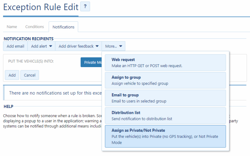
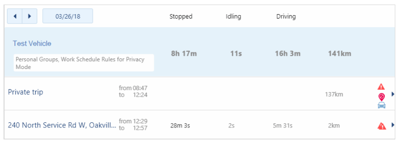
When vehicles are on Privacy Mode, the Geotab unit will not record any GPS related events. In trip history or driving behavior reports, any trips under Privacy Mode will be marked as “Private Trip”.

Who Should Use Privacy Mode?

Privacy Mode would make sense in a few situations. Here are two examples.

Unions

Some fleets are restricted by unions. For example, the Massachusetts State Police union recently objected against the department’s fleet vehicle tracking project. According to the union, the police department acted in bad faith because they never gave the union a chance to negotiate a GPS tracking policy. In some fleets, the union ends up winning. However, because of Privacy Mode, fleets were able to keep vehicle trackers in their vehicles. As a result, even though fleets couldn’t measure driving productivity or safety, fleets can still monitor things like preventative maintenance.

Personal vehicles

Another good example includes employees that use personal vehicles. In some companies, businesses will ask employees to use their own vehicles for business. However, the company will reimburse drivers for fuel. The next question, then, is how can companies measure fuel reimbursement and compensation? After all, since employees are using their personal vehicles, it would be unreasonable to track employees on their personal hours. Privacy Mode allows businesses to make that compromise. Employees can turn off tracking during their personal hours while businesses can still track work hours.

Links
The Boston Globe: State Police union files complaint about GPS vehicle tracking