school bus, fleet, gofleet, fleet management, school, back to school, bus eta, telematics

Spotlight on Telematics, Bus ETA and Back to School: A Conversation with Kemal Leslie

Kemal Leslie, a strategic consultant to GoFleet, talks about Lord Selkirk School Division’s biggest pain points, and how GoFleet’s comprehensive and integrated telematics solutions solved some of their biggest back to school issues.


Tell me a bit about LSSD and the kinds of things they were looking for.


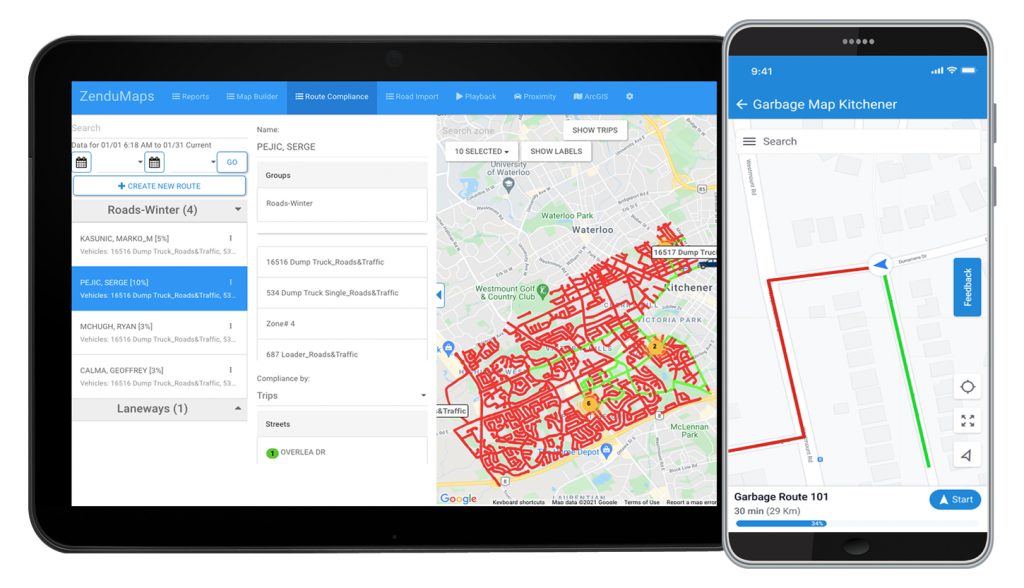
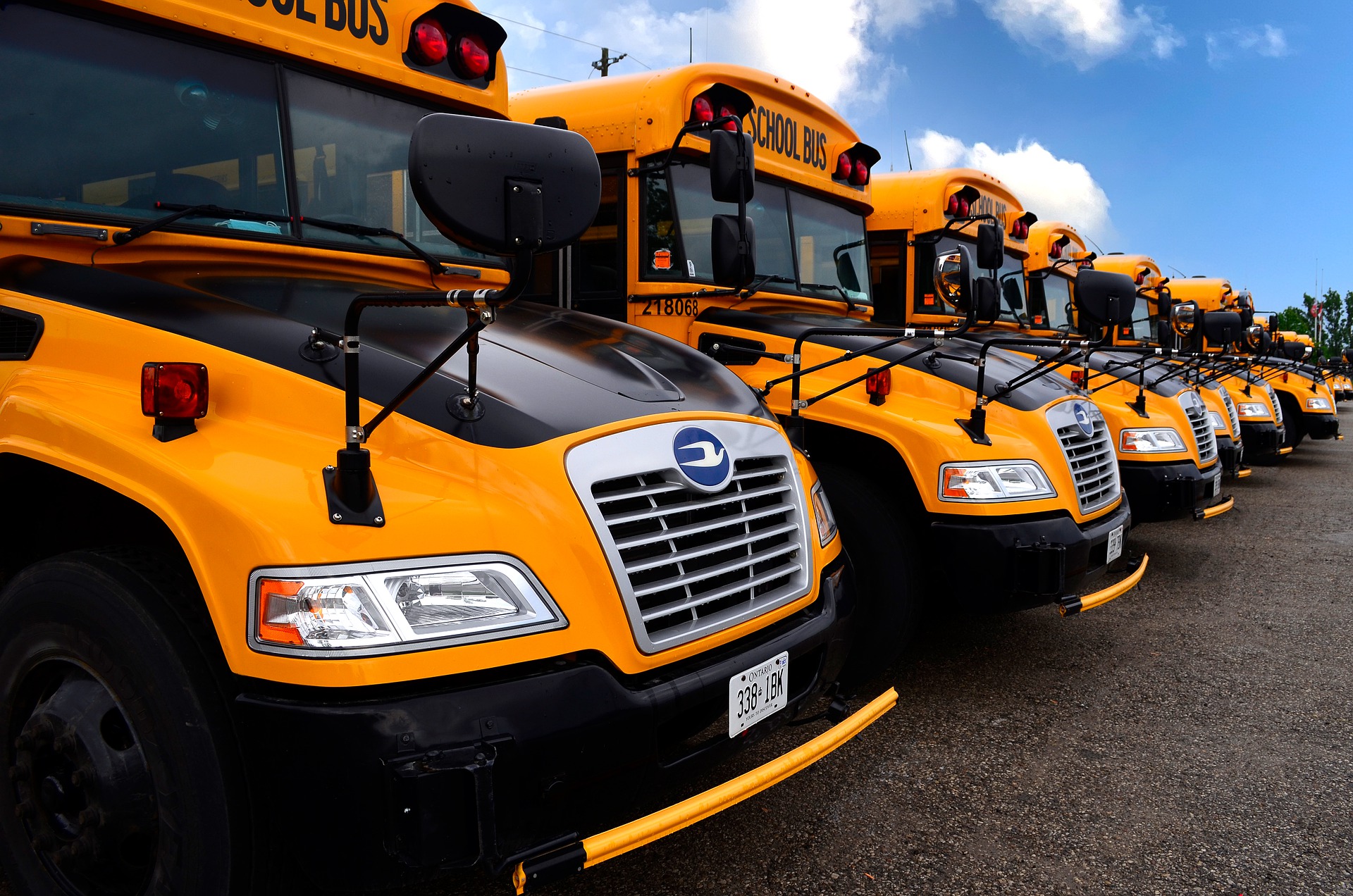
KL: They began working with GoFleet a few years ago to help them manage their bus fleet maintenance and location tracking. This also included management of driver operational safety. 


How did Bus ETA factor into the equation?


KL: At that time, they were also looking at Bus ETA as a solution, where a student or parent of a student, for example, could know when the bus is on its way to pick up or drop off, as well as the whereabouts of that vehicle. This has become a more popular solution over the last, I would say, five or six years, where parents or students want to know when to arrive at the bus stop. 


So it seems that Bus ETA also offers peace of mind?


KL: Well, for safety and security reasons, they received feedback that parents want to be able to track kids’ travel to and from school. They wanted an easy way to oversee their safety. That’s what the Bus ETA application really was about.  


What were the other components of your proposal?


KL: At that time, GoFleet implemented not only their bus tracking and status reports, but had also integrated another solution called On Command Connection with their Geotab telematics system, which is a diagnostic maintenance offering under Navistar. Their maintenance provider can track their buses and advise if any need to be repaired based on automated scheduling and alerts from real-time vehicle data; their maintenance team can call in a repair just by looking at the status report that’s provided through On Command.

Finally, Transfinder became the next third party integration for this solution. It’s a mobile application that tracks where the student is; if they are on the bus, when the bus is arriving, that type of thing. The system actually utilizes Geotab telematics data to manage the reporting within the application where the student might be at any given time, or where the bus is in terms of its daily trips.


So in terms of the evolution, it started as a fleet management application to manage the hardware, the equipment, location status, etc. And then student tracking for parents was integrated to centralize everything within their GoFleet solution.


That sounds really comprehensive. What are some other applications for this system outside of LSSD?


KL: Well, the entire solution could serve many verticals really, either in part or as a whole integrated solution. The fleet management piece can apply to any industry that requires management of their own automated fleet — it could be heavy equipment, trucks, small vehicles — any of that can be adapted to use this functionality. 


The same goes for the maintenance piece; to be able to connect to and manage the fleet without needing to bring in the vehicle, to have diagnostics established if there’s a problem with a unit and it needs to be called in. Those things can adapt to pretty much any industry.  


And what about Transfinder?


KL: I think that the Transfinder solution, as it relates to tracking when a vehicle is coming to pick someone up, certainly has its application in schools. But it would also have applications for other transportation clients, really any type of privatized or public transportation, the TTC for example. There will always be people who could use an app to tell them when to expect their ride. 

All in all, I think it’s a pretty robust solution; the equipment management piece, the maintenance piece and the transportation communication piece. Operators benefit from having a really strong, interconnected solution that provides important efficiencies.

Interested to learn more about how GoFleet’s solution could help your fleets unique needs? Contact us today by clicking the button below!

government fleets, telematics, gofleet, fleet management, productivity

How Government Fleets Can Benefit from Telematics Solutions

Local government and public works agencies rely heavily on datasets to improve their operations, satisfy their constituents and plan their community more effectively. What typically remains top of mind for most government agencies is the safety and satisfaction of their citizens. To this end, telematics can help achieve these goals by providing visibility into the inner workings of their services and fleets, creating a partnership with the public rather than an autocracy.


From vehicle tracking to functionality, telematics can have a positive impact on government operations. For example, a winter maintenance fleet manager can have specific data at his fingertips, including when plowing occurred and when, and even how much salt is left in a vehicle. The right telematics solution will help save costs, improve safety and overall operational efficiency, and help fleet managers monitor the status of services while tracking their assets on a single platform. Here’s how telematics can improve your government operations.


Single sign-on


Not all government vehicles are plows and spreaders, which is why it’s important to be able to manage all assets within your organization through one system. Managing your entire fleet through one platform reduces training, reinforces information and highlights inefficiencies.


A centralized, cloud-based “single source of truth” allows you to track assets in real-time while managing their maintenance and controlling costs. Telematics can automate your processes and eliminate hours of manual data processing, giving you more time to focus on decision-making, training and efficient operations.


Automate and manage your assets


Government organizations provide essential services and critical infrastructure that support the daily activities of residents and businesses. In addition they are responsible for maintaining service level agreements, infrastructure planning, policy and ensuring the best use and deployment of expenditures and assets.


Because government fleet managers and leaders typically oversee a diversity of vehicles and assets (usually in the form of unique GPS tracking), an integrated telematics solution would offer full visibility into the operational data of all government vehicle types on a single platform, providing the tools to maintain compliance and road safety while reducing costs.


When you increase your fleet’s capabilities, you can measure material usage and ensure equal delivery of services within the community. Ultimately, these datasets lead to lower costs and a reduced environmental impact.


Asset health


Whether seasonal or otherwise, repairing infrastructure and conducting road work is tough on vehicles and assets. Telematics allow you to monitor asset performance to ensure you get the most out of them. When you track asset utilization, such as average daily mileage and service history, you can increase their lifespan and improve your bottom line.


The right telematics solution will compile both historical and real-time data usage so you can proactively decide how best to maintain and use your assets. From forecasting future repairs to predicting vehicle replacement, the fleet reports offered from telematics data give valuable insights into performance and maintenance, giving you a holistic overview of your fleet’s health.


Increase productivity


The unfortunate truth about many government operations is the tendency towards using old management methods, such as spreadsheets, that offer little to no insight into asset usage. When you don’t know the health of your fleet, you can’t prepare for potential work, which can lead to unplanned downtime and reduced efficiency. It is essential to have an automated telematics management system that can track and manage your fleet in real-time so you can maintain productivity.


Manage public perception


In the end, government fleets answer to the governed. Give your community access to visibility and help fight false claims with historical reporting and analytics. Provide proof of vehicle location and services rendered; show your constituents how to track vehicles themselves with a public map they can easily access and maneuver. Transparency can foster a positive relationship with the public and improve overall satisfaction. 


Use telematics to turn your fleet data into insights and action. Support your key government business drivers, including asset management, compliance, accountability, and efficiency. Contact your GoFleet specialist for your special offer, and schedule a demonstration today.

zendumaps, gofleet, gis, mapping, winter maintenance, waste management, city works

6 Industries that can benefit from ZenduMaps

By now, you’re familiar with the ZenduIT mapping software system that we offer ZenduMaps, which offers real-time location-based operations management that benefits fleets across a number of industries. The use of telematics is becoming increasingly prevalent among fleets, and managers of all kinds are beginning to understand the benefits of tracking vehicle location, driver behavior, work planning and so much more.


While the more obvious applications for ZenduMaps might include winter maintenance and seasonal road work (read more about the advantages of ZenduMaps for public works here), there are a number of operations that could benefit from this powerful fleet management tool. 


City Planning


Geographic Information Systems (GIS) have been very successful tools for urban and rural planning over the last several years. Whether the task is planning for new roads, working out local taxes or planning the next desirable neighborhood, the data gathered from ZenduMaps can help develop a new city, track its expansion and plan the direction of future growth.


Using GIS data, cities can manage planning, analysis and reporting — all factors that are necessary for successful building. With this secure, cloud-based software, stakeholders across local government and private organizations can be engaged to ensure that zoning, city bounds, street names and more are accurately and efficiently mapped. The platform provides geospatial data sets that deliver more effective solutions for planning management and city operations. 


Waste Management


The ZenduMaps platform has integrated tools to help improve productivity and reduce costs, both of which address common challenges within public works, but can be applied specifically to waste management. The public sector has a unique set of needs; waste collectors have the double task of clearing garbage quickly, efficiently and on a regular cadence, while appeasing constituents . 

ZenduMaps can manage and optimize waste collection vehicles, increase productivity and encourage fleet managers to adhere to waste collection schedules. The routing function increases fleet visibility and efficiency, while optimizing pickup schedules and litter control. Moreover, scheduled pickups and routes are searchable and viewable by the public, which fosters goodwill and keeps citizens informed.


Government


Government contracts represent some of the biggest use cases for ZenduMaps, as well as some of the greatest accountabilities. In this instance, GIS data can track all vehicles, assets and routes on a live map, allowing you to receive alerts based on predetermined triggers. The platform can also produce maintenance schedules and reports to reduce fuel costs and maintain vehicles before a problem arises.


The mapping of service locations and routes offers real-time feedback on completion rates and allows government agencies to proactively detect missed services or insufficient resources before they become a problem. 


To help manage public perception, the public can gain visibility into historical reporting and analytics for service verification, including work location with date and time stamps. By benchmarking the capacity of staff and equipment, an agency can verify the need for additional resources, or reallocate existing resources to other projects.  


Transportation


GIS data is commonly used for managing existing transportation issues while allowing those agencies to plan ahead for new roads and routes. The ZenduMaps solution offers fleet managers full visibility into the operational data of all government vehicles on a single platform, and provides the tools to effectively reduce costs, maintain compliance and ensure road safety.


Water Utility


One of the most critical areas for geospatial technology is water asset management. Mapping solutions provide water utilities with improved asset management capabilities. Creating smart, connected networks with water utilities can ensure clean drinking water for a community, a city, or the global population. In this case, agencies can accurately and efficiently maintain the utility’s infrastructure to help meet the increasing demand for water.


In addition to tracking water pressure and monitoring potential leaks, GIS mapping technology plays a vital role in digitizing water networks, and can help provide valuable insights into locations and assets, including pipes and reservoirs. Data gathering, both historical and current, can help water utilities plan new infrastructure projects and provide a complete picture of the utility’s performance. Water managers can use this technology to improve service levels and ultimately improve customer satisfaction. 


Agriculture


Pursuant to the development of water utility infrastructure in cities, GIS data also holds sway in rural areas where water is essential to the agricultural industry. The availability of water directly affects crop production in a given region; GIS mapping can produce efficient techniques for farming, identifying crops and determining yield. GIS data can also help analyze soil data, which increases food production.


The goal of a mapping platform is to reduce costs while improving efficiency, operational effectiveness and quality of service. Speak with one of our consultants about implementing a solution for your industry. Contact us now for your free trial!

3g, fleet, networki, 5g, lte

The sun is setting on 3G. Is your fleet prepared?

Major wireless network carriers are in the process of phasing out their 3G networks – commonly referred to as the 3G sunset. This is the period when wireless carriers will shut off their 3G services to make room for upgraded connectivity. When this occurs, all devices that are not 4G (LTE) compatible or higher will no longer receive cellular service, The period when wireless carriers make room for upgraded connectivity by shutting down existing 3G services is most commonly referred to as the “3G sunset”. All devices that are not 4G and LTE compatible (or higher) cease to receive cellular service after the transition is complete. 


While the 3G network shutdown is not expected to be completed until the end of 2022, wireless network carriers are already starting to phase out their 3G networks. With 4G and LTE services now on the horizon, the time to plan ahead is now.


What does the 3G sunset mean for my existing telematics solutions?


The 3G sunset means different things to different fleets; for fleets that haven’t yet upgraded their devices, it could mean loss of connection to vehicle and driving data. To prevent loss of data transferring (and signal), fleets with 3G vehicle tracking devices will need to upgrade to 4G devices. 


Conversely, the upgrade to 4G and LTE will provide users with a wider range of capabilities, including enhanced connectivity and speed, faster download speed and wider support for streaming and video interactions. Unfortunately, this means that 3G devices will no longer work or be supported.


What can I do to prepare?


Fleet managers will want to check all of their installed devices to determine how many still operate on a 3G network. You will definitely want to consider reaching out to your GoFleet Account Manager to determine whether your devices are 3G or 4G, as well as what plans are available to you in order to avoid disruption of service. 


Fortunately our team prides itself on expandable, scalable business solutions for fleets of all sizes. Your account manager will be more than happy to work with you to create an installation plan for your new 4G devices to ensure a seamless transition.


Fleets can start protecting their technology investment by selecting devices and telematics solutions that are scalable and adaptive. Don’t be caught in the middle of a massive service disruption by assuming the 3G sunset doesn’t apply to your fleet. The move towards 4G — and increasingly 5G — is inevitable. Knowing what lies ahead and adopting flexible technology will help your fleet stay agile.

cityworks, mapping, zenduit, zendumaps, gofleet, government, fleet

A Beginners Guide To Cityworks And Its Benefits

In the latest integration of systems that improve workflow and increase transparency among its stakeholders, ZenduIT has merged processes with Cityworks technology to create a veritable mapping superpower, aimed at engaging not only city workers, but regular citizens as well. By leveraging geographical information systems (GIS), Cityworks uses data to connect previously siloed city systems and ultimately build safer, smarter and more resilient communities.


What is Cityworks?


A geographic information system creates, analyzes, maps and manages all kinds of data; it connects data to a map, integrating “where things are” with descriptive information, such as “what things are like there”. It helps us understand patterns, relationships and the context within a geographical location. GIS creates fertile ground for mapping and analysis that can be used in virtually every industry, improving communication, efficiency, management and optimal decision making. 


Cityworks helps you fully use your GIS data and improve operational efficiency. This leading web-based GIS asset management system tracks, manages, scores and analyzes the assets that comprise your infrastructure. Designed to help city-run agencies streamline their workflows, track data and improve communication, Cityworks helps local governments and utility agencies get work done.


Scheduling work activities


Cityworks provides a detailed foundation of asset management. Cityworks allows you to combine assets based on key factors such as age, type and location. These groups can be used to create and schedule various maintenance activities.


Mapping Tools


Because Cityworks is built exclusively on GIS, you can easily map open service requests, or work orders of varying types. These tools empower and encourage you and your staff to use asset data and create an integral part of the work management process.


Mobile Data


We live and work in a mobile-centric environment. Your data should be portable as well. Cityworks has a number of tools to help your crew access and update valuable content on site and on the go.


Work Orders


You can track work that has been performed on an asset at any time throughout its entire lifecycle with Cityworks. Users can search for work orders and view them on the GIS map. Track active or overdue work orders and monitor work, regardless of whether it’s associated with a specific project, contractor or task.


Improve Communication


Once you can track asset data and work history, you can better share this information with staff, cross-functional departments, and public citizens. Cityworks users have created solutions to improve communications across a number of tasks, including repairs, inspections, emergencies, permits and resident requests or inquiries. 


How Cityworks can benefit your city


Fostering goodwill


Often, information silos and archaic systems prevent a city’s infrastructure from working efficiently. ZenduIT works synergistically with Cityworks to improve communication between a city and its constituents. Imagine having a work management tool that creates digital public maps where citizens can report issues in real-time. 


ZenduIT’s mapping interface, ZenduMaps, allows the public to do exactly that. No more long, laborious 3-1-1 calls. Whether there’s a spotted pothole or burst pipe, users can simply click on the digital map and feed that data to the proper department. When they’re shared, intelligent monitoring tools foster goodwill between a city’s inhabitants and the infrastructure that’s there to support them.


Automated processes and applications


Connecting technology offers better tools to communicate with the residents within a city. For example, Cityworks can streamline the process of tracking property stabilization by making data and inspection status easily accessible and transparent across departments. This system of record keeps both residents and city employees in the loop and fosters efficient workflows.


Similarly, ZenduMaps can create a public map, whereby residents can report issues or render complaints in real-time, either on the site or using their mobile devices. Issues are submitted to the proper city department, and the tool can now allocate work to the proper crew, or feed into a third party work order management system such as Cityworks. Consider the applications for not only road work, but waste management and winter maintenance. Most cities currently operate under a “search and fix” process, but with strong citizen engagement and specific GIS data, the continuous course of mapping and fixing can create proactive, predictive patterns for future work, patrolling and route optimization.


Cityworks and ZenduMaps work together to drive public engagement; that component of citizen involvement helps create a dynamic and transparent workflow, where everything from reporting issues to taxes can be managed interchangeably, with input from the people who are most impacted.


Work management tools save time and generate efficiencies. When they’re connected, these same tools can also create goodwill within a community and improve some of the city processes currently in place. Together with ZenduMaps, Cityworks will help you build safe, resilient and smarter communities.

zenduone, gofleet, mobile, app, zenduit, zenducam

ZenduONE Can Grow Your Business — Here’s How.

In a recent webinar we launched and shared information about the ZenduONE Mobile App and how it can be leveraged by fleets to streamline performance. To briefly recap, ZenduONE is the latest evolution of our streamlined performance and end-to-end business solutions. Users who download the mobile app from iOS or PlayStore can access all of the digital business solutions while on the move — in just a few clicks.  This comprehensive dispatch, operations and accounting system enables fleet managers to leverage their existing dash cams to review video footage on the go. 

ZenduONE is, above all, part of a group of scalable service offerings that can grow and adapt to your ever-changing business needs. Now, more than ever, you can get the content you need, without scouring hours of footage or reviewing irrelevant alerts.


Scale up or scale down


With ZenduONE, you can access all of your solutions from a single app. The goal of the app is twofold: providing visibility to drivers into their performance on the road in real-time, and becoming a convenient tool for fleet managers to expand their fleet business while gaining valuable insight into fleet productivity, operations and safety.


All of your favourite ZenduIT apps can now be accessed on the ZenduONE platform: Asset, Video review, TimeCard, ZenduMaintenance, ZenduReports, and so much more. A range of 15 fleet applications are currently available to install with a single click — and more on the horizon. You can rest easy knowing that all of your users will be fully supported.


ZenduIT has modularized the ZenduCAM platform into separate entities in order to host them all on one app and more importantly, keep your productivity organized based on the functionalities that matter to you.


What does this mean for your business? ZenduONE accommodates your shifting priorities and organizational needs. If you’re a fleet manager, you can review video footage based on the alerts you’ve predetermined, process a work order for vehicle parts, dispatch a driver, review time cards, or find asset locations on a map; and you don’t ever have to be at your desk. Whether you have a large fleet or are just starting out, ZenduONE allows you to pick and choose the workflows you need, when you need them.


Interested in learning more about how ZenduONE can provide a fully-integrated, scalable workflow experience? Schedule a demonstration with one of our consultants and try us for three months — absolutely free!

GoFleet Offers Vehicle Dash Cam Solutions Across A Number Of Industries

Generally speaking, commercial dash cams are well-suited to answering “when” and “where” questions around accidents or other incidents involving your vehicles. When paired with a top-tier telematics platform, your dash cam system can provide a deeper dive, answering the “why’s” and “how’s” of driving behaviour on the road. Dash cams ensure and improve safety for drivers and vehicles, while providing peace of mind to the people who employ them. 


By now, you’re likely familiar with GoFleet’s dash cam offerings. What might be less familiar is which scalable, comprehensive solution will work best for your fleet. Depending on your requirements and the industry in which you operate, the answer can get complicated.


Whether you have a handful of vehicles, or an entire cavalcade, both our dual-facing and multi-camera options help correct similar issues across nearly every fleet industry. “From my experience, it’s not about fleet size. For example, a client might want a four-channel setup, because they want a camera solution that has a nearly 360 degree view to get a better understanding of who’s at fault,” says Ron Sabbun, who works with Strategic Partnerships at GoFleet’s Partner ZenduIT. “Our product sales depend on two main criteria; customer requirements, and the industry they’re in.”


With a number of device solutions, paired with a robust Trax platform that can monitor vehicles, report on and interpret driving data in real time, the applications for commercial dash cams seem nearly limitless. In this post, we’ll look at some of the more universal use cases for commercial dash cams that GoFleet can solve for. 


Driver Exoneration


Whether you work in transportation, waste management, hospitals, government, field services or passenger transport, a time may come when your driver is involved in a traffic accident.


“One of the major reasons customers elect to get dash cams is to get video evidence of any incidents that occur while their driver is on the road,” says Sabbun. “In an accident, they want to get a better idea of what led up to the event, the driver’s reaction during the event, and who was at fault.”


Not coincidentally, Sabbun points to passenger transport as a growing industry that requires the use of dash cams. Unlike public transportation, passenger transport describes the privatized movement of passengers on a given network, such as transporting people with special needs, or ferrying executives around. “These companies really understand the liability process if their drivers get into an accident. Not only does the driver have to prove that they were not at fault, but they require evidence that their passengers weren’t injured.”


Preventing Distracted Driving


While issues of fatigue or driver drowsiness tend to be risks associated with trucking, distracted driving can affect any driver in any industry where vehicles are employed. Dual camera systems with both driver and road-facing camera views would be a popular choice where it’s a requirement to monitor and gauge a driver’s behaviour inside the cab, especially as that behaviour relates to an accident. GoFleet’s cameras offer advanced alerts for fatigue and driver distraction, which focus on a driver’s physical indicators, such as his facial features and the direction of his gaze. For added safety, the camera will produce an audible alert in the event of distraction; a great tool to keep your driver’s eyes on the road where they belong.


Content Review


Commercial dash cams display video relating to an event of interest for the purpose of review. Events of interest can either be an on-demand request that has been flagged by a fleet manager, or automatically triggered by a preset list of notifications. Either way, a fleet manager’s time, the number of events or notifications, and the number of vehicles sending data back to the business are all factors that can contribute to a bottleneck in the review process. Having the right tools to sort through the most critical events for review is essential. The content review process can even be simplified by GoFleet’s Managed Services, which allows fleets to work with industry consultants who provide recommendations on how to increase safety and sort through dash camera footage for you.


Generating Reports


Dash cams can generate a lot of data within a very short time frame. Distilling that information into key metrics that measure how drivers and fleets are performing over time is essential to fleets big and small. GoFleet’s telematics system will provide reports such as driver scorecards, which help measure how a driver is performing over time, as well as how he compares against his fellow drivers. Scorecards can provide the foundation for both reward incentives and coaching programs. 


Providing Feedback


Coaching and feedback between drivers and fleet managers create value and can provide a significant ROI. Depending on the size of your business, you can initiate a review and/or coaching session based on metric-driven reports, either in-person or by supplying drivers with a formal review checklist. This list compiles shortlisted events and videos, as well as notes and comments; completion of a pending review can be part of a driver’s to-do list before starting the next trip. 


Opportunity for feedback ensures that our solutions make your job easier, while improving workflow and increasing overall fleet safety. Reporting and feedback are scalable solutions that can work in virtually any industry that employs a commercial fleet.


Reducing Operational Expenses


Your fleet can realize major savings by implementing commercial fleet dash cams. Outside of exonerating drivers, there are significant savings around fewer traffic violations, reduced insurance premiums and lower maintenance costs for your vehicles. There are also a number of studies that illustrate a correlation between safe driving and better fuel efficiency (examples here, here and here).


Driver Retention


There has long been an impression of dash cams as a means to surveil drivers. While the primary purpose may be recording and monitoring driving behaviour, the process of reviewing content doesn’t have to be punitive. Rather, dash cam telematics can create recognition programs within your fleet, in addition to capturing accidents. In fact, driver scoring encourages your fleet to maintain positive behaviour and create a work culture based on compliance and safety, a key factor to driving engagement within your team.


Conclusion


From a growing awareness of the value of commercial dash cams to the availability of cutting-edge hardware with a host of functionalities aimed at keeping drivers and vehicles safe, dash cams are now the norm for commercial vehicles and fleets of all sizes. As the choices keep expanding, so does the analysis process. Selecting the right dash cam solution requires you to look at the combination of hardware and software holistically, within the framework of your fleet’s requirements. Thankfully, GoFleet is here to assist you with navigating your decision-making journey.


Schedule a demonstration and get a FREE trial when you contact your GoFleet consultant. There’s never been a better time, call now!

salespeople brainstorming

15 Characteristics of Successful Salespeople

Successful Salespeople: 15 Common Characteristics

A successful salesperson has a special set of characteristics that are used to make sales. Some people have natural talent; however, these characteristics can be learned for anyone to be successful.  According to The 15 Characteristics of People Who Succeed at Sales, a successful salesperson has the following traits:

1. Conscientiousness

The majority of successful salespeople are conscientious. They take a lot of pride in their job, they are organized and they are efficient. They will continue to do their best at their job no matter what happens.

2. Initiative

Successful salespeople do not wait to be told what to do, they are go-getters. They will constantly strive to keep doing what is necessary to sell a product.

3. Respect

Top salespeople respect the customers. It is extremely important that the customers are treated with respect at all times, regardless of the situation. Even if the sale is unsuccessful at the time, treating the customer with respect may turn them into a future prospect.

4. Good Listening Skills

The best salespeople have great listening skills. They listen to what the customers’ needs are to help them figure navigate their options and provide the most effective solution.

5. Persistency

Salespeople must be persistent and confident, yet not overly pushy. If a customer says no, a persistent salesperson has more chance of making them change their mind down-the-line.

6. Trainable

Previous sales experience is not as important for a successful salesperson as their ability to be trained to do well in your company. They must be able to adapt to your company culture, processes, customers and sales goals.

7. Positive Attitude

A customer would rather make a purchase with a salesperson who has a positive attitude then someone who is negative or down. Positivity is contagious – it is easier to approach a customer when their positive attitude exudes from them.

8. Passion

Successful salespeople need to be passionate about their job. When they enjoy their job, they can easily share the company vision with your customers and potential customers, and this will be conveyed in a genuine manner.

9. Resourcefulness

It is important for a salesperson to be able to shift gears when a potential sale is not going the way they want. They need to be resourceful and change the approach quickly and creatively.

10. Independent

In general, most salespeople work on a commission basis, so they must be independent in order for them to meet their sales goals. They must be self-motivators and do whatever it takes to achieve their own success.

11. They Ask Lots Of Questions

High performing salespeople ask a lot of questions when they talk to potential customers. They not only what to find out what the customer needs, they want to make the customer comfortable, feel valued and build a long-term relationship.

12. Time Management Skills

Top salespeople are able to effectively manage their time, so they have the most opportunities to secure sales. They don’t rush opportunities and they do not miss deadlines.

13. Personable

Great salespeople get along with everyone and enjoy dealing with people. That is why many salespeople are involved with many organizations and local events.

14. Overachievers

Most salespeople are natural overachievers. They go above and beyond what is expected from them, and they are generally pushing for more of everything – more clients, more people, more money, more work, etc.

15. Always Prepared

A salesperson must always be prepared for any situation that could occur when they meet a customer or potential customer. Every customer, every situation is different and salespeople will need to creatively navigate every unique situation that arises.

Advanced Driver Assistance System, fleet, gofleet, dash camera, dashcam, ADAS

Does Your Fleet Need An Advanced Driver Assistance System?


The automotive industry continues to respond to consumer demand for enhanced safety features in an ongoing quest to develop more secure, automated vehicles and a safer driving experience for the people who operate them. The race to develop smarter, safer personal transportation has taken us from seatbelts to self-driving cars; it would seem the finish line is somewhere on the horizon.


In the latest iteration of safer driving, Advanced Driver Assistance Systems (ADAS) have taken car manufacturing by storm, enabling vehicles to detect, correct and protect while in a driving environment. Mirrors and windows have been augmented — and in some cases replaced — with camera-based technology that helps both vehicle and driver react and respond to stimulus on the road.


What Are ADA Systems And How Do They Work?


Advanced Driver Assistance Systems use cameras to quickly and accurately detect and recognize all attributes on the road, including vehicles, pedestrians, traffic signs, lane lines and obstacles. Cameras are positioned outside the vehicle on the front, back and sides to capture images of the road, street signs, pedestrians, vehicles, etc. The images captured by the cameras are analyzed by supporting software and triggers a vehicle response to improve safety, such as emergency braking, blind spot alerts, helping park the vehicle, or driver alertness.


A Worthwhile Expense


Although ADA innovation has exploded in popularity, rolling out the technology on a large scale can be cost-prohibitive, particularly with smaller fleets. Getting these systems into more factory-built vehicles is not only expensive, but requires different levels of compliance and safety standards. 


Nonetheless, studies point to a reduction of traffic accidents as the result of ADA Systems. According to recent research from LexisNexis Risk Solutions, “ADAS vehicles showed a 27% reduction in bodily injury claim frequency and a 19% reduction in property damage frequency.” 


They also limit the number of insurance claims due to accidents in which there is property damage but no sustained injuries. Clearly, an ADA System is a cost-saving – and life-saving – asset that can’t be ignored.


What To Look For In An ADA System


While fleet managers don’t have their sights set on autonomous driving just yet, there is inherent value in a truck’s ability to “see” and analyze its environment. An ADA System equips your drivers with enhanced visibility on the road while positively impacting road behaviour. Here are a few of the things to look for before making a purchase decision.


Exceptional cameras: The key to a reliable ADA System is using top-tier cameras. Simply put, better cameras can better recognize their environment and send data to the software, which can then initiate a faster response. What makes a better camera? 


High Image Quality: Cameras should have high resolution, which allow greater levels of detection in all kinds of lighting and weather conditions and across all automotive operating temperatures. This affords the software greater, faster accuracy when interpreting data.


Customization: There is no one-size-fits-all approach when it comes to fleet safety. Modular camera solutions enable fleet companies to choose from a selection of sensors, cameras and image sensor processors (ISPs).


Automated features: ADA Systems help avoid collisions by using technology to alert drivers to potential hazards or take over control of the vehicle to avoid such danger. This safety enhancement improves driving within your fleet, and among the greater population. 


Adaptive features: Your ADAS should have adaptive features that incorporate navigational warnings to alert drivers to potential dangers, such as vehicles in blind spots, lane departures, automated lighting, adaptive cruise control, and pedestrian crash avoidance mitigation (PCAM). 


Reputable affiliations: Your ADA System supplier should have unfettered access to strategic automotive-focused partners, enabling you to leverage cameras with next-generation human-technology-interfacing for the safest, most accurate driving experience possible.


Conclusion


With the number of options available on the market, it can be hard for fleet managers to know which ADA System will work best in their vehicles. Furthermore, it can be a challenge to train drivers to use them to their fullest advantage.


Modern ADA Systems contain some of the most sought-after safety features for drivers, fleet managers and organizations. Talk to your GoFleet representative about what’s coming up for Advanced Driver Assistance Systems, and how we can help you promote safety and awareness on the road.

construction tracking, gps, gofleet, construction, equipment

Have A Construction Site? Here’s Why You Need Asset Tracking

Employing asset tracking solutions for your construction business allows you to access and assess critical performance data of your assets in real-time, whether you’re on-site or not. When you can collect and access data, you’re able to maximize the utilization of assets that are essential for the daily operations across your sites and operations


With so many asset tracking and management options available to the construction industry, it’s difficult to know which one is the best option for you. In this post, we’ll help guide you towards the best choice for your assets and your business. Below, we’ve listed some of the most important things that asset trackers can provide to your construction business.


Modular Construction Tracking


Building something offsite? Modular projects require many of the same protocols as on-site builds. “There’s definitely a benefit, especially depending on how they’re putting these modules together,” says William Hudson one of GoFleet’s Sales Consultant’s. “I’ve had a use case with a construction company that wanted different asset tracking for different pieces of pipe. So they had a lay down yard, then put an asset tracker on everything to differentiate which piece was which, as well as where they were located at any given point in time.” 


Asset trackers have a number of similar applications, allowing project managers to access critical data, such as equipment details and materials used. “So now, instead of walking through a massive field of all these different parts, you can actually know exactly where they’re located by the name of the device, instead of wasting time and productivity looking for each individual piece,” says Hudson.


Reduced Theft


One of the biggest challenges facing the construction industry is theft. People will often target small assets because they can be hidden and removed easily. But even larger assets are at risk for theft. Asset trackers come in a variety of shapes and sizes, helping improve the security of your construction assets and reduce the risk of theft and loss by tracking and tagging your tools, machinery, vehicles, equipment and building materials. 


As an example, GoFleet’s BeWired asset tracker is an end-to-end asset tracking solution for non-vehicle assets of all sizes, including trailers, dry containers and heavy equipment. BeWired can be integrated by third-party software to provide data such as movement alerts, detailed location and movement history, triggering updates and much more.


More Safety For Your Construction Workers


Recent reports claim that accidents on a construction site are among the most frequent causes of injury or accidental death. Faulty equipment represents significant safety hazards to workers on your site; by effectively tracking, managing and maintaining construction machinery and other assets, you can help prevent accidents. 


Schedule Repairs And Maintenance


Your site’s assets are critical for your business operation. One of the most important factors in managing construction equipment and tools involves knowing exactly what you have and how much they cost to operate. It’s also important to know when your assets require maintenance, repair or replacement. 


Use asset tracking to record an asset’s lifecycle and determine its peak performance, as well as when it needs to be repaired. “When an asset is actually plugged into a vehicle, you’re getting a lot more data coming in, like engine health, how the vehicle is being treated, how is this vehicle being driven?” says Hudson. 


Construction vehicles are no exception. “If you think in terms of construction, for example an excavator, a spreader, backhoe, trackers can plug into those as well,” Hudson continues. “There’s a lot more data coming in once you plug a tracker into a vehicle, because that vehicle has its own computer.”


Collected data can generate an asset profile that enables you to plan a preventative maintenance schedule and avoid unplanned downtime. By assessing your asset’s overall “health”, you can determine which ones are profitable, and which ones have a greater cost of ownership than your budget allows.


What To Consider Before You Purchase An Asset Tracker For Your Construction Business


Asset trackers can be used in the construction industry in a number of different ways, and most solutions are scalable, meaning they can apply to small and medium construction businesses, as well as larger construction enterprises with multiple sites and plants. 


As part of a comprehensive, end-to-end solution service, GoFleet can help you choose the right asset tracker for your construction operation. Here are some of the key pieces we would help you determine before making a purchase decision:


What Data Can Your Asset Trackers Provide?


In construction, the asset lifecycle starts with the decision to acquire or rent an asset, which can then be identified and tracked from acquisition to removal. 


The right asset tracker can gauge the entire cycle process of your assets, allowing contractors and project managers to determine the operational lifespan of an asset. By tracking your equipment, tools, plants, and vehicles, construction companies can begin to understand the need for certain assets and help avoid costly outcomes such as unplanned downtime. It also enables you to figure out the remaining service life of all assets, so you can plan ahead and invest in new equipment when needed. From these data sets, you could ostensibly create reports such as maintenance schedules to help your assets operate at maximum efficiency. 


Is Data Tracked In Real-Time?


Real-time tracking produces specific data around asset usage and location. An effective asset tracker can help you register and account for all of your construction assets; knowing their exact location helps increase productivity and reduce job lead times. For example, GoFleet’s BeWired asset tracker comes network and application-ready, protecting and tracking your equipment and other assets with a detailed history of their movement and location, usage reports, maintenance monitoring to prevent breakdowns, misuse alerts and more.


Do Your Employees Need Training?


Depending on the teams that require access, you’ll need to know how much training your workers need to operate the trackers. You should also be aware of training costs and how long it takes to train key stakeholders. The BeWired trackers are easy to install, maintenance-free and there’s no reader required, providing full support for a large number of devices and workers.


Conclusion


Asset tracking allows your business to maximize the assets you have, as well as their utilization. By using them within the construction industry, asset tracking also allows project managers, contractors and managers to enhance the lifespan of their assets, and improve business operations. At GoFleet, our consultants will help you identify your company’s goals, as well as determine the trackers you need based on size and scope, to deliver optimal results. Moreover, our experts will help you build an asset tracking system that’s scalable and can evolve with you as your business continues to grow. Contact us today!